Mechanicsville, Knoxville facts for kids
Quick facts for kids |
|
|
Mechanicsville Historic District
|
|
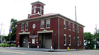
Fire Station No. 5 in Mechanicsville
|
|
| Location | Includes portions of University, Middle, Boyd, Arthur, McGhee, Clark, Oak, Deaderick, Tulip, Hannah, Western, and College Knoxville, Tennessee |
|---|---|
| Area | approximately 31 acres (13 ha) |
| Built | 1880–1920 |
| Architect | multiple |
| Architectural style | Queen Anne, Italianate, Victorian commercial, Gothic Revival, Shotgun |
| NRHP reference No. | 80003842 |
| Added to NRHP | July 18, 1980 |
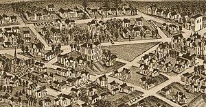
Mechanicsville is a historic neighborhood in Knoxville, Tennessee, United States. It is located just northwest of the city's downtown area. This neighborhood is one of Knoxville's oldest. It was created in the late 1860s for skilled workers. These workers were called "mechanics" back then, and they worked in the many factories nearby.
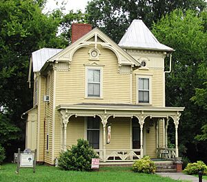
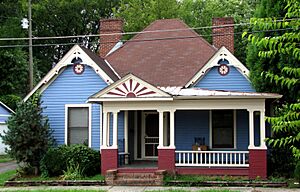
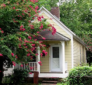
Mechanicsville still has many Victorian-style homes from the late 1800s. You can also find many "shotgun houses" from the early 1900s. In 1980, many buildings in Mechanicsville were added to the National Register of Historic Places. This made it the Mechanicsville Historic District. In 1991, it also became a local historic district. This means there are special rules to protect its historic look.
After the Civil War, new railroads brought many factories to the Second Creek valley. One of the first was the Knoxville Iron Company. It built a huge factory near Mechanicsville in 1868. The neighborhood was built to house workers, including Welsh iron specialists and African-American laborers. By the 1880s, Mechanicsville was surrounded by large factories and mills. It also had most of Knoxville's railroad repair shops.
In the early 1900s, Mechanicsville became a neighborhood mainly for African-American families. It was home to Knoxville College and Knoxville Medical College, which were historically black colleges. Many early black business owners and professors also lived here.
Contents
Where is Mechanicsville?
Mechanicsville is generally bordered by Interstate 40 to the south and Interstate 275 to the east. Beaumont Avenue is to the north, and Western Avenue (part of State Highway 62) is to the west. Knoxville's downtown area, including the Old City, is across I-40 to the southeast.
University Avenue splits Mechanicsville into two parts. "Old Mechanicsville" is the older, southeastern part. "New Mechanicsville" is the newer northern section. The large campus of Knoxville College is in the western part of Mechanicsville. Second Creek, which attracted many factories, flows just west of the neighborhood. Railroad tracks also run just south and east of Mechanicsville.
The Story of Mechanicsville
Civil War Times
During the Siege of Knoxville, Confederate soldiers surrounded the city. They hoped to make the Union forces inside give up. Confederate lines crossed through the Mechanicsville area. Their lookout points stretched between Arthur Street and Clark Street. Several Confederate cannons were also placed in the hills where Knoxville College is now. These cannons fired during the Battle of Fort Sanders.
Growing After the War
After the Civil War, Knoxville saw a big economic boom. This was thanks to new railroads and money from the North. Many factories were built along Second Creek. In 1867, over 100 Welsh immigrant families came from Pennsylvania. They were brought by the Richards brothers, Joseph and David, to work in a local factory. The Richards brothers bought land in Mechanicsville from railroad owner Charles McClung McGhee. This land was divided into lots, and the Welsh families began building homes. This new area, called "McGhee's Addition," was the first successful Welsh settlement in Tennessee.
In 1868, Civil War general Hiram S. Chamberlain and the Richards brothers started the Knoxville Iron Company. They built a huge factory across Second Creek from McGhee's Addition. Part of this factory, now called "The Foundry," is still standing today. Some houses in Mechanicsville still have fences made from iron from this factory.
As more factory workers moved in, Mechanicsville grew. The Welsh community expanded to include the Deaderick–Swann Addition. This area included much of modern Deaderick and Arthur streets. Residents here built many of Mechanicsville's fancy Victorian homes in the 1880s and 1890s. African-American factory workers settled mainly in the Middleton–Weatherford Addition. This was around Calloway and Boyd streets.
Mechanicsville residents voted to join Knoxville in 1882. Knoxville agreed, and Mechanicsville became its Ninth Ward on January 1, 1883. At that time, Mechanicsville had over 2,000 people. It also had three churches, two schools, and six general stores. Besides Knoxville Iron, other factories in the area included the Knoxville Brewing Company and the Standard Handle Company.
The 1900s and Today
As Welsh families became more successful, many moved to other parts of the city. Today, over 250 families in the Knoxville area can trace their family history back to these first immigrants. They still celebrate Saint David's Day to remember their Welsh heritage.
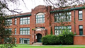
In the early 1900s, Mechanicsville became a thriving neighborhood for African American businesses and families. One of the first African-American schools was Fairview School, built in 1875. It was later renamed Moses School, and the current building was finished in 1930. Knoxville College, started in 1875, was the main black institution in the city for many years. Cansler Street in Mechanicsville is named after Charles W. Cansler, an important black leader in the early 1900s.
In the second half of the 1900s, Mechanicsville saw some changes. Many middle-class families moved to suburbs. Some old homes were torn down to build the highway that became I-40. Others became low-rent apartments. College Homes, a public housing project, was built near Knoxville College. Over time, many homes became empty.
Mechanicsville Now
Big efforts to improve Mechanicsville began in the 1970s. A group called Mechanicsville Citizens for a Better Community was formed. In 1985, Knoxville created the Mechanicsville Task Force. This group suggested ways to fix up old homes and build new ones.
In 1997, Knoxville's Community Development Corporation (KCDC) received a large grant. They used it to improve the College Homes area. The old apartment buildings were taken down. New single-family and duplex homes were built. These new homes were designed to look like the older houses in the neighborhood. KCDC also bought over 100 empty lots for new construction. These new homes were also designed to fit in with the historic style. Efforts were made to help low-income families rent or buy these homes.
Today, several companies have offices and businesses in the area. These include the Knoxville News-Sentinel, Cherokee Health Systems, Pilot Oil, Fort Sanders Health System, and a Food City grocery store.
A Special Historic Place
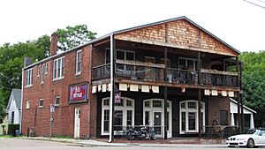
Mechanicsville's historic district is one of the oldest neighborhoods from Knoxville's growth after the Civil War. Some of its Victorian houses show unique Italianate and Gothic styles. These styles are not as common in nearby neighborhoods. The part of Old Mechanicsville along Calloway and Boyd has the most "shotgun houses" from the early 1900s in Knoxville.
Cool Buildings to See
- Fire Station No. 5 (419 Arthur Street): This two-story fire station was built in 1909. It is Knoxville's oldest fire station. It was added to the National Register in 1979.
- Moses School (221 Arthur Street): This three-story brick school building was built in 1930. A school has been on this spot since 1875. It is now home to Emerald Academy, Knoxville's only charter school.
- 501 Arthur (501 Arthur Street): This two-story brick building was built around 1910. It used to be a grocery store called Bradley Food Market. More recently, it was a Buddhist temple.
- 1524 Western Avenue: A two-story building with a unique wedge shape, built around 1900. It was originally a restaurant.
- 1545 Western Avenue: A two-story brick Victorian-style building from around 1900. It used to be Western Heights Hardware.
- 244 Deaderick Avenue: A two-story brick building from around 1900. It has a wedge shape to fit the street corner.
- 224 Deaderick Avenue: A two-story house with Gothic Revival style elements, built around 1900.
- 243 Deaderick Avenue: A two-story Queen Anne-style house with a fancy porch, built around 1890.
- 415 Clark Street: A one-story Queen Anne-style cottage built in 1910.
- 1007 Oak Avenue: A two-story Queen Anne-style house with a decorated iron fence, built around 1890.
- 1008 McGhee Avenue: A one-story shotgun house built in 1910.
- 1012 McGhee Avenue: A one-story shotgun house built around 1900.
- 1509 Boyd Street: A one-story shotgun house built around 1910.
 | James B. Knighten |
 | Azellia White |
 | Willa Brown |


