Calderwood Dam facts for kids
|
Calderwood Dam
|
|

Calderwood Dam
|
|
| Location | Blount / Monroe counties, Tennessee |
|---|---|
| Nearest city | Maryville, Tennessee |
| Area | 30 acres (12 ha) |
| Built | 1930 |
| Architect | I.V. Karpov |
| MPS | Blount County MPS; Pre-TVA Hydroelectric Power Development in Tennessee MPS |
| NRHP reference No. | 89001069 (original) 90001016 (increase) |
Quick facts for kids Significant dates |
|
| Added to NRHP | August 21, 1989 |
| Boundary increase | July 3, 1990 |
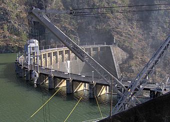
The Calderwood Dam is a large dam that makes electricity from water power. It is located on the Little Tennessee River in Blount and Monroe counties, in Tennessee. The dam was finished in 1930.
It is owned and cared for by Tapoco. Tapoco is part of the Aluminum Company of America (Alcoa). Even though Tapoco owns it, the Tennessee Valley Authority (TVA) controls how much water is in the dam's lake. This is done from Fontana Dam further upstream. The dam is named after Isaac Glidden Calderwood (1871–1941). He was an engineer for Alcoa and helped a lot with their early projects on the Little Tennessee River.
Calderwood Dam was one of four dams built by Alcoa in the Little Tennessee Valley. These dams included Cheoah, Santeetlah, and Chilhowee. They were all built to create electricity for Alcoa's aluminum factories in Blount County. Calderwood Dam was one of the last dams built in the Tennessee River area before the TVA took control in 1933. Alcoa even built a small town called Calderwood, Tennessee near the dam. This town was for the workers who built and maintained the dams. In 1989, Calderwood Dam was added to the National Register of Historic Places. This means it is an important historical site.
Contents
Where is Calderwood Dam Located?
Calderwood Dam is about 44 miles (71 km) upstream from where the Little Tennessee River joins the Tennessee River. The river flows west from North Carolina. The area around the dam is surrounded by mountains. The Great Smoky Mountains are to the north, and the Unicoi Mountains are to the south. U.S. Route 129 runs along the Blount County side of the river. This is the main road to get to the Calderwood area.
Exploring the Calderwood Area
The Calderwood area is built around a horseshoe-shaped bend in the river. This bend is called "The Narrows." The dam is at the upstream end of this bend. The powerhouse, service building, and the old Calderwood community are at the downstream end. The old community is now a recreation area.
You can reach the service building and recreation area by Housley Road. This road connects to US-129. Growdon Road continues past the service building to the powerhouse. However, this part of the road is only for walking. The Calderwood Overlook is a great spot to see the Calderwood Reservoir. It is located on US-129. A gravel road, also for walking, connects the overlook to Calderwood Dam.
How is Calderwood Dam Built?
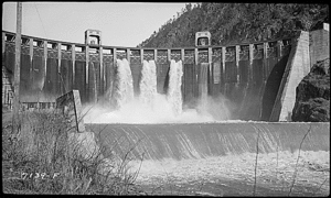
Calderwood Dam is made of concrete. It is 232 feet (71 m) high and 916 feet (279 m) wide. It has a spillway with 24 gates that curve at the top. A smaller "cushion" dam is located 370 feet (110 m) downstream. This cushion dam creates a pool of water. This pool helps protect the riverbed from the force of the water.
The Powerhouse and How it Works
Calderwood's powerhouse is about 1.2 miles (1.9 km) downstream from the dam. It is on the other side of the horseshoe bend in the river. Water enters a special opening just upstream from the dam. It then flows through a 2,150-foot (660 m) concrete tunnel. This tunnel carries the water to the other side of the land. From there, the water rushes down three large pipes called penstocks.
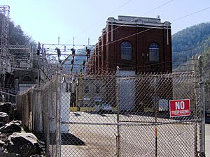
These penstocks are about 18 feet (5.5 m) wide. They range in length from 330 feet (100 m) to 388 feet (118 m). The water goes into a valvehouse, which is made of strong concrete. Inside, there are three Francis turbines. These turbines spin when the water hits them. The powerhouse is a larger brick building next to the valvehouse. It has three Westinghouse generators. Together, these generators can produce 140.4 megawatts of electricity. The powerhouse area is protected by a strong concrete wall. This wall helps against falling rocks from the nearby cliffs.
Calderwood Reservoir Details
The lake created by Calderwood Dam is called Calderwood Reservoir. It covers about 570 acres (230 ha). The water flows into it from an area of 1,856 square miles (4,810 km²). The reservoir's elevation is 1087.8 feet (331.6 m). It stretches for about 8 miles (13 km) along the river. About half of the reservoir is in Tennessee, and the other half extends into North Carolina.
A Brief History of Calderwood Dam
Alcoa started developing the Little Tennessee Valley in 1909. They needed huge amounts of electricity for their aluminum factories in Blount County. Superintendent I.G. Calderwood was in charge of building a railway line. This line went from Chilhowee to what is now Calderwood. You can still see the old railroad bridge supports in the river downstream from the dam. Engineers thought the railway would take six months to build. But Calderwood and his team finished it in just six weeks!
The first dam Alcoa built in the Little Tennessee Valley was Cheoah, finished in 1919. The second was Santeetlah, finished in 1928. Work on Calderwood Dam began in 1918. At first, tests suggested the site might not be good. But later tests showed it was stable. So, construction began in 1927. The first two parts that make electricity started working on June 22, 1930. A third part was added in 1938.
The special "cushion pool" design of Calderwood Dam was inspired by natural waterfalls. The curved top of the dam might have been influenced by the design of Ocoee Dam No. 1. That dam was finished in 1911 on the Ocoee River nearby. Calderwood's use of a tunnel to carry water to a powerhouse further downstream is similar to the Great Falls Dam complex. That dam was finished in 1916 on the Caney Fork in Middle Tennessee.
The Community of Calderwood
The town of Calderwood, Tennessee, was built in 1912. It was located downstream from the dam and powerhouse. Its purpose was to house the construction workers for Alcoa's projects. The community was first called "Alcoa." But its name changed to "Calderwood" in 1920. This happened when the company used the name "Alcoa" for its main company town near Maryville.
The Calderwood community grew to have almost two dozen houses. It also had two churches, a school, and a theater. But as the construction and maintenance work slowed down, most people left the town in the 1950s. All the houses were torn down. However, the school and theater (now used for storage) were added to Calderwood Dam's National Register listing in 2004.
 | Kyle Baker |
 | Joseph Yoakum |
 | Laura Wheeler Waring |
 | Henry Ossawa Tanner |


