
Fontana Dam facts for kids
Quick facts for kids Fontana Dam |
|
|---|---|
.jpg)
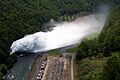
Fontana Dam and powerhouse (aerial view)
|
|
| Official name | Fontana Dam |
| Location | Graham / Swain counties, North Carolina, United States |
| Coordinates | 35°27′8″N 83°48′17″W / 35.45222°N 83.80472°W |
| Construction began | January 1, 1942 |
| Opening date | November 7, 1944 |
| Operator(s) | Tennessee Valley Authority |
| Dam and spillways | |
| Impounds | Little Tennessee River |
| Height | 480 feet (150 m) |
| Length | 2,365 feet (721 m) |
| Reservoir | |
| Creates | Fontana Lake |
| Total capacity | 1,443,000 acre-feet (1.780 km3) |
| Power station | |
| Installed capacity | 238.5 MW |
The Fontana Dam is a huge wall built across the Little Tennessee River in North Carolina, United States. It's a hydroelectric dam, which means it uses the power of moving water to create electricity. The dam was built by the Tennessee Valley Authority (TVA) in the early 1940s. It helped provide a lot of electricity during World War II, especially for making aluminum. It also brought power to areas that didn't have it before.
Fontana Dam is 480 feet (150 m) tall, making it the tallest dam in the eastern part of the United States. When it was first built, it was the fourth-tallest dam in the entire world! The dam and its related structures were added to the National Register of Historic Places in 2017.
The dam creates a large body of water called Fontana Lake, which covers about 10,230 acres (4,140 ha). This lake stretches along the edge of the Great Smoky Mountains National Park. A famous hiking path, the Appalachian Trail, even crosses right over the top of the dam. The dam is named after a town called Fontana that used to be there. This town, which was a center for lumber and copper mining, is now covered by the lake. The name "Fontana" comes from an Italian word meaning "fountain."
Contents
Where is Fontana Dam?
The Little Tennessee River starts in the mountains of Georgia. It flows for about 135 miles (217 km) before joining the Tennessee River. Fontana Dam is located about 61 miles (98 km) upstream from where the Little Tennessee River meets the Tennessee River. It's in a quiet area where the river briefly turns south.
The dam is about a 30-mile (48 km) drive from the closest cities. These cities are Maryville, Tennessee to the west, Bryson City, North Carolina to the east, and Robbinsville, North Carolina to the south. A small vacation spot called Fontana Village is located just south of the dam. This village was first built as a temporary home for the workers who constructed the dam.
To the north of the dam are the Great Smoky Mountains. To the south, you'll find the Yellow Creek Mountains, which are mostly part of the Nantahala National Forest. Fontana is the highest of five dams on the Little Tennessee River. Other dams downstream include Cheoah Dam, Calderwood Dam, Chilhowee Dam, and Tellico Dam.
.jpg)
Fontana Lake covers a 29-mile (47 km) part of the Little Tennessee River. It also extends into the lower 11 miles (18 km) of the Tuckasegee River and about 5 miles (8.0 km) of the Nantahala River. Many fast-flowing mountain streams, some dropping thousands of feet from the Great Smokies, flow into the north side of Fontana Lake. Eagle Creek and Hazel Creek are two of the most well-known streams. They form large bays just upstream from the dam.
North Carolina Highway 28 is the main road that leads to the Fontana Dam area. It crosses a bridge downstream from the dam. About 11 miles (18 km) west of the dam, this road meets U.S. Route 129 at Deals Gap. East of the dam, NC-28 follows the lake's south shore for about 25 miles (40 km) before meeting U.S. Route 74.
There used to be a special railway called a funicular at the Fontana Dam site. It was a narrow gauge railway that took tourists up and down the steep slopes. However, it is now closed.
Dam Size and Power
Fontana Dam is 2,365 feet (721 m) long and 480 feet (150 m) high. This makes it the tallest dam in the eastern United States. The dam can hold a lot of water to prevent floods, specifically 513,965 acre-feet (633,966,000 m3). Its three generators can produce a total of 293.6 megawatts of electricity.
Fontana Lake has 238 miles (383 km) of shoreline and 10,230 acres (4,140 ha) of water surface. The water level in the lake changes by about 57 feet (17 m) each year.
Building the Dam

The Aluminum Company of America (Alcoa) started looking at the Little Tennessee Valley around 1910. They wanted to find a good place to build a dam for electricity. Alcoa needed a lot of power for its aluminum factories in nearby Alcoa, Tennessee. By 1930, Alcoa had already built Cheoah and Calderwood dams. They also built Santeetlah Dam on the Cheoah River. By the mid-1930s, Alcoa had checked out the Fontana site. They bought about 15,000 acres (6,100 ha) of land for the dam.
In 1935, the Tennessee Valley Authority (TVA) became interested in the Fontana project. TVA was worried about how the Little Tennessee River affected floods in the larger Tennessee Valley. TVA and Alcoa talked about TVA taking over the Fontana project. However, TVA couldn't get money from the government until World War II started in 1941. During the war, there was a huge need for more aluminum production.
On August 14, 1941, TVA and Alcoa signed an agreement. This agreement gave TVA control of Fontana Dam. It also gave TVA control over how much water was released from Alcoa's other dams in the Little Tennessee Valley. In return, Alcoa was guaranteed to get most of the electricity from these dams for at least 20 years. The U.S. Congress approved the funding on December 17, 1941. Construction of Fontana Dam began very quickly, on January 1, 1942.

Building Fontana Dam and its lake meant buying 68,292 acres (27,637 ha) of land. About 5,125 acres (2,074 ha) of this land was covered in trees and had to be cleared. Around 1,311 families, 1,047 graves, and more than 60 miles (97 km) of roads had to be moved out of the area. The towns of Fontana, Bushnell, Forney, and Judson were completely covered by Fontana Lake.
A temporary village called Welch Cove was built just south of the dam. It was later renamed Fontana Village. This village housed the workers who built the dam. By 1943, there were 5,000 workers, even though there were not many workers available across the country. Today, Fontana Village is a summer resort. Some of the original buildings from the 1940s are still used.
The way the dam was designed was special for TVA at that time. The dam needed a lot of concrete, about 2,818,000 cubic yards (2,155,000 m³). Engineers worried that the heat released as the concrete dried would get trapped for years. This could cause cracks to form in the dam. To help release this heat, engineers divided the dam into sections. They put in pipes to help cool the concrete.
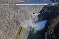
The dam's spillway, which lets out excess water, was another challenge. Engineers were concerned that water dropping 400-foot (120 m) would cause damage at the dam's base. So, a special spillway was designed. It drains water through two large pipes, each 34 feet (10 m) wide. These pipes lead into a tunnel with a system to control the water flow. The main person behind the dam's design was TVA's chief architect, Roland Wank.
Fontana Dam cost about $70,420,688.48 to build. The dam's gates were closed on November 11, 1944. Two power-generating units started working on January 20, 1945. This provided important energy for making aluminum in the final months of World War II. Later, over 40,000 acres (16,000 ha) along the north shore of Fontana Lake were given to the Great Smoky Mountains National Park. Several thousand acres along the south shore were given to the U.S. Forest Service.
Cracks in the Dam
Even with its clever design, cracks were seen on the dam's surface in 1949. More cracks appeared in 1972 and grew larger in 1973. After many studies, experts found that the cracks were caused by stress in the curved parts of the dam. This stress came from the concrete expanding due to heat. The cracking got worse because of a chemical reaction in the concrete. This reaction made the concrete expand even more.
To fix this, steel cables were used to strengthen the area around the cracks. Also, a special cut was made in 1976 to relieve the stress in the cracked area. New cuts are made every 4 to 5 years to stop the cracks from growing. The most recent cuts were done in 2016.
Images for kids
-
Fontana Dam and powerhouse (aerial view)
-
Fontana's spillway in operation
-
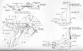
Design plan for Fontana Dam, circa 1941
-
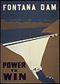
"Fontana Dam. Power to win." World War II poster
