Nantahala River facts for kids
Quick facts for kids Nantahala River |
|
|---|---|
|
Location of Nantahala River mouth
|
|
| Other name(s) | Tributary to Little Tennessee River |
| Country | United States |
| State | North Carolina |
| County | Clay Macon Swain |
| Physical characteristics | |
| Main source | confluence of Kilby Creek, Gulf Fork, and Big Laurel Branch just west of Scream Ridge 3,800 ft (1,200 m) 35°01′04″N 083°30′24″W / 35.01778°N 83.50667°W |
| River mouth | Little Tennessee River Fontana Lake 1,708 ft (521 m) 35°23′00″N 083°30′24″W / 35.38333°N 83.50667°W |
| Length | 47.85 mi (77.01 km) |
| Basin features | |
| Progression | generally north |
| River system | Little Tennessee River |
| Basin size | 175.33 square miles (454.1 km2) |
| Tributaries |
|
| Waterbodies | Nantahala Lake, Fontana Lake |
| Bridges | Standing Indian Loop, US 64, Thunderstruck Lane, Swinging Bridge Lane, Nantahala Dam Road, Junaluska Road, Wayah Road (x8), US 74, Pardon Bridge Road, Old Storehouse Road, NC 28 |
The Nantahala River is a beautiful river located in western North Carolina, United States. It flows through the Nantahala National Forest and is close to the famous Great Smoky Mountains National Park. A highway, U.S. Route 19/74, runs alongside the river, offering many spots for picnics.
Long ago, in 1839, this area was part of the Trail of Tears. This was a sad time when the Cherokee people were forced to leave their homes and move far away to the west.
The river begins near the border of Georgia and North Carolina. It then flows into the Little Tennessee River at Fontana Lake. This lake is a large reservoir created by the Fontana Dam.
The name Nantahala comes from the Cherokee people. It means "Land of the Noonday Sun." This is because the river flows through a deep, narrow gorge. In some parts of the gorge, the sun can only reach the ground when it is directly overhead at midday. Long ago, Cherokee towns along the Nantahala and nearby rivers were known as the Valley Towns.
Contents
Fun on the Nantahala River
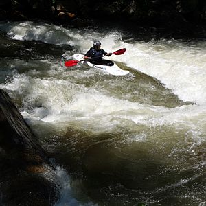
The Nantahala River is a very popular spot for outdoor adventures. Many people come here to enjoy whitewater rafting, canoeing, and kayaking.
Whitewater Rafting and Kayaking
Commercial rafting trips started on the Nantahala in 1972. This was when the Nantahala Outdoor Center first opened. Since then, thousands of people visit the river every year for paddling. Today, there are ten different companies that offer guided rafting trips. They all have special permits from the Forest Service to operate.
The Nantahala is one of the most popular rivers in the southeastern United States for paddlers. It's great for people of all skill levels, from beginners to experienced adventurers.
Fishing for Trout
The Nantahala River is also a top spot for fly fishing. An organization called Trout Unlimited has even called it one of the "100 Best Trout Streams in America." It's known as one of the best places to catch trout in the Eastern United States.
The river is often used for fishing competitions and training. Both the US Men's and US Youth National Fly Fishing teams practice here. For example, in 2015, the US Youth National Fly Fishing Championship was held on the Nantahala.
Exploring the River Sections
The Nantahala River has different sections, each offering unique experiences.
The Lower Run: Rapids and Recreation
The most popular part for rafting is called the Lower Run. It's about 8 miles (13 km) long and has exciting Class II and III rapids. This section stretches from the Nantahala Powerhouse to the town of Wesser.
- Access Points: There are two main places to start your trip. One is just below the Nantahala Powerhouse. The other is at the Ferebee Memorial Picnic Area, near where US 74 crosses the river.
- Exciting Rapids: Some of the well-known rapids include "Patton's Run," "Quarry," "Whirlpool," "Surfers," "Bulls Run," and "Upper Nantahala Falls."
- The End of the Run: Just past the main take-out point in Wesser is Lower Nantahala Falls, also known as Wesser Falls. This is a steep drop with many rocks. Right after this, the Nantahala River flows into Fontana Lake.
The amount of water flowing in this section depends on releases from Nantahala Lake. These releases are controlled by Duke Energy. The Nantahala Dam is a special kind of dam called a diversion dam. This means that most of the river's water is sent through a long, 5.5-mile (8.9 km) underground pipe called a penstock. This water then flows through the Nantahala Powerhouse to generate electricity before returning to the river far downstream. The river is "on" for rafting when Duke Energy is making electricity. From late spring to early fall, Duke Energy follows a regular schedule to release water, which helps support the commercial rafting trips.
Because the water comes from deep underground, it is always very cold, usually around 50-59 degrees Fahrenheit (10-15 degrees Celsius).
Lower Run: A Trout Fishing Paradise
This part of the river is also a favorite for fly fishing. Even though it's regularly stocked with fish, it has a healthy population of wild Rainbow Trout that were born in the stream. The river also has a strong population of Brown Trout, and many of them grow very large. The record for the largest Brown Trout caught in North Carolina was 24 lb 10 oz (11.2 kg). It was caught in the Lower Nantahala in 1998! It's not uncommon to find Brown Trout weighing 10 lb (4.5 kg) or more here.
The Upper Run: Challenges and Cold Water Fishing
The upper section of the river goes from the Nantahala Dam to the Nantahala Powerhouse. The very top part, just below Whiteoak Falls, is known as the Nantahala Cascades. This is a very steep and difficult whitewater route.
- Upper Nantahala Challenges: After the cascades, the river becomes the Upper Nantahala. It flattens out a bit but is still a challenging Class III-IV run.
- Water Flow: Normally, most of the river's water is diverted through the penstock. So, the only water flowing through this section comes from smaller streams like Dick's Creek. However, during very rainy periods or if the powerhouse is shut down for a long time, the river flows full. This section is narrow and has several Class III+ to V rapids. Some of these are called "The Horns of God," "Big Kahuna," and "Chinese Feet."
Upper Run: Winter Trout Fishing
In the winter months, the Upper Nantahala is a special place for trout fishing. The state of North Carolina adds about 10,000 Brown, Rainbow, and Brook Trout to the river each year. This is in addition to the trout that already live there naturally.
 | DeHart Hubbard |
 | Wilma Rudolph |
 | Jesse Owens |
 | Jackie Joyner-Kersee |
 | Major Taylor |


