Cheoah River facts for kids
Quick facts for kids Cheoah River |
|
|---|---|

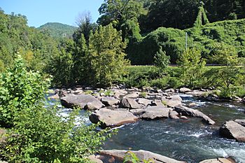
Cheoah River in Tapoco, North Carolina
|
|
| Other name(s) | Tributary to Little Tennessee River |
| Country | United States |
| State | North Carolina |
| County | Graham Swain |
| Physical characteristics | |
| Main source | Confluence of Sweetwater and Tulula Creeks Robbinsville, North Carolina 1,993 ft (607 m) 35°19′38.3196″N 83°48′7.635″W / 35.327311000°N 83.80212083°W |
| River mouth | Little Tennessee River 1,106 ft (337 m) 35°26′55.307″N 83°56′22.65″W / 35.44869639°N 83.9396250°W |
| Length | 18.16 mi (29.23 km) |
| Basin features | |
| Progression | northwest |
| River system | Little Tennessee → Tennessee → Ohio → Mississippi |
| Basin size | 215.14 square miles (557.2 km2) |
| Tributaries |
|
| Waterbodies | Santeetlah Lake |
The Cheoah River is a beautiful river in North Carolina, United States. It's a smaller river, also called a tributary, that flows into the bigger Little Tennessee River.
This river is found in Graham County, which is in the far western part of North Carolina. It's quite close to the town of Robbinsville. The Cheoah River is about 20 miles (32 kilometers) long.
Its journey starts high up in the Appalachian Mountains. From there, it flows northwest, passing near Robbinsville. It then reaches Lake Santeetlah before continuing its path towards the Tennessee border. The river finally joins the Little Tennessee River between the Cheoah Dam and Lake Calderwood.
Where Does the Cheoah River Flow?
The Cheoah River begins where two smaller streams meet. These streams are called Sweetwater Creek and Tulula Creek. This meeting point is near Robbinsville, North Carolina. The river starts at an elevation of about 1,993 feet (607 meters) above sea level.
As it flows, the Cheoah River travels through scenic areas. It eventually empties into the Little Tennessee River. This happens at an elevation of about 1,106 feet (337 meters). The river's path generally moves towards the northwest.
Part of a Bigger River System
The Cheoah River is an important part of a much larger river system. Think of it like branches on a tree.
- The Cheoah River flows into the Little Tennessee River.
- The Little Tennessee River then joins the Tennessee River.
- The Tennessee River flows into the Ohio River.
- Finally, the Ohio River empties into the mighty Mississippi River.
This means water from the Cheoah River eventually makes its way all the way to the Gulf of Mexico! The area of land that drains into the Cheoah River is about 215 square miles (557 square kilometers).
Other Names for the River
Sometimes, rivers have different names they've been called over time. According to the Geographic Names Information System, the Cheoah River has also been known by these names:
- Cheowa River
- Cheowah River
 | Anna J. Cooper |
 | Mary McLeod Bethune |
 | Lillie Mae Bradford |


