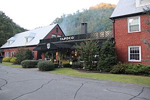
Tapoco, North Carolina facts for kids
Quick facts for kids
Tapoco, North Carolina
|
|
|---|---|

Tapoco Lodge
|
|
| Country | United States |
| State | North Carolina |
| County | Graham |
| Elevation | 1,171 ft (357 m) |
| Time zone | UTC-5 (Eastern (EST)) |
| • Summer (DST) | UTC-4 (EDT) |
| Area code(s) | 828 |
| GNIS feature ID | 995845 |
Tapoco is a small place in Graham County, North Carolina, in the United States. It's known as an unincorporated community. This means it's a group of homes and businesses that isn't officially a town or city with its own local government.
Contents
What is Tapoco Like?
Tapoco is located along U.S. Route 129. This road is a major route in the area. The community is also very close to the Little Tennessee River. This river is an important natural feature.
Where is Tapoco Located?
Tapoco is found in the western part of North Carolina. It is about 11 miles (18 kilometers) northwest of a town called Robbinsville. The area is known for its beautiful mountain scenery.
How Tapoco Got Its Name
The name "Tapoco" comes from a company that used to operate there. It's an acronym, which means it's made from the first letters of a longer name. Tapoco stands for the Tallassee Power Company. This company was involved in generating electricity.
Tapoco's Past and Present
For many years, Tapoco had its own post office. This was a central place for people to send and receive mail. However, the post office closed its doors on October 26, 1995. Today, one of the most well-known spots in Tapoco is the Tapoco Lodge. It's a historic place that attracts visitors.
 | Shirley Ann Jackson |
 | Garett Morgan |
 | J. Ernest Wilkins Jr. |
 | Elijah McCoy |


