Nantahala, North Carolina facts for kids


Nantahala Township (/ˌnæntəˈheɪlə/) is a community in Macon County, United States. It is located in the western part of North Carolina. About 1,700 people live there.
The name Nantahala comes from the Cherokee language. It can mean "The sun between them." Another meaning is "land of the noonday sun." This refers to how deep the gorge is. The Nantahala valley was a key meeting point for the Cherokee people. It connected different Cherokee towns. The town of Aquone is nearby. Its name means "by the river" in Cherokee.
Long ago, Cherokee settlements were likely all over the Nantahala river valley. This includes land now covered by Nantahala Lake. Famous explorers may have visited the Nantahala valley. These include the Spanish explorer Hernando de Soto in 1540. The English botanist William Bartram also visited in the 1700s. Today, Nantahala gets most of its money from tourism. People love to visit for its natural beauty and outdoor activities.
Contents
Nantahala National Forest: A Natural Treasure
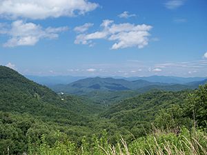
The Nantahala National Forest was created in 1920. It is the largest of North Carolina's four national forests. This huge forest covers over 531,000 acres. That's more than 800 square miles! It has many different types of trees, about 100 species. The land here ranges from high mountains to lower valleys. Elevations go from 5,800 feet down to 1,200 feet.
The forest is divided into three main areas. These are Cheoah, Tusquitee, and Nantahala. A famous hiking trail, the Appalachian Trail, also runs through this forest. Many people enjoy hiking its paths.
Nantahala River: Adventure on the Water
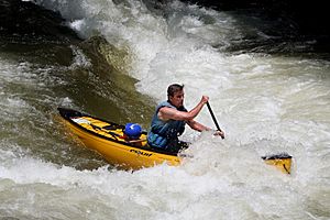
The Nantahala River is a popular spot for outdoor fun. It flows through the Nantahala National Forest. U.S. Route 19 follows the river's path. People come here for exciting activities. These include whitewater rafting, kayaking, and fishing.
The Nantahala River has different levels of rapids. These are rated from Class I to Class III.
- Class I rapids are easy and smooth. They have gentle curves and occasional sand banks.
- Class II rapids are moderate. They have faster water and regular waves. There are clear paths between rocks. You need to know how to steer a raft. Guides are a good idea for beginners.
- Class III rapids are moderately difficult. They have many high and uneven waves. There are rocks and swirling water. The paths are clear but narrow. You need experience to raft these parts. It's good to look at them first if you don't know them well.
The Class III rapids are at the end of the river. They last for about 30 seconds. A typical whitewater rafting trip is eight miles long. It usually takes 3 to 4 hours. Professional guides lead these tours. They are trained in first aid. The river's water flow is controlled by a dam. This means there's good water for rafting all year.
Kayaking is also popular here. Some people use "duckys." These are inflatable kayaks. They make it easier to go down the river. Duckys are suggested for experienced rafters. They offer a more exciting trip.
Fishing: Catching Trout
The Nantahala River is a great place for fishing. It has many stream-bred trout. If you want to fish here, you need to be careful when wading in the water.
Nantahala Lake: A Man-Made Wonder
Nantahala Lake is located in the Nantahala National Forest. It sits high up, about 3,000 feet above sea level. The lake was created in 1942 by Nantahala Power. It helped make electricity for the war effort. The historic Cherokee village of Aquone was once where the lake is now.
Duke Power Company manages Nantahala Lake. Some parts of the shoreline are open to the public. These areas are managed by the Nantahala National Forest. The NCWRC (North Carolina Wildlife Resources Commission) also helps. They maintain public boating areas. The lake is home to many fish. You can find walleye, lake trout, brown trout, bluegill, crappie, smallmouth bass, and largemouth bass.
Nantahala Gorge: A Deep Valley
The Nantahala Gorge is a deep valley. It separates Graham County from Macon and Swain County. The gorge includes nine miles of the Nantahala River. It ends at Fontana Lake. This gorge is special. It is the only place in North Carolina where you can fish for trout at night.
The Nantahala Gorge also offers exciting "canopy tours." The Nantahala Gorge Canopy Tours opened in 2009. It was the first zipline and canopy tour in the area. This attraction lets you "fly" through the trees. It's a three-hour experience over 20 acres. Gravity helps you glide down a gentle slope. A "canopy ranger" guides you. They point out natural features of the forest. They also share interesting facts about the gorge's history and culture.
Nantahala Outdoor Center: Adventure Hub
The Nantahala Outdoor Center (NOC) was started in 1972. It is in Bryson City, North Carolina. The NOC is famous for its guided trips. They offer kayaking, canoeing, and rafting adventures.
A man named John Burton was one of the first people to work at the NOC. He later became its president. He also competed in the 1972 Summer Olympic Games in Munich. Whitewater slalom kayaking became an Olympic sport that year. Now, the NOC is a training facility for U.S. Olympic athletes. They train here for kayak and canoe events.
Besides water sports, the NOC offers many other guided activities. These include fly-fishing, hiking, nature photography, train rides, and mountain biking. The center also has a clothing store, places to stay, and three restaurants. It's a true hub for outdoor adventure!
 | Janet Taylor Pickett |
 | Synthia Saint James |
 | Howardena Pindell |
 | Faith Ringgold |


