Tallulah River facts for kids
This article is about the river. For the town, see Tallulah Falls, Georgia, for the lake, see Tallulah Falls Lake and for the waterfalls and gorge, see Tallulah Gorge.

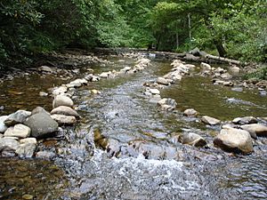
The Tallulah River is a long river, about 47.7 miles (76.8 km) (76.8 km) in length. It flows through the states of Georgia and North Carolina. The river starts in Clay County, North Carolina, close to Standing Indian Mountain. This area is part of the Southern Nantahala Wilderness.
From North Carolina, the Tallulah River flows south into Georgia. It crosses the state line into Towns County. The river then travels through Rabun County. Finally, it reaches its end in Habersham County.
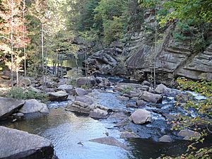
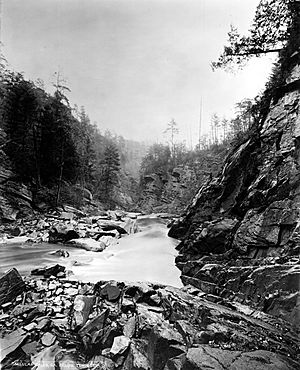
The Tallulah River is famous for cutting through a rock area to create the Tallulah Gorge. This gorge is home to several beautiful waterfalls, which are often called Tallulah Falls. The Tallulah River eventually meets the Chattooga River. Together, they form the Tugaloo River at Lake Tugalo in Habersham County. The Tugaloo River then joins South Carolina's Seneca River at Lake Hartwell. These two rivers combine to create the Savannah River, which flows all the way to the Atlantic Ocean.
Contents
Exploring the Tallulah River's Path
The Tallulah River stretches for about 48 miles (77 km) (77 km) from where it begins to where it meets the Tugaloo River. The area that drains water into the Tallulah River is called its basin. This basin covers about 184 square miles (480 km2) (477 km²). This measurement is taken near the Tallulah Falls Hydroelectric Plant in Habersham County, Georgia.
Lakes Along the River
The lower part of the Tallulah River has a series of lakes. These lakes were created by hydroelectric dams. These dams are operated by Georgia Power and use the river's flow to make electricity. The first lake in this series, starting from the north, is Lake Burton. After Lake Burton, you will find Lake Seed, followed by Lake Rabun. The last lake in the series is Lake Tallulah Falls.
From Tallulah Falls Lake, the river flows through the stunning Tallulah Gorge. It then becomes part of Lake Tugalo. The other part of Lake Tugalo is formed by the Chattooga River. The border between Habersham and Rabun counties follows the Tallulah River for about 0.5 miles (0.80 km) (0.8 km) downstream from the Tallulah Falls Lake dam.
The Upper Tallulah River Basin
The upper part of the Tallulah River Basin is the area upstream from Lake Burton. This includes parts of northwestern Rabun County, northeastern Towns County, and some of Clay County, North Carolina. The United States Geological Survey collects important data from this area. They have a station where the river crosses Plum Orchard Road.
This upper basin includes a section of the river that is about 14.3 miles (23 km) long. It drains an area of 56.5 square miles (146 km²). This region gets a lot of rain, at least 72 inches (183 cm) every year. The entire area is inside the Chattahoochee National Forest. About one-third of this land is part of the Southern Nantahala Wilderness. About one-fifth of the land is privately owned. The main smaller rivers that flow into the Tallulah River in Rabun County are Coleman River and Persimmon Creek.

The upper Tallulah River Basin is very beautiful and rugged. The highest points are in North Carolina, on Standing Indian Mountain. This mountain is 5,499 feet (1,676 meters) high, and it is where the Tallulah River begins. After entering Georgia and passing through the old mining and logging town of Tate City, Georgia, the river goes into what is called Tallulah’s upper gorge. This is also known as the Rock Mountain Gorge.
This upper "gorge" is not as dramatic as the more famous Tallulah Gorge. It starts just upstream from where the Coleman River joins the Tallulah River. It runs for almost 3 miles (5 km) (4.8 km) past Rock Mountain on the west side of the river. You can visit this scenic "gorge" by driving along the Tallulah River Road (Forest Service Road 70). This road follows an old railroad path. It ends in the Southern Nantahala Wilderness and is the only way to reach Tate City, North Carolina.
Today, the upper Tallulah River Basin is heavily wooded. However, in the 1930s, it was almost completely cleared by logging. This happened before the Chattahoochee National Forest was created to protect the land.
What Does "Tallulah" Mean?
For a long time, people in Georgia thought that "Tallulah" was a word from the Cherokee language. This was because the Cherokee people have a strong history in the state. In the late 1800s, people promoting tourism said that "tallulah" meant "thundering waters" in Cherokee.
Later, some experts thought that "tallulah" might mean "terrible" in Cherokee. Others suggested it came from different words. However, it is now believed that the word "Tallulah" actually has no meaning in the Cherokee language.
Instead, experts who study ancient cultures now think the word likely came from the Okonee language. In Okonee, the word talula means "town." The Okonee people lived in northeastern Georgia and northwestern South Carolina for hundreds of years. They were there before the Cherokee people arrived.
Based on archaeological studies, the Cherokee people seem to have settled parts of their homeland by the mid to late 1500s. For example, they had built a special meeting house by the late 16th century. This was at the Coweeta Creek site on the upper Little Tennessee River in present-day North Carolina. The Overhill Cherokee also used the term "Tallulah." They were known to have a town called Tallulah on the part of the Little Tennessee River that flowed on the west side of the Appalachian Mountains. The Muscogee Creek people also lived in this area before the Cherokee pushed them out.
 | William L. Dawson |
 | W. E. B. Du Bois |
 | Harry Belafonte |


