Copperhill, Tennessee facts for kids
Quick facts for kids
Copperhill, Tennessee
|
|
|---|---|

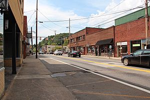
Downtown Copperhill
|
|

Location of Copperhill in Polk County, Tennessee.
|
|
| Country | United States |
| State | Tennessee |
| County | Polk |
| Founded | 1890 |
| Incorporated | 1913 |
| Area | |
| • Total | 1.80 sq mi (4.67 km2) |
| • Land | 1.77 sq mi (4.58 km2) |
| • Water | 0.03 sq mi (0.08 km2) |
| Elevation | 1,470 ft (448 m) |
| Population
(2020)
|
|
| • Total | 443 |
| • Density | 250.42/sq mi (96.67/km2) |
| Time zone | UTC-5 (Eastern (EST)) |
| • Summer (DST) | UTC-4 (EDT) |
| ZIP code |
37317
|
| Area code(s) | 423 |
| FIPS code | 47-17000 |
| GNIS feature ID | 1281278 |
Copperhill is a small city in Polk County, Tennessee, United States. In 2020, 443 people lived there. It is part of the larger Cleveland area. Copperhill is known for its past in copper mining and is now a popular spot for tourists.
Contents
History
A Mining Town's Past
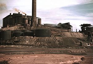
Copperhill is located in a special area called the Copper Basin. This place was once home to a very large copper mining operation. Mining started here in the 1840s and continued until 1987.
Around the time of the American Civil War, a method was used to remove sulfur from the copper ore. Workers would build huge bonfires and throw the ore into them. This burning process released sulfur into the air. To fuel these fires, most of the trees in the valley were cut down.
Environmental Impact and Recovery
The sulfur released from the fires caused acid rain. This acid rain stopped new plants from growing. Because there were no trees or plants to hold the soil, the red clay washed away from the hills. For many years, until the 1980s, the area looked bare and red, almost like the planet Mars!
Later, special factories were built to turn the sulfur into useful products. Today, the area looks much greener. A big effort costing millions of dollars helped replant trees and bring back the natural environment.
The copper mines and sulfur factories are now closed. Most of the old buildings and equipment have been removed. The company Glenn Springs Holdings has worked to clean up the local creeks and rivers. Now, the water quality is almost perfect, according to studies by the EPA and Tennessee Department of Environmental Conservation.
Copperhill Today: A Tourist Spot
Today, Copperhill is a fun place for visitors. You can take train rides from Blue Ridge, Georgia, on the Blue Ridge Scenic Railway. There are also train trips from the Gee Creek Wilderness on the Hiwassee River train route.
Many people come to Copperhill for exciting outdoor activities. Whitewater rafting on the Ocoee River is very popular. You can also enjoy mountain biking and hiking in the area. Copperhill was even a host for the whitewater events during the 1996 Summer Olympics.
Geography
Location and Twin City
Copperhill is in the very southeastern part of Tennessee. It sits right on the border with North Georgia. It has a "twin city" called McCaysville, Georgia. These two cities are like one town, built along a river.
The river is called the Toccoa River in Georgia and the Ocoee River in Tennessee. The state line cuts diagonally through streets and even buildings! You can often see a blue line marking the border on the streets.
The main street in Copperhill is Ocoee Street (Tennessee State Route 68). This street becomes Toccoa Street (Georgia State Route 60) when you cross into McCaysville. A bridge over the river connects them to Blue Ridge Drive (Georgia 5).
Flooding and Area Codes
In 1990, a big flood hit the towns. However, it's hard to see any damage today. The Tennessee Valley Authority raised the nearby Blue Ridge Dam. This helped prevent any more floods from the river.
Because of the state line, homes and businesses in Copperhill have the area code 423. Those in McCaysville have the area code 706.
According to the United States Census Bureau, Copperhill covers about 1.9 square miles (4.9 square kilometers). Most of this area is land, with a small part being water.
Population Information
| Historical population | |||
|---|---|---|---|
| Census | Pop. | %± | |
| 1920 | 1,102 | — | |
| 1930 | 1,050 | −4.7% | |
| 1940 | 1,005 | −4.3% | |
| 1950 | 924 | −8.1% | |
| 1960 | 638 | −31.0% | |
| 1970 | 563 | −11.8% | |
| 1980 | 418 | −25.8% | |
| 1990 | 362 | −13.4% | |
| 2000 | 511 | 41.2% | |
| 2010 | 354 | −30.7% | |
| 2020 | 443 | 25.1% | |
| Sources: | |||
2020 Census Details
In 2020, there were 443 people living in Copperhill. There were 184 households and 97 families. Most residents, about 86%, identified as White (non-Hispanic).
| Race | Number | Percentage |
|---|---|---|
| White (non-Hispanic) | 381 | 86.0% |
| Black or African American (non-Hispanic) | 2 | 0.45% |
| Native American | 1 | 0.23% |
| Asian | 1 | 0.23% |
| Other/Mixed | 19 | 4.29% |
| Hispanic or Latino | 39 | 8.8% |
Climate
The weather in Copperhill has hot, humid summers. Winters are usually mild to cool. According to the Köppen Climate Classification system, Copperhill has a humid subtropical climate. This type of climate is often shown as "Cfa" on climate maps.
| Climate data for Murphy 4ESE, North Carolina (1991–2020 normals, extremes 1873–present) | |||||||||||||
|---|---|---|---|---|---|---|---|---|---|---|---|---|---|
| Month | Jan | Feb | Mar | Apr | May | Jun | Jul | Aug | Sep | Oct | Nov | Dec | Year |
| Record high °F (°C) | 76 (24) |
81 (27) |
88 (31) |
92 (33) |
91 (33) |
98 (37) |
100 (38) |
99 (37) |
96 (36) |
93 (34) |
84 (29) |
77 (25) |
100 (38) |
| Mean maximum °F (°C) | 67.1 (19.5) |
71.3 (21.8) |
77.9 (25.5) |
84.7 (29.3) |
87.0 (30.6) |
90.7 (32.6) |
92.5 (33.6) |
92.1 (33.4) |
89.5 (31.9) |
83.0 (28.3) |
76.5 (24.7) |
68.0 (20.0) |
93.8 (34.3) |
| Mean daily maximum °F (°C) | 49.8 (9.9) |
53.5 (11.9) |
61.6 (16.4) |
70.8 (21.6) |
77.5 (25.3) |
83.5 (28.6) |
86.6 (30.3) |
86.0 (30.0) |
81.3 (27.4) |
71.8 (22.1) |
61.4 (16.3) |
52.7 (11.5) |
69.7 (20.9) |
| Daily mean °F (°C) | 37.5 (3.1) |
40.8 (4.9) |
47.7 (8.7) |
56.0 (13.3) |
64.1 (17.8) |
71.3 (21.8) |
74.9 (23.8) |
74.2 (23.4) |
68.6 (20.3) |
57.5 (14.2) |
47.1 (8.4) |
40.5 (4.7) |
56.7 (13.7) |
| Mean daily minimum °F (°C) | 25.3 (−3.7) |
28.0 (−2.2) |
33.8 (1.0) |
41.2 (5.1) |
50.7 (10.4) |
59.2 (15.1) |
63.2 (17.3) |
62.3 (16.8) |
55.8 (13.2) |
43.3 (6.3) |
32.8 (0.4) |
28.4 (−2.0) |
43.7 (6.5) |
| Mean minimum °F (°C) | 8.4 (−13.1) |
13.4 (−10.3) |
18.9 (−7.3) |
27.2 (−2.7) |
36.2 (2.3) |
48.8 (9.3) |
56.2 (13.4) |
54.9 (12.7) |
43.3 (6.3) |
29.1 (−1.6) |
19.8 (−6.8) |
14.7 (−9.6) |
5.7 (−14.6) |
| Record low °F (°C) | −16 (−27) |
−4 (−20) |
−3 (−19) |
18 (−8) |
25 (−4) |
35 (2) |
46 (8) |
48 (9) |
28 (−2) |
21 (−6) |
6 (−14) |
−4 (−20) |
−16 (−27) |
| Average precipitation inches (mm) | 5.10 (130) |
5.26 (134) |
5.29 (134) |
5.20 (132) |
4.75 (121) |
5.41 (137) |
5.25 (133) |
4.70 (119) |
4.28 (109) |
3.45 (88) |
4.60 (117) |
5.99 (152) |
59.28 (1,506) |
| Average snowfall inches (cm) | 0.8 (2.0) |
1.5 (3.8) |
0.1 (0.25) |
0.0 (0.0) |
0.0 (0.0) |
0.0 (0.0) |
0.0 (0.0) |
0.0 (0.0) |
0.0 (0.0) |
0.0 (0.0) |
0.1 (0.25) |
1.9 (4.8) |
4.4 (11) |
| Average precipitation days (≥ 0.01 in) | 11.5 | 11.3 | 11.9 | 10.9 | 11.4 | 12.6 | 12.2 | 11.3 | 9.2 | 8.2 | 9.3 | 11.9 | 131.7 |
| Average snowy days (≥ 0.1 in) | 0.9 | 0.9 | 0.2 | 0.0 | 0.0 | 0.0 | 0.0 | 0.0 | 0.0 | 0.0 | 0.1 | 0.8 | 2.9 |
| Source: NOAA | |||||||||||||
See also
 In Spanish: Copperhill para niños
 | Charles R. Drew |
 | Benjamin Banneker |
 | Jane C. Wright |
 | Roger Arliner Young |


