
Copper Basin (Tennessee) facts for kids
Quick facts for kids Copper Basin |
|
|---|---|
| Ducktown Basin | |

Copper train in the basin (1939)
|
|
| Coordinates | 35°01′N 84°22′W / 35.02°N 84.36°W |
| Etymology | Copper, Ducktown |
| Region | Appalachia |
| Country | |
| State(s) | Tennessee, North Carolina, Georgia |
| Cities | Ducktown and Copperhill, Tennessee and McCaysville, Georgia |
| Characteristics | |
| On/Offshore | Onshore |
| Boundaries | Pack Mountain (E), Stansbury Mountain (N), Little Frog Mountain (NW), Big Frog Mountain (SW) |
| Part of | Appalachian Basin |
| Area | 60,000 acres (240 km2) |
| Hydrology | |
| River(s) | Ocoee River |
| Geology | |
| Basin type | Sedimentary depression, rather than a structural basin |
| Plate | North American |
| Orogeny | Taconic (Middle Ordovician) Caledonian, Acadian, Ouachita, Hercynian & Alleghenian orogenies (Paleozoic and younger) |
| Age | Paleozoic to Holocene |
| Field(s) | Burra Burra Mine |
The Copper Basin, also known as the Ducktown Basin, is a special geological area in Polk County, Tennessee. It holds large amounts of copper ore and covers about 60,000 acres. This basin is in the southeastern part of Tennessee. Small parts of it reach into Fannin County, Georgia and Cherokee County, North Carolina. The Cherokee National Forest surrounds the basin. The towns of Ducktown, Copperhill, Tennessee, and McCaysville, Georgia are located within it.
People first found copper here in 1843. By the 1850s, big mining operations began. A German-born businessman named Julius Eckhardt Raht led these efforts. During the American Civil War, the Confederacy took control of the mines. They used about 90% of the copper for their army. After the war, the way they processed the copper caused acid rain. They also cut down many trees to fuel the smelters. This led to a huge environmental disaster, leaving the land bare for over 100 years. Many mines operated here, with the Burra Burra Mine being the largest.
By the 1950s, copper mining in the Copper Basin started to slow down. The last mine closed in 1987. Today, the Ducktown Basin Museum shares the story of the area's geology and mining history.
Contents
Exploring the Copper Basin's Geography and Rocks

The Copper Basin is in a wide valley within the Blue Ridge Mountains. These mountains are part of the southern Appalachian Mountains. The basin is close to the borders of Tennessee, North Carolina, and Georgia. It's more like an area of low hills than a deep bowl. Mountains surround it on all sides. These include Pack Mountain to the east and Stansbury Mountain to the north. Little Frog Mountain is to the northwest, and Big Frog Mountain is to the southwest. Some of these mountains are over 4,000 feet (1,200 m) high. The basin itself is about 1,650 feet (500 m) above sea level.
The Ocoee River flows through the southwestern part of the Copper Basin. It enters from Georgia, where it's called the Toccoa River. It then leaves through a beautiful gorge between Big Frog Mountain and Little Frog Mountain. The river's part in the Copper Basin is about 35 miles (56 km) upstream from where it joins the Hiwassee River. The Tennessee Valley Authority built Ocoee Dam Number 3. This dam created a reservoir that reaches into the Copper Basin.
Ducktown is in the middle of the Copper Basin. It's where Tennessee State Route 68 and U.S. Route 64 meet. The town of Copperhill is in the southern part, right next to McCaysville, Georgia. Other small communities nearby include Postelle, Isabella, Harbuck, Turtletown, and Farner. The Copper Basin is also part of the Cleveland, Tennessee metropolitan area.
Most of the rocks in the Copper Basin are metamorphic rocks. These rocks changed over time due to heat and pressure. They were formed during the Lower Cambrian period. There are also some igneous rocks, which formed from cooled lava. The metamorphic rocks are part of the Great Smoky formation. About two-thirds of these rocks are greywacke, a type of sandstone. They also contain arkose, conglomerate (rocks made of pebbles), schist, mica schist, garnet schist, slate, and staurolite. The igneous rocks are mostly gabbro, a dark, coarse-grained rock.
The first copper ores appeared during the Ordovician period. This happened when hot igneous rocks moved into the area. During this time, limestone in the area turned into marble. More copper ore formed after the Carboniferous period. The rocks in the Copper Basin are some of the oldest from the Paleozoic era. The copper is found in three parallel veins, or cracks, within the basin.
A Look at the Copper Basin's Mining Past
Early Days: Before Mining Began
The Copper Basin was originally part of Cherokee land. In 1836, the Cherokee gave control of the basin to the U.S. government. This happened through the Treaty of New Echota. The Cherokee lived in the basin until the late 1700s. A Cherokee village called Kawa'na, meaning "Duck Town," was likely on the Ocoee River. It was mentioned in Cherokee records in 1799. The village might have been named after a Cherokee Chief called Duck. The Cherokee reportedly used copper from the basin in small amounts. Most Cherokees were forced to leave in 1838 during the Cherokee removal. However, some stayed hidden and later helped with road building and mining.
How Copper Mining Started and Grew

A prospector looking for gold first found copper in August 1843. This was in a creek southwest of where the Burra Burra Mine would be. This discovery excited many people. But, there were no good roads, which made early mining hard. The first mining began in 1847. That same year, the first copper shipment left the basin. It was 90 barrels carried by mules to Dalton, Georgia, about 70 miles (110 km) away. Dalton had the closest railroad at that time. In 1849, a British agent bought 400 acres (160 ha) for $30,000 for mining. The Hiwassee Mine, the first deep underground mine, opened in 1850.
In 1851, work started on a road through the Ocoee Gorge. This road would connect the Copper Basin to the East Tennessee and Georgia Railroad in Cleveland, Tennessee. The road, called the Old Copper Road, finished in 1853. Today, it's part of U.S. Route 64. The first smelter, a place to melt ore, was built in 1854. It started working two years later to save on shipping costs. By 1857, four more mines were open: Tennessee, Mary's, Isabella, and Eureka. In 1858, three companies formed to run the mines: Union Consolidated Mining Company, Burra Burra Copper Company, and Ducktown Copper Company. Early mining used picks, shovels, and mules. Mules pulled carts of ore and powered whims to lift ore out of the mines.
Nine different ore deposits were found and worked in the basin. In 1860, smaller mines joined the Burra Burra Copper Company. Julius Eckhardt Raht, a mining engineer, took charge. In 1861, a rolling mill was built in Cleveland to process copper. When the American Civil War began, most mine owners supported the Union. They closed the mines and left. In January 1862, the Confederacy took over the mines. They used the copper only for war weapons. Shares in the mining companies were sold to Confederate supporters. By 1863, mining mostly stopped as many miners joined the Confederate army.
In November 1863, Union soldiers raided Cleveland. They destroyed parts of the railroad and the copper mill. This, along with a Confederate defeat in Chattanooga, returned the mines to Union control. This was a big blow to the Confederacy. About 90% of their copper came from the Copper Basin. Mining restarted after the war. In 1866, Raht, who had gone to Cincinnati, reopened the mines. Refining, or purifying, copper began in 1871. Steam engines were first used, making mines more productive. Between 1866 and 1878, the mines produced 24 million pounds (11×106 kg) of copper. But by the late 1870s, without a cheap way to ship the ore, the mines closed. The last mines stopped working in 1879.
Growth and Challenges in the Mining Industry

In 1889, new rail lines connected the Copper Basin to Knoxville and Marietta, Georgia. Mining started again the next year. A railroad station was built in McCay's, which changed its name to Copperhill in 1908.
The Tennessee Copper Company (TCC) eventually merged with another company. They started making other products besides copper and sulfuric acid. In the 1920s, they built a flotation plant to make copper sulfate. They also produced iron and zinc concentrates. By 1936, Ducktown and Copperhill were mostly company towns. J.N. Houser, the head of TCC, expanded products and allowed workers to form unions.
In 1937, a disagreement between three unions divided TCC employees. Two unions joined the American Federation of Labor (AFL), and one joined the Congress of Industrial Organizations (CIO). They fought for control. In 1940, there were six explosions that damaged power lines to the basin. This briefly cut power and closed the mines. Eight union members were found responsible for this. Their conviction was later overturned by the U.S. Supreme Court in 1943. The strike ended in May 1940.
On January 5, 1943, an explosion in the Boyd Mine killed eight miners and injured 12. Thirty-four workers were trapped for hours. The explosion happened when dust and sulfur fumes ignited during blasting. This stopped the ventilation fan, reversing the airflow. The eight miners died from lack of oxygen and dust. Survivors opened a compressed air line, which gave them oxygen until rescue. This was the worst mining accident in the Copper Basin. However, the mines generally had a very good safety record.
The Final Years of Mining
World War II briefly increased demand for products from the Copper Basin. A sulfuric acid plant was built in Copperhill in 1942. By 1949, liquid sulfuric acid was being made. But, with less demand and more foreign competition, mining in the Copper Basin began to decline in the 1950s. In 1960, the Central Mine, the last big mine, opened. Cities Services Corporation bought the Tennessee Copper Company in 1963. A strike in 1969 led to higher pay and benefits for workers. During the Vietnam War, sulfuric acid from the Copper Basin went to a plant in Chattanooga.
In the early 1970s, the company planned to grow but faced money problems. Two strikes, in 1974 and 1977, also hurt mining. The 1977 strike lasted four months and caused anger among local people. In 1982, investors bought the Tennessee Copper Company and renamed it Tennessee Chemical Company. The company then argued about its property taxes. This led to Polk County laying off 20% of its government workers, causing more local upset.
The company announced it would close all mining on January 22, 1985. The last mine closed on August 27, 1987. The Tennessee Chemical Company went bankrupt in 1989. The sulfuric acid plant kept running until 2000, using materials from other places.
Healing the Land: Environmental Issues and Cleanup

In the early days of mining, forests in the Copper Basin were cut down to fuel the smelters. By 1861, trees were scarce. By 1876, companies had to bring logs from Georgia. The smelting process released sulfur gas. This gas mixed with water vapor in the air, forming sulfuric acid. This acid then fell as acid rain. The acid rain killed most of the plants in the basin. It also ran off into the Ocoee River and its streams, killing most aquatic life. This caused the topsoil to erode, much of it ending up in the Ocoee River. The land became reddish-brown, looking like a desert or the surface of Mars. You could even see it from space. A total of 32,000 acres were affected.

The state of Georgia sued the Tennessee Copper Company in the 1880s. Georgia claimed the mining was harming its forests and crops. In 1904, tall smokestacks were built to spread the pollution higher. But this only made the problem worse. That same year, the Tennessee Supreme Court allowed mining to continue, despite the pollution. Lawsuits continued, and in 1907, the U.S. Supreme Court ruled that Georgia could order the company to reduce pollution. The next year, facilities were built to turn the fumes into sulfuric acid. Because of this, the court order was never fully enforced.
Efforts to replant trees and clean up the Copper Basin began in the 1930s. In 1939, the Tennessee Valley Authority and the Tennessee Copper Company worked together to plant new trees. The soil was treated with lime to reduce its acidity. A Civilian Conservation Corps (CCC) camp was set up in the basin in 1941 to help with reforestation. By the 2000s, most of the area had been restored.
The Copper Basin Today

The Ducktown Basin Museum was started in 1978 by local people. They wanted to save the history of the Copper Basin. In 1982, the museum moved to the old headquarters of the Tennessee Copper Company at the Burra Burra Mine. It shows exhibits about the mining history and the area's geology. It also has tools and items from the mining days.
The Burra Burra Mine was added to the National Register of Historic Places in 1983. Many of the old mining buildings and structures are still there.
In 1990, a big flood hit the basin. It flooded most of the business areas in Copperhill and McCaysville. This led to a long legal fight between the two towns. Copperhill even went bankrupt because of it.
Images for kids
-
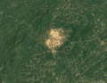
Satellite image showing the Copper Basin in 1984, before full recovery
-
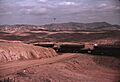
The Copper Basin in 1939, showing the barren landscape
-
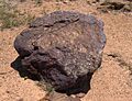
Copper ore found in the Copper Basin
-
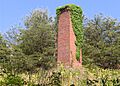
A chimney marking where copper was first found in 1843
-
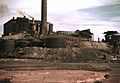
Copper mine and sulfuric acid plant in Copperhill, 1939
-
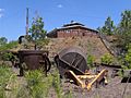
Mining machine parts and tools at the Burra Burra Mine site
