Decatur, Tennessee facts for kids
Quick facts for kids
Decatur, Tennessee
|
|
|---|---|

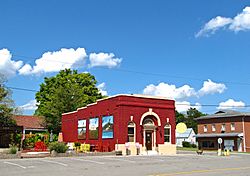
A building in Decatur, Tennessee.
|
|

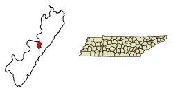
Location of Decatur in Meigs County, Tennessee.
|
|
| Country | United States |
| State | Tennessee |
| County | Meigs |
| Founded | 1836 |
| Incorporated | 1838 |
| Named for | Stephen Decatur |
| Area | |
| • Total | 3.80 sq mi (9.83 km2) |
| • Land | 3.80 sq mi (9.83 km2) |
| • Water | 0.00 sq mi (0.00 km2) |
| Elevation | 778 ft (237 m) |
| Population
(2020)
|
|
| • Total | 1,563 |
| • Density | 411.75/sq mi (158.99/km2) |
| Time zone | UTC-5 (Eastern (EST)) |
| • Summer (DST) | UTC-4 (EDT) |
| ZIP code |
37322
|
| Area code(s) | 423 |
| FIPS code | 47-19880 |
| GNIS feature ID | 1306311 |
Decatur (pronounced dih-KAY-ter) is a small town in Meigs County, Tennessee, in the United States. It is the main town and county seat of Meigs County. In 2020, about 1,563 people lived there.
Contents
History of Decatur
Decatur was started in May 1836. It became the main town for Meigs County, which was also created that same year. Two people, James Lillard and Leonard Brooks, gave 50 acres (about 0.2 square kilometers) of land to create the town.
The town is named after Commodore Stephen Decatur Jr.. He was a famous American naval officer in the early 1800s. He was known for his brave actions in wars like the First Barbary War, the Second Barbary War, and the War of 1812.
Geography and Location
Decatur is located in a part of Tennessee known as the Appalachian Ridge-and-Valley Province. This area has long, narrow ridges. Decatur sits at the western base of a ridge called No Pone Ridge.
Just west of town, the Tennessee River flows around a curve called Armstrong Bend. This part of the river is actually a large lake called Chickamauga Lake.
How to Get There
Decatur is located where two main roads meet:
- Tennessee State Route 30 connects Decatur to Athens to the east and Dayton to the west.
- Tennessee State Route 58 connects Decatur to Kingston to the north and Chattanooga to the south.
A major highway, Interstate 75, is about 15 miles (24 kilometers) east of Decatur. The town covers a total area of about 2.6 square miles (6.7 square kilometers), and all of it is land.
Population and People
The number of people living in Decatur has changed over the years. Here's how the population has grown:
| Historical population | |||
|---|---|---|---|
| Census | Pop. | %± | |
| 1870 | 99 | — | |
| 1880 | 175 | 76.8% | |
| 1890 | 313 | 78.9% | |
| 1910 | 165 | — | |
| 1920 | 142 | −13.9% | |
| 1930 | 158 | 11.3% | |
| 1940 | 205 | 29.7% | |
| 1950 | 235 | 14.6% | |
| 1960 | 681 | 189.8% | |
| 1970 | 698 | 2.5% | |
| 1980 | 1,069 | 53.2% | |
| 1990 | 1,361 | 27.3% | |
| 2000 | 1,395 | 2.5% | |
| 2010 | 1,598 | 14.6% | |
| 2020 | 1,563 | −2.2% | |
| Sources: | |||
People in Decatur (2020 Census)
In 2020, there were 1,563 people living in Decatur. These people lived in 586 households, and 416 of these were families.
Here's a look at the different groups of people living in Decatur based on the 2020 census:
| Race | Number | Percentage |
|---|---|---|
| White (non-Hispanic) | 1,429 | 91.43% |
| Black or African American (non-Hispanic) | 30 | 1.92% |
| Native American | 11 | 0.7% |
| Asian | 4 | 0.26% |
| Other/Mixed | 69 | 4.41% |
| Hispanic or Latino | 20 | 1.28% |
See also
 In Spanish: Decatur (Tennessee) para niños
 | Sharif Bey |
 | Hale Woodruff |
 | Richmond Barthé |
 | Purvis Young |

