Decatur County, Tennessee facts for kids
Quick facts for kids
Decatur County
|
||
|---|---|---|

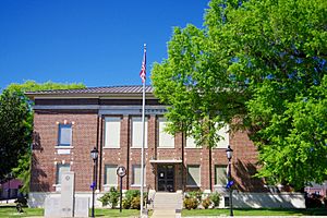
Decatur County Courthouse in Decaturville
|
||
|
||

Location within the U.S. state of Tennessee
|
||
 Tennessee's location within the U.S. |
||
| Country | ||
| State | ||
| Founded | November 1845 | |
| Named for | Stephen Decatur | |
| Seat | Decaturville | |
| Largest city | Parsons | |
| Area | ||
| • Total | 345 sq mi (890 km2) | |
| • Land | 334 sq mi (870 km2) | |
| • Water | 11 sq mi (30 km2) 3.2%% | |
| Population
(2020)
|
||
| • Total | 11,435 |
|
| • Density | 35/sq mi (14/km2) | |
| Time zone | UTC−6 (Central) | |
| • Summer (DST) | UTC−5 (CDT) | |
| Congressional district | 7th | |
Decatur County is a county located in the state of Tennessee, USA. It is found in the western part of Tennessee. As of the 2020 census, about 11,435 people lived there. The main town and county seat is Decaturville.
Contents
History of Decatur County
Why is it called Decatur County?
Decatur County is named after a brave naval hero. His name was Stephen Decatur, Jr.. He became famous for his leadership in several wars. These included the First Barbary War and the War of 1812. He was known for his achievements at sea.
How was the county formed?
The county was created in November 1845. It was formed from a part of Perry County. People living on the west side of the Tennessee River wanted their own county. So, the area west of the river became Decatur County.
Decatur County and the Civil War
During the American Civil War (1861-1865), many counties in West and Middle Tennessee supported the Confederate States. However, Decatur County was different. It mostly supported the Union.
On June 8, 1861, Tennessee voted on whether to leave the Union. Decatur County voted to stay in the Union. The vote was 550 to 310. It was one of only eight counties in West or Middle Tennessee to support the Union.
Geography of Decatur County
According to the U.S. Census Bureau, Decatur County covers about 345 square miles. Most of this area, 334 square miles, is land. The remaining 11 square miles, or 3.2%, is water.
Counties next to Decatur County
Decatur County shares borders with several other counties:
- Benton County (to the north)
- Perry County (to the east)
- Wayne County (to the southeast)
- Hardin County (to the south)
- Henderson County (to the west)
- Carroll County (to the northwest)
Protected areas in Decatur County
There are special protected natural areas in the county:
- Tennessee National Wildlife Refuge (part of it is in Decatur County)
- Carroll Cabin Barrens State Natural Area
- Cypress Pond Refuge
Population of Decatur County
| Historical population | |||
|---|---|---|---|
| Census | Pop. | %± | |
| 1850 | 6,003 | — | |
| 1860 | 6,276 | 4.5% | |
| 1870 | 7,772 | 23.8% | |
| 1880 | 8,498 | 9.3% | |
| 1890 | 8,995 | 5.8% | |
| 1900 | 10,439 | 16.1% | |
| 1910 | 10,093 | −3.3% | |
| 1920 | 10,198 | 1.0% | |
| 1930 | 10,106 | −0.9% | |
| 1940 | 10,261 | 1.5% | |
| 1950 | 9,442 | −8.0% | |
| 1960 | 8,324 | −11.8% | |
| 1970 | 9,457 | 13.6% | |
| 1980 | 10,857 | 14.8% | |
| 1990 | 10,472 | −3.5% | |
| 2000 | 11,731 | 12.0% | |
| 2010 | 11,757 | 0.2% | |
| 2020 | 11,435 | −2.7% | |
| U.S. Decennial Census 1790-1960 1900-1990 1990-2000 2010-2014 |
|||
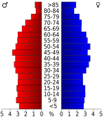
As of the 2020 census, there were 11,435 people living in Decatur County. There were 4,440 households and 3,059 families. Most of the people in the county are White (91.49%).
Communities in Decatur County
City
Towns
- Decaturville (This is the county seat)
- Scotts Hill (Part of this town is in Decatur County)
Unincorporated communities
These are smaller communities that are not officially cities or towns:
- Bath Springs
- Bible Hill
- Dunbar
- Holladay (Part of this community is in Decatur County)
- Hopewell
- Lick Skillet
- Perryville
- Sugar Tree
Images for kids
See also
 In Spanish: Condado de Decatur (Tennessee) para niños
 | Janet Taylor Pickett |
 | Synthia Saint James |
 | Howardena Pindell |
 | Faith Ringgold |


