Henderson County, Tennessee facts for kids
Quick facts for kids
Henderson County
|
||
|---|---|---|

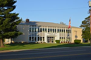
Henderson County Courthouse in Lexington
|
||
|
||

Location within the U.S. state of Tennessee
|
||
 Tennessee's location within the U.S. |
||
| Country | ||
| State | ||
| Founded | 1821 | |
| Named for | James Henderson | |
| Seat | Lexington | |
| Largest city | Lexington | |
| Area | ||
| • Total | 526 sq mi (1,360 km2) | |
| • Land | 520 sq mi (1,300 km2) | |
| • Water | 5.8 sq mi (15 km2) 1.1%% | |
| Population
(2020)
|
||
| • Total | 27,842 |
|
| • Density | 53/sq mi (20/km2) | |
| Time zone | UTC−6 (Central) | |
| • Summer (DST) | UTC−5 (CDT) | |
| Congressional district | 8th | |
Henderson County is a place in Tennessee, a state in the United States. In 2020, about 27,842 people lived here. The main town, or county seat, is Lexington. The county started in 1821. It was named after James Henderson, who was a soldier in the War of 1812.
Contents
History of Henderson County
Henderson County began in 1821. It was named after Lieutenant Colonel James Henderson, Jr. He was a soldier in the Tennessee State Militia. A militia is like a group of citizens who can be called to serve as soldiers. James Henderson died in 1814 near New Orleans during a fight with the British Army. He also fought in earlier wars, like the Creek War. This war happened around the same time as the War of 1812.
After the Battle of New Orleans, a large group of Tennessee soldiers set up their camp. This group was led by Major General William Carroll. They named their camp Camp Henderson to honor James Henderson.
General Carroll later became the Governor of Tennessee. His first time as governor started in the same year Henderson County was created. It's possible he suggested naming the new county after his brave officer, James Henderson.
The county seat, Lexington, was planned in 1822. Like many places in Tennessee, Henderson County was divided during the American Civil War. People in the western part of the county mostly supported the Confederates. This was because many large farms, called plantations, were in that area. People in the hilly eastern part of the county mostly supported the Union.
Geography of Henderson County
Henderson County covers about 526 square miles. Most of this area, about 520 square miles, is land. The rest, about 5.8 square miles, is water.
The county is on a special line called the Tennessee Valley Divide. Water on the east side of this line flows into the Tennessee River. Water on the west side flows into the Mississippi River. Important rivers here include the Beech River and the Forked Deer River.
Neighboring Counties
- Carroll County (north)
- Decatur County (east)
- Hardin County (southeast)
- Chester County (southwest)
- Madison County (west)
Protected Natural Areas
- Natchez Trace State Forest (part)
- Natchez Trace State Park (part)
Main Roads
 I-40
I-40 US 70
US 70 US 412
 SR 22
SR 22 SR 22A
 SR 104
People in Henderson County
| Historical population | |||
|---|---|---|---|
| Census | Pop. | %± | |
| 1830 | 8,748 | — | |
| 1840 | 11,875 | 35.7% | |
| 1850 | 13,164 | 10.9% | |
| 1860 | 14,491 | 10.1% | |
| 1870 | 14,217 | −1.9% | |
| 1880 | 17,430 | 22.6% | |
| 1890 | 16,336 | −6.3% | |
| 1900 | 18,117 | 10.9% | |
| 1910 | 17,030 | −6.0% | |
| 1920 | 18,436 | 8.3% | |
| 1930 | 17,655 | −4.2% | |
| 1940 | 19,220 | 8.9% | |
| 1950 | 17,173 | −10.7% | |
| 1960 | 16,115 | −6.2% | |
| 1970 | 17,291 | 7.3% | |
| 1980 | 21,390 | 23.7% | |
| 1990 | 21,844 | 2.1% | |
| 2000 | 25,522 | 16.8% | |
| 2010 | 27,769 | 8.8% | |
| 2020 | 27,842 | 0.3% | |
| U.S. Decennial Census 1790-1960 1900-1990 1990-2000 2010-2014 |
|||
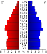
The 2020 United States census counted 27,842 people living in Henderson County. There were 10,711 households and 7,113 families.
Racial Makeup in 2020
| Race | Number of People | Percentage |
|---|---|---|
| White (not Hispanic) | 23,890 | 85.81% |
| Black or African American (not Hispanic) | 1,931 | 6.94% |
| Native American | 53 | 0.19% |
| Asian | 90 | 0.32% |
| Pacific Islander | 2 | 0.01% |
| Other/Mixed | 1,157 | 4.16% |
| Hispanic or Latino | 719 | 2.58% |
Transportation
The Beech River Regional Airport is an airport that anyone can use. It is about 5 miles northwest of Parsons, a city in Decatur County. The airport is located in Darden, Tennessee.
Communities in Henderson County
Cities
- Lexington (This is the county seat)
- Parkers Crossroads
Towns
- Sardis
- Scotts Hill (part of this town is in another county)
Census-Designated Places
These are areas that are like towns but are not officially governed as one.
Other Communities
These are smaller places that are not officially towns or cities.
See also
 In Spanish: Condado de Henderson (Tennessee) para niños
 | Laphonza Butler |
 | Daisy Bates |
 | Elizabeth Piper Ensley |


