Scotts Hill, Tennessee facts for kids
Quick facts for kids
Scotts Hill, Tennessee
|
||
|---|---|---|

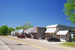
Businesses along SR 114
|
||
|
||

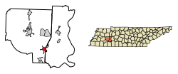
Location of Scotts Hill in Henderson County, Tennessee.
|
||
| Country | United States | |
| State | Tennessee | |
| Counties | Henderson, Decatur | |
| First settled | 1825 | |
| Area | ||
| • Total | 3.67 sq mi (9.49 km2) | |
| • Land | 3.67 sq mi (9.49 km2) | |
| • Water | 0.00 sq mi (0.00 km2) | |
| Elevation | 518 ft (158 m) | |
| Population
(2020)
|
||
| • Total | 877 | |
| • Density | 239.23/sq mi (92.37/km2) | |
| Time zone | UTC-6 (Central (CST)) | |
| • Summer (DST) | UTC-5 (CDT) | |
| ZIP code |
38374
|
|
| Area code(s) | 731 | |
| FIPS code | 47-66880 | |
| GNIS feature ID | 1300964 | |
Scotts Hill is a small town located in Decatur and Henderson counties in the state of Tennessee, United States. In 2020, about 877 people lived there.
The town got its name from Micajah Scott. He was an early settler and the first merchant to open a store in the area. His store was on a hill where the current Methodist Church now stands, which is how "Scotts Hill" got its name.
Contents
History of Scotts Hill
Scotts Hill was first settled in 1825 by Charles Austin. The town officially became a town in April 1917. Isiaac Wesley Patterson was the first mayor.
The town grew quickly because it was on a main stagecoach route. This route connected Clifton, Tennessee to Jackson, Tennessee.
- In May 1917, a strong tornado damaged the east side of Scotts Hill.
- Later that year, in October 1917, a fire destroyed many buildings. It burned down all twelve businesses and five homes.
Scotts Hill College opened in 1896 but closed around 1917. The town got its public water system in 1957.
Geography of Scotts Hill
Scotts Hill is located in the southeastern part of Henderson County. It also extends into the southwestern part of Decatur County. Its coordinates are 35°30′55″N 88°15′3″W / 35.51528°N 88.25083°W.
Tennessee State Route 100 runs through the town, just north of the center.
- It goes northeast about 8 miles (13 km) to Decaturville.
- It goes southwest about 22 miles (35 km) to Henderson.
The United States Census Bureau reports that Scotts Hill covers a total area of about 3.8 square miles (9.8 km2). All of this area is land.
Population Changes
| Historical population | |||
|---|---|---|---|
| Census | Pop. | %± | |
| 1920 | 123 | — | |
| 1930 | 235 | 91.1% | |
| 1950 | 299 | — | |
| 1960 | 298 | −0.3% | |
| 1970 | 548 | 83.9% | |
| 1980 | 668 | 21.9% | |
| 1990 | 594 | −11.1% | |
| 2000 | 894 | 50.5% | |
| 2010 | 984 | 10.1% | |
| 2020 | 877 | −10.9% | |
| Sources: | |||
In 2000, there were 894 people living in Scotts Hill. There were 376 households and 268 families. The town had about 357.9 inhabitants per square mile (138.2/km2) people per square mile.
About 31.6% of households had children under 18. About 56.1% were married couples. The average household had 2.36 people. The average family had 2.81 people.
The population was spread out by age:
- 24.6% were under 18 years old.
- 6.9% were from 18 to 24 years old.
- 26.0% were from 25 to 44 years old.
- 25.2% were from 45 to 64 years old.
- 17.3% were 65 years or older.
The average age in the town was 39 years.
Education in Scotts Hill
Scotts Hill Elementary School serves students from pre-kindergarten through eighth grade. Older students attend Scotts Hill High School. This high school is located in Reagan, Tennessee, a nearby community.
See also
In Spanish: Scotts Hill (Tennessee) para niños
 | Misty Copeland |
 | Raven Wilkinson |
 | Debra Austin |
 | Aesha Ash |


