Carroll County, Tennessee facts for kids
Quick facts for kids
Carroll County
|
|
|---|---|

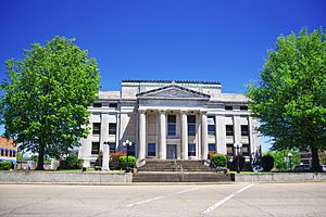
Carroll County Courthouse in Huntingdon
|
|

Location within the U.S. state of Tennessee
|
|
 Tennessee's location within the U.S. |
|
| Country | |
| State | |
| Founded | November 7, 1821 |
| Named for | William Carroll |
| Seat | Huntingdon |
| Largest city | McKenzie |
| Area | |
| • Total | 600 sq mi (2,000 km2) |
| • Land | 599 sq mi (1,550 km2) |
| • Water | 0.8 sq mi (2 km2) 0.1%% |
| Population
(2020)
|
|
| • Total | 28,440 |
| • Density | 48/sq mi (19/km2) |
| Time zone | UTC−6 (Central) |
| • Summer (DST) | UTC−5 (CDT) |
| Congressional district | 8th |
Carroll County is a special area called a county in the western part of Tennessee, a U.S. state. In 2020, about 28,440 people lived here. The main town, or county seat, where the county government is, is Huntingdon. Carroll County was created on November 7, 1821. It was named after William Carroll, who was a governor of Tennessee.
Contents
Exploring Carroll County's Land and Water
Carroll County covers about 600 square miles. Most of this area, 599 square miles, is land. Only a tiny part, about 0.8 square miles, is water.
The Big Carroll County Lake
A very important water area in Carroll County is the Carroll County Thousand Acre Recreational Lake. Many people who live in the county have made this lake their home for a long time.
In 2022, there was an idea to change the lake's name. But the people living in the county wanted to keep the original name. So, it is still called the Carroll County Thousand Acre Recreational Lake.
Neighboring Counties Around Carroll County
Carroll County shares its borders with several other counties:
- Henry County (to the northeast)
- Benton County (to the east)
- Decatur County (to the southeast)
- Henderson County (to the south)
- Madison County (to the southwest)
- Gibson County (to the west)
- Weakley County (to the northwest)
Protected Natural Areas in Carroll County
Some parts of Carroll County are protected to keep nature safe. These areas include:
- Harts Mill Wetland Wildlife Management Area (a part of it)
- Jarrell Switch Refuge
- Natchez Trace State Forest (a part of it)
- Natchez Trace State Park (a part of it)
Who Lives in Carroll County?
| Historical population | |||
|---|---|---|---|
| Census | Pop. | %± | |
| 1830 | 9,397 | — | |
| 1840 | 12,362 | 31.6% | |
| 1850 | 15,967 | 29.2% | |
| 1860 | 17,437 | 9.2% | |
| 1870 | 19,447 | 11.5% | |
| 1880 | 22,103 | 13.7% | |
| 1890 | 23,630 | 6.9% | |
| 1900 | 24,250 | 2.6% | |
| 1910 | 23,971 | −1.2% | |
| 1920 | 24,361 | 1.6% | |
| 1930 | 26,132 | 7.3% | |
| 1940 | 25,978 | −0.6% | |
| 1950 | 26,553 | 2.2% | |
| 1960 | 23,476 | −11.6% | |
| 1970 | 25,741 | 9.6% | |
| 1980 | 28,285 | 9.9% | |
| 1990 | 27,514 | −2.7% | |
| 2000 | 29,475 | 7.1% | |
| 2010 | 28,522 | −3.2% | |
| 2020 | 28,440 | −0.3% | |
| U.S. Decennial Census 1790-1960 1900-1990 1990-2000 2010-2014 |
|||
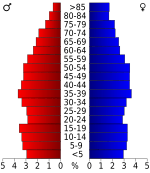
In 2020, the census showed that 28,440 people lived in Carroll County. There were 10,962 households, which are groups of people living together. Also, there were 7,451 families living in the county.
Getting Around Carroll County
The Carroll County Airport helps people travel by air. It is a public airport owned by the county. You can find it about 4 miles northwest of Huntingdon, the county seat.
News and Entertainment in Carroll County
Carroll County has its own ways for people to get news and listen to music.
Local Radio Stations
- WRQR-FM 105.5
- WTPR-AM 710
- WTPR-FM 101.7
- WEIO "100.9 The Farm"
- WHDM 1440-AM 98.9-FM
- WAJJ 89.3 FM Christian Radio "The J"
Local Newspapers
- Carroll County News-Leader
- The McKenzie Banner
- Tennessee Magnet Publications
Towns and Communities in Carroll County
Carroll County has several towns and communities where people live and work.
Cities in Carroll County
- McKenzie (a small part of this city is also in Henry County and Weakley County)
Towns in Carroll County
- Atwood
- Bruceton
- Clarksburg
- Hollow Rock
- Huntingdon (this is the county seat)
- McLemoresville
- Trezevant
Smaller Communities (Unincorporated)
These are smaller places that are not officially cities or towns:
See also
 In Spanish: Condado de Carroll (Tennessee) para niños
 | Anna J. Cooper |
 | Mary McLeod Bethune |
 | Lillie Mae Bradford |


