Cumberland County, Tennessee facts for kids
Quick facts for kids
Cumberland County
|
||
|---|---|---|
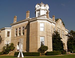
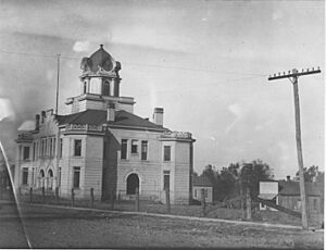
Cumberland County Courthouse in Crossville
|
||
|
||

Location within the U.S. state of Tennessee
|
||
 Tennessee's location within the U.S. |
||
| Country | ||
| State | ||
| Founded | November 16, 1855 | |
| Named for | Cumberland Mountains | |
| Seat | Crossville | |
| Largest city | Crossville | |
| Area | ||
| • Total | 685 sq mi (1,770 km2) | |
| • Land | 681 sq mi (1,760 km2) | |
| • Water | 3.8 sq mi (10 km2) 0.6%% | |
| Population
(2020)
|
||
| • Total | 61,145 |
|
| • Density | 82/sq mi (32/km2) | |
| Time zone | UTC−6 (Central) | |
| • Summer (DST) | UTC−5 (CDT) | |
| Congressional district | 6th | |
Cumberland County is a county in the state of Tennessee. In 2020, about 61,145 people lived there. The main town and county seat is Crossville. Cumberland County is part of the Crossville, TN area.
Contents
History of Cumberland County
Cumberland County was created in 1856. It was formed from parts of several other counties. These included Bledsoe, Roane, and Morgan counties.
During the American Civil War, people in the county were divided. Some supported the Union (the North). Others supported the Confederacy (the South).
In 1787, the government of North Carolina wanted to improve a path. This path was called Avery's Trace. It went from North Carolina through Knoxville to Nashville. This path was made into a wagon road. But it was still very rough and muddy. Wagons often had trouble on steep hills.
Cumberland County was also important for making gunpowder. This was because of a saltpeter mine. Saltpeter is a key ingredient in gunpowder. It was found in a place called Grassy Cove Saltpeter Cave. People would dig up earth from the cave. Then they would wash it to get the saltpeter.
Richard Green Waterhouse explored this cave in 1812. Later, in 1859, Dicky Mathews started making gunpowder there. Sadly, his son died in an explosion at a nearby spring. This cave is very large. You can still see signs of the old mining work.
In the 1930s, the government started a program. It was part of the New Deal. This program was called the Subsistence Homesteads Division. It helped families who were struggling. They built houses and gave land to 250 families near Crossville. Cumberland Mountain State Park was also built as part of this project.
Geography of Cumberland County
Cumberland County covers about 685 square miles. Most of this is land, with a small amount of water. It is the fourth largest county in Tennessee. The county sits on top of the Cumberland Plateau. The southern part of the Cumberland Mountains are also in the county. These are known as the Crab Orchard Mountains.
The county has many interesting karst formations. These are landforms made when water dissolves rock. One famous example is Grassy Cove. This is a huge, bowl-shaped area. It is about 3 miles wide and 5 miles long. All the water that flows into Grassy Cove goes underground. It then comes out 4 miles away to form the Sequatchie River.
The Tennessee Divide runs through the county. This is where the water flows in different directions. Some water flows into the Cumberland River. Other water flows into the Tennessee River. The Caney Fork river starts west of this divide. The Obed River starts east of it.
Neighboring Counties
- Fentress County (north)
- Morgan County (northeast)
- Roane County (east)
- Rhea County (southeast)
- Bledsoe County (south)
- Van Buren County (southwest)
- White County (west)
- Putnam County (northwest)
Protected Natural Areas
- Obed Wild and Scenic River (part)
State Parks and Forests
- Bledsoe State Forest (part)
- Catoosa Wildlife Management Area (part)
- Cumberland Mountain State Park
- Cumberland Trail (part)
- Keyes-Harrison Wildlife Management Area
- Luper Mountain Wildlife Management Area
- Mount Roosevelt Wildlife Management Area (part)
- Ozone Falls State Natural Area
People in Cumberland County
| Historical population | |||
|---|---|---|---|
| Census | Pop. | %± | |
| 1860 | 3,460 | — | |
| 1870 | 3,461 | 0.0% | |
| 1880 | 4,538 | 31.1% | |
| 1890 | 5,376 | 18.5% | |
| 1900 | 8,311 | 54.6% | |
| 1910 | 9,327 | 12.2% | |
| 1920 | 10,094 | 8.2% | |
| 1930 | 11,440 | 13.3% | |
| 1940 | 15,592 | 36.3% | |
| 1950 | 18,877 | 21.1% | |
| 1960 | 19,135 | 1.4% | |
| 1970 | 20,733 | 8.4% | |
| 1980 | 28,676 | 38.3% | |
| 1990 | 34,736 | 21.1% | |
| 2000 | 46,802 | 34.7% | |
| 2010 | 56,053 | 19.8% | |
| 2020 | 61,145 | 9.1% | |
| U.S. Decennial Census 1790-1960 1900-1990 1990-2000 2010-2014 |
|||
2020 Census Information
| Race | Number | Percentage |
|---|---|---|
| White (not Hispanic) | 56,313 | 92.1% |
| Black or African American (not Hispanic) | 299 | 0.49% |
| Native American | 130 | 0.21% |
| Asian | 366 | 0.6% |
| Pacific Islander | 12 | 0.02% |
| Other/Mixed | 2,089 | 3.42% |
| Hispanic or Latino | 1,936 | 3.17% |
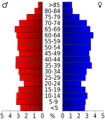
In 2020, there were 61,145 people living in Cumberland County. There were 25,801 households.
2010 Census Information
In 2010, there were 56,053 people in the county. The population density was about 82 people per square mile. Most people (96.08%) were White. About 2.3% of the people were Hispanic or Latino.
The largest ancestry groups were German (15%), American (14.8%), Irish (12.9%), and English (11.8%).
Education in Cumberland County
The Cumberland County School District manages the schools. There are two high schools and nine elementary schools. There is also one charter school. Some of the schools are Cumberland County & Stone Memorial High Schools.
Communities in Cumberland County
Cities
- Crab Orchard
- Crossville (the main town)
Town
Other Communities
- Bowman
- Fairfield Glade
- Lake Tansi
- Mayland
Small Villages and Areas
- Westel, Tennessee
See also
 In Spanish: Condado de Cumberland (Tennessee) para niños
 | James B. Knighten |
 | Azellia White |
 | Willa Brown |


