Fentress County, Tennessee facts for kids
Quick facts for kids
Fentress County
|
|
|---|---|

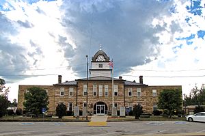
Fentress County Courthouse in Jamestown
|
|

Location within the U.S. state of Tennessee
|
|
 Tennessee's location within the U.S. |
|
| Country | |
| State | |
| Founded | November 28, 1823 |
| Named for | James Fentress, state legislator |
| Seat | Jamestown |
| Largest city | Jamestown |
| Area | |
| • Total | 499 sq mi (1,290 km2) |
| • Land | 499 sq mi (1,290 km2) |
| • Water | 0.3 sq mi (0.8 km2) 0.06%% |
| Population
(2020)
|
|
| • Total | 18,489 |
| • Density | 36/sq mi (14/km2) |
| Time zone | UTC−6 (Central) |
| • Summer (DST) | UTC−5 (CDT) |
| Congressional district | 6th |
Fentress County is a county in the state of Tennessee. It is located in the eastern part of the state. In 2020, about 18,489 people lived there. The main town and county seat (where the county government is) is Jamestown.
Contents
History of Fentress County
Fentress County was created on November 28, 1823. It was formed from parts of three other counties: Morgan, Overton, and White. The county was named after James Fentress (1763–1843). He was an important person in Tennessee politics. He served as the speaker of the state house.
Saltpeter Mining
Fentress County was once home to several saltpeter mines. Saltpeter is a key ingredient used to make gunpowder. It was found in caves. Workers would collect earth from these caves and process it to get the saltpeter.
One of the biggest mines was in York Cave. It had 25 large vats for processing the earth. This cave was used for mining during the American Civil War. Buffalo Cave, near Jamestown, was another large mine. It had 12 vats. These mines might also have been used during the War of 1812.
The Civil War Era
Before the American Civil War, Tennessee had to decide if it would leave the United States. The two representatives from Fentress County voted to leave. However, when the people of Fentress County voted on June 8, 1861, most of them (651 to 128) voted to stay in the Union. This was interesting because earlier, in February 1861, Fentress County had voted by a very small margin to hold a meeting about leaving the Union.
Alvin York, War Hero
Alvin York (1887–1964) was a famous hero from World War I. He was born and lived in Fentress County. He became famous for his bravery during the Meuse-Argonne Offensive. In 1924, he started the Alvin C. York Agricultural Institute in Jamestown. Today, his home and farm are part of the Sgt. Alvin C. York State Historic Park in Pall Mall.
Geography of Fentress County
Fentress County covers about 499 square miles (1,292 square kilometers). Most of this area is land. Only a very small part is water.
The county includes part of the Dale Hollow Reservoir. Rivers like the Obey and Cumberland flow through the area.
Fentress County is the easternmost county in the United States that uses the Central Time Zone. This means that counties just to its east are in a different time zone.
Neighboring Counties
Fentress County shares borders with several other counties:
- Pickett County (north)
- Scott County (east, on the Eastern Time Zone border)
- Morgan County (southeast, on the Eastern Time Zone border)
- Cumberland County (south)
- Overton County (west)
- Putnam County (southwest)
Protected Natural Areas
Fentress County has parts of several important natural areas:
- Big South Fork National River and Recreation Area (a national park area)
- Catoosa Wildlife Management Area (a place for wildlife)
- Colditz Cove State Natural Area
- Pickett State Forest (a state forest)
- Pogue Creek Canyon State Natural Area
- Scott State Forest (another state forest)
- Sgt. Alvin C. York State Historic Park (a park about Alvin York)
- Skinner Mountain Wildlife Management Area
- Twin Arches State Natural Area
Population and People
| Historical population | |||
|---|---|---|---|
| Census | Pop. | %± | |
| 1830 | 2,748 | — | |
| 1840 | 3,550 | 29.2% | |
| 1850 | 4,454 | 25.5% | |
| 1860 | 5,054 | 13.5% | |
| 1870 | 4,717 | −6.7% | |
| 1880 | 5,941 | 25.9% | |
| 1890 | 5,226 | −12.0% | |
| 1900 | 6,106 | 16.8% | |
| 1910 | 7,446 | 21.9% | |
| 1920 | 10,435 | 40.1% | |
| 1930 | 11,036 | 5.8% | |
| 1940 | 14,262 | 29.2% | |
| 1950 | 14,917 | 4.6% | |
| 1960 | 13,288 | −10.9% | |
| 1970 | 12,593 | −5.2% | |
| 1980 | 14,826 | 17.7% | |
| 1990 | 14,669 | −1.1% | |
| 2000 | 16,625 | 13.3% | |
| 2010 | 17,958 | 8.0% | |
| 2020 | 18,489 | 3.0% | |
| U.S. Decennial Census 1790-1960 1900-1990 1990-2000 2010-2014 |
|||
2020 Census Information
| Race | Number | Percentage |
|---|---|---|
| White (not Hispanic) | 17,541 | 94.87% |
| Black or African American (not Hispanic) | 25 | 0.14% |
| Native American | 26 | 0.14% |
| Asian | 33 | 0.18% |
| Other/Mixed | 548 | 2.96% |
| Hispanic or Latino | 316 | 1.71% |
In 2020, there were 18,489 people living in Fentress County. There were 7,443 households and 4,929 families.
2010 Census Information
In 2010, the county had 17,959 people. There were 7,326 households. The population density was about 36 people per square mile. Most people (98.1%) identified as White.
About 23.1% of households had children under 18 years old. Many households (57.3%) were married couples living together. The average household had 2.46 people. The average family had 2.94 people.
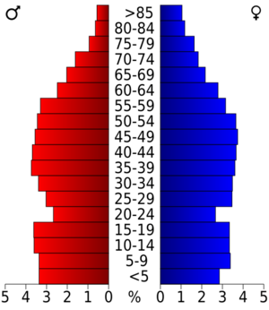
The population was spread out by age. About 24.2% were under 18. The median age was 38 years old. This means half the people were younger than 38 and half were older. For every 100 females, there were about 96 males.
Towns and Communities
Fentress County has several towns and smaller communities.
Cities
Census-designated places
These are areas that are like towns but are not officially incorporated as cities.
Unincorporated communities
These are smaller communities without their own local government.
See also
 In Spanish: Condado de Fentress para niños
 | Jackie Robinson |
 | Jack Johnson |
 | Althea Gibson |
 | Arthur Ashe |
 | Muhammad Ali |


