Jamestown, Tennessee facts for kids
Quick facts for kids
Jamestown, Tennessee
|
|
|---|---|

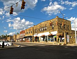
Buildings along Main Street
|
|

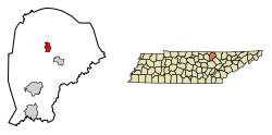
Location of Jamestown in Fentress County, Tennessee.
|
|
| Country | United States |
| State | Tennessee |
| County | Fentress |
| Founded | 1823 |
| Incorporated | 1837 |
| Named for | James Fentress |
| Area | |
| • Total | 3.11 sq mi (8.07 km2) |
| • Land | 3.11 sq mi (8.07 km2) |
| • Water | 0.00 sq mi (0.00 km2) |
| Elevation | 1,716 ft (523 m) |
| Population
(2020)
|
|
| • Total | 1,935 |
| • Density | 621.39/sq mi (239.90/km2) |
| Time zone | UTC-6 (Central (CST)) |
| • Summer (DST) | UTC-5 (CDT) |
| ZIP code |
38556
|
| Area code(s) | 931 |
| FIPS code | 47-37780 |
| GNIS feature ID | 1289287 |
Jamestown is a city in Tennessee, located in Fentress County. It is the main town, or county seat, of Fentress County. In 2020, about 1,935 people lived there.
Contents
History of Jamestown
How Jamestown Was Founded
Jamestown was started in 1823 to be the main town for Fentress County. It became an official city in 1837. Both the county and the city are named after James Fentress, a local politician. He helped make Fentress County a new county.
Early Days and Mark Twain's Family Connection
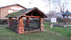
Before Jamestown was built, the area was called "Sand Springs." This was because of many natural springs that bubbled up from the ground. One of these springs is still in Mark Twain City Park today. It provided water for the family of John M. Clemens. He was the father of the famous writer Samuel L. Clemens, also known as Mark Twain. John Clemens was the first court clerk in the area. He also designed the first courthouse and jail.
Jamestown During the Civil War
During the American Civil War, Fentress County had people fighting on both sides. Four groups joined the Confederate Army, and three groups joined the Union Army. Local leaders like "Tinker Dave" Beaty (for the Union) and Champ Ferguson (for the Confederates) led their own groups. These groups often fought each other.
World War I Hero: Alvin York
World War I hero Sgt. Alvin C. York grew up in Fentress County. He built the Alvin C. York Agricultural Institute, which is a high school in Jamestown. It is one of only four state-funded schools in Tennessee.
Geography and Location
Where is Jamestown Located?
Jamestown is located at 36°25′45″N 84°55′57″W / 36.42917°N 84.93250°W. The city is on the western edge of the Cumberland Plateau. This is a large, flat area of land that is higher than the surrounding land. Streams in the eastern part of the city flow into the Big South Fork of the Cumberland River. Streams in the western part flow into the Obey River.
Major Roads and Nearby Areas
Jamestown is at the meeting point of two important roads. U.S. Route 127 connects the city to Crossville to the south and Kentucky to the north. State Route 52 connects Jamestown to Livingston to the west and Allardt to the southeast. Another road, State Route 154, links the Jamestown area to Pickett State Park.
City Size
According to the United States Census Bureau, Jamestown covers about 2.9 square miles (7.5 square kilometers) of land. There is no water area within the city limits.
Climate in Jamestown
Jamestown has a climate with warm summers and mild winters. It gets a good amount of rain throughout the year.
| Climate data for Jamestown, Tennessee, 1991–2020 normals, extremes 1969–2022 | |||||||||||||
|---|---|---|---|---|---|---|---|---|---|---|---|---|---|
| Month | Jan | Feb | Mar | Apr | May | Jun | Jul | Aug | Sep | Oct | Nov | Dec | Year |
| Record high °F (°C) | 74 (23) |
74 (23) |
84 (29) |
87 (31) |
89 (32) |
103 (39) |
101 (38) |
100 (38) |
95 (35) |
92 (33) |
81 (27) |
75 (24) |
103 (39) |
| Mean maximum °F (°C) | 64.5 (18.1) |
68.5 (20.3) |
75.8 (24.3) |
82.8 (28.2) |
85.0 (29.4) |
89.5 (31.9) |
90.4 (32.4) |
90.0 (32.2) |
88.0 (31.1) |
82.2 (27.9) |
74.6 (23.7) |
65.4 (18.6) |
91.8 (33.2) |
| Mean daily maximum °F (°C) | 44.6 (7.0) |
48.6 (9.2) |
57.8 (14.3) |
67.5 (19.7) |
74.7 (23.7) |
81.8 (27.7) |
84.3 (29.1) |
84.0 (28.9) |
78.1 (25.6) |
68.8 (20.4) |
57.3 (14.1) |
48.0 (8.9) |
66.3 (19.1) |
| Daily mean °F (°C) | 34.7 (1.5) |
37.9 (3.3) |
46.0 (7.8) |
54.8 (12.7) |
63.6 (17.6) |
71.1 (21.7) |
74.1 (23.4) |
73.5 (23.1) |
67.0 (19.4) |
56.2 (13.4) |
45.6 (7.6) |
38.2 (3.4) |
55.2 (12.9) |
| Mean daily minimum °F (°C) | 24.9 (−3.9) |
27.3 (−2.6) |
34.2 (1.2) |
42.2 (5.7) |
52.5 (11.4) |
60.4 (15.8) |
63.9 (17.7) |
63.1 (17.3) |
55.9 (13.3) |
43.7 (6.5) |
34.0 (1.1) |
28.3 (−2.1) |
44.2 (6.8) |
| Mean minimum °F (°C) | 3.3 (−15.9) |
8.6 (−13.0) |
17.8 (−7.9) |
26.7 (−2.9) |
34.9 (1.6) |
48.7 (9.3) |
54.3 (12.4) |
53.8 (12.1) |
42.7 (5.9) |
28.3 (−2.1) |
18.1 (−7.7) |
11.5 (−11.4) |
1.5 (−16.9) |
| Record low °F (°C) | −8 (−22) |
−7 (−22) |
7 (−14) |
16 (−9) |
27 (−3) |
42 (6) |
49 (9) |
46 (8) |
32 (0) |
23 (−5) |
11 (−12) |
−3 (−19) |
−8 (−22) |
| Average precipitation inches (mm) | 5.03 (128) |
4.86 (123) |
5.52 (140) |
5.46 (139) |
5.31 (135) |
5.52 (140) |
5.29 (134) |
4.64 (118) |
4.00 (102) |
3.18 (81) |
4.11 (104) |
6.26 (159) |
59.18 (1,503) |
| Average snowfall inches (cm) | 3.2 (8.1) |
5.7 (14) |
4.8 (12) |
0.1 (0.25) |
0.0 (0.0) |
0.0 (0.0) |
0.0 (0.0) |
0.0 (0.0) |
0.0 (0.0) |
0.0 (0.0) |
0.3 (0.76) |
4.8 (12) |
18.9 (47.11) |
| Average precipitation days (≥ 0.01 in) | 13.8 | 12.7 | 13.3 | 12.2 | 12.7 | 12.4 | 11.6 | 9.8 | 9.0 | 8.9 | 10.3 | 13.7 | 140.4 |
| Average snowy days (≥ 0.1 in) | 3.5 | 3.0 | 1.9 | 0.2 | 0.0 | 0.0 | 0.0 | 0.0 | 0.0 | 0.0 | 0.4 | 2.5 | 11.5 |
| Source 1: NOAA | |||||||||||||
| Source 2: National Weather Service | |||||||||||||
Population and Demographics
How Many People Live in Jamestown?
| Historical population | |||
|---|---|---|---|
| Census | Pop. | %± | |
| 1880 | 86 | — | |
| 1890 | 84 | −2.3% | |
| 1930 | 857 | — | |
| 1940 | 1,230 | 43.5% | |
| 1950 | 2,115 | 72.0% | |
| 1960 | 1,727 | −18.3% | |
| 1970 | 1,899 | 10.0% | |
| 1980 | 2,364 | 24.5% | |
| 1990 | 1,862 | −21.2% | |
| 2000 | 1,839 | −1.2% | |
| 2010 | 1,959 | 6.5% | |
| 2020 | 1,935 | −1.2% | |
| Sources: | |||
The population of Jamestown has changed over the years. In 2020, the city had 1,935 residents. There were 875 households and 396 families living in the city at that time.
Jamestown's Population Makeup (2020)
| Race | Number | Percentage |
|---|---|---|
| White (non-Hispanic) | 1,792 | 92.61% |
| Black or African American (non-Hispanic) | 8 | 0.41% |
| Native American | 6 | 0.31% |
| Asian | 10 | 0.52% |
| Other/Mixed | 72 | 3.72% |
| Hispanic or Latino | 47 | 2.43% |
Most of the people living in Jamestown are White. There are also smaller groups of Black or African American, Native American, and Asian residents. Some people identify with more than one race. About 2.43% of the population is of Hispanic or Latino background.
Local Media and News
Jamestown has several radio stations: WCLC-FM/105.1, WDEB/1500, and WDEB-FM/103.9. There is also a low-power FM station, WSAB-LP/92.5. The local newspaper is called the Fentress Courier. It is published every Wednesday in print and online.
Community Events
Jamestown is famous for being the starting point of the World's Longest Yardsale. This event is also known as the 127 Corridor Sale.
See also
 In Spanish: Jamestown (Tennessee) para niños
 | Frances Mary Albrier |
 | Whitney Young |
 | Muhammad Ali |


