
Big South Fork of the Cumberland River facts for kids
Quick facts for kids Big South Fork of the Cumberland River |
|
|---|---|
 |
|

Location of the river mouth in Kentucky
|
|
| Country | United States |
| Physical characteristics | |
| Main source | Confluence of the New River and the Clear Fork in Scott County, Tennessee. 1,004 ft (306 m) |
| River mouth | Confluence with the Cumberland River near Burnside, Kentucky 722 ft (220 m) 36°58′01″N 84°36′19″W / 36.967083°N 84.605291°W |
| Length | 76 miles (122 km) |
The Big South Fork of the Cumberland River is a 76-mile-long (122 km) river that flows through Tennessee and Kentucky in the United States. It's an important part of the Cumberland Plateau and flows into the larger Cumberland River. This river is also the main feature of the Big South Fork National River and Recreation Area, a special park.
Contents
Exploring the Big South Fork River
The Big South Fork River starts where two other rivers meet: the New River and the Clear Fork. This meeting point is in Scott County, Tennessee. From there, the river flows mostly north. It eventually reaches Lake Cumberland in McCreary County, Kentucky, near the town of Burnside.
The Big South Fork is the third largest river that flows into the Cumberland River. About 37 miles (60 km) of the river flows freely before it reaches the waters of Lake Cumberland.
River's Journey and Landscape
The land around the river is very rugged near where it begins. Here, the hills can be as high as 1,900 feet (580 m). The area has many narrow gorges and valleys filled with large rocks that have fallen from cliffs. You can also see cool rock formations like natural arches, flat-topped mesas, and rock shelters.
As the river flows north, the land becomes less rugged. The hills are then between 200 feet (61 m) and 300 feet (91 m) high.
How the River Gets Its Water

The Big South Fork gets its water from a large area called a drainage basin. This basin is made of Carboniferous rock found in the Cumberland Plateau. The Big South Fork and its smaller rivers (tributaries) collect water from an area between 1,123 square miles (2,910 km2) and 1,382 square miles (3,580 km2). About 17% of this area is part of the National Recreation Area.
The river's water flow changes throughout the year. The most water recorded flowing in the river was 93,200 cu ft/s (2,640 m3/s). The least was 11 cu ft/s (0.31 m3/s). On average, the river flows at 1,760 cu ft/s (50 m3/s). About half of the river's yearly water flow happens from January to March. The lowest water levels are usually in September and October.
The water in the river basin drops from about 1,250 feet (380 m) above sea level to 723 feet (220 m) where it meets the Cumberland River.
Main Rivers Joining the Big South Fork
Many smaller rivers and creeks flow into the Big South Fork. Some of the major ones include:
- New River
- Clear Fork River
- North Whiteoak Creek
- Pine Creek
- Station Camp Creek
- Parch Corn Creek
- No Business Creek
- Williams Creek
- Troublesome Creek
- Bear Creek
- Roaring Paunch Creek
- Rock Creek
- Wolf Creek
- Kogar Creek
The water quality in the Big South Fork is usually good. However, it can be affected by water from old mines, logging, and poor roads. Different groups have worked to clean up and protect the river. Both Tennessee and Kentucky have named their parts of the Big South Fork as "Outstanding National Resource Waters."
History of the Big South Fork Area
People have likely visited the area around the Big South Fork for thousands of years, even before colonial times. However, it's not clear if anyone lived there permanently in ancient times. In 2005, a report estimated there could be as many as 10,000 old sites where people once lived or visited. These sites are split evenly between those from before and after Europeans arrived.
The first lasting European settlement in the area was probably in 1769. By 1798, the Treaty of Tellico officially moved the native Cherokee people out of the river basin. The land wasn't great for agriculture, so many settlers passed it by. Later, in the 1880s, a colony called Rugby, Tennessee was started, but it didn't last.
Blue Heron Mining Town

The mining town of Blue Heron, Kentucky, was built in 1937 right next to the Big South Fork. It was a coal mining community that operated until 1962. After it was abandoned, the site was rebuilt in the 1980s. Today, it's an outdoor museum where you can learn about its history.
Big South Fork National River and Recreation Area
The Big South Fork National River and Recreation Area was created by the United States Congress in 1974. The main goal was to protect this special area. This includes its unique culture, history, geology, animals, plants, and beautiful scenery. It also aims to keep the Big South Fork River flowing naturally. The park was officially dedicated on August 25, 1991.
Animals and Plants of the Big South Fork
.jpg)
The Big South Fork and its surrounding area are home to many different kinds of plants and animals. The land has likely had plants growing on it continuously for over 10,000 years! You can find different habitats here, like flat areas near the river (called floodplains), sheltered valleys (coves), and steep, narrow valleys (ravines).
The area is home to many species, including:
- Between 68 and 81 types of fish
- 23 types of mussels
- Up to 215 types of macro invertebrates (small creatures without backbones)
Animal Life in the River and Forests
Some of the fish you might find in the river include Channel catfish, Walleye, Muskellunge, White bass, Rock bass, and Longear sunfish.
The forests provide food like seeds, berries, nuts, and twigs. This helps animals like the Ruffed grouse, Wild turkey, and eastern gray squirrel to live here. Birds like the Red-eyed vireo, Hooded warbler, and American redstart also live in the trees. Smaller mammals like the Smoky shrew, Eastern mole, Eastern woodrat, and White-footed mouse also call this area home. These smaller animals then become food for predatory birds like the Barred owl and Red-shouldered hawk.
In the 1990s, 30 black bears were brought to the river basin from the Great Smoky Mountains National Park. By 2013, it was estimated that about 245 bears lived in the area.
Plant Life in the Area
The plants along the river and in the basin can be divided into two main groups: those on the flat plateau and those in the ravines. You'll find mixed oak forests and other types of mixed forests.
Forests of Sugar maple, beech, and Yellow birch grow on low, moist slopes. Eastern hemlock trees with Rhododendron maximum plants underneath grow in the sheltered coves along streams. You can also find different types of pine trees.
Because of logging in the mid-1900s, most of the forests you see today are "second" or "third growth." This means they have grown back after being cut down.
Whitewater Adventures
Whitewater rafting and kayaking are popular activities on the Big South Fork, especially in the spring. You can find river runs that are from 4.8 miles (7.7 km) to 27 miles (43 km) long. The difficulty of these runs ranges from Class I (easy) to Class IV (difficult) on the international scale of river difficulty.
The most popular runs are those upstream from Leatherwood Ford. These range from 8.5 miles (13.7 km) to 15.5 miles (24.9 km) long. Their difficulty can be anywhere from Class I to Class IV, depending on where you start. The National Park Service suggests that the river flow should be at least 800 cfs (cubic feet per second) for rafting. For safe rafting, the flow should not be more than 10,000 cfs.
As you go downstream from where the New River and Clear Fork meet, towards Lake Cumberland, you'll find several named rapids. These are:
- Double Falls
- Washing Machine
- The Ell
- Rion’s Eddy
- Jake’s Hold
- O&W Rapid
- Angel Falls
- Big Shoals
- Devil’s Jump
Images for kids
-
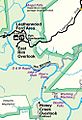
Excerpt from an NPS map, showing the confluence (bottom right), rapids up to Leatherwood Ford, and Angel Falls downstream (northward)
.jpg)
