McCreary County, Kentucky facts for kids
Quick facts for kids
McCreary County
|
|
|---|---|

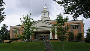
McCreary County courthouse in Whitley City
|
|

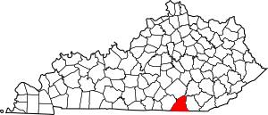
Location within the U.S. state of Kentucky
|
|
 Kentucky's location within the U.S. |
|
| Country | |
| State | |
| Founded | March 12, 1912 |
| Named for | James B. McCreary |
| Seat | Whitley City |
| Largest community | Pine Knot |
| Area | |
| • Total | 431 sq mi (1,120 km2) |
| • Land | 427 sq mi (1,110 km2) |
| • Water | 4.1 sq mi (11 km2) 1.0%% |
| Population
(2020)
|
|
| • Total | 16,888 |
| • Estimate
(2023)
|
17,050 |
| • Density | 39.18/sq mi (15.129/km2) |
| Time zone | UTC−5 (Eastern) |
| • Summer (DST) | UTC−4 (EDT) |
| Congressional district | 5th |
McCreary County is a county in the state of Kentucky. In 2020, about 16,888 people lived there. Its main town, or county seat, is Whitley City. The county is named after James B. McCreary. He was a soldier and served as Governor of Kentucky twice. McCreary County was created and named in his honor during his second term as governor.
Contents
History of McCreary County
McCreary County is special because it's the only county in Kentucky without an official city. This means the county government handles all local services for everyone. The county is home to cool places like the Big South Fork National River and Recreation Area and Cumberland Falls State Park. You can also ride the Big South Fork Scenic Railway to see old coal mining towns.
A big part of the county is managed by the U.S. government. About 43% is part of the Daniel Boone National Forest. Another 18% is managed by the National Park Service as the Big South Fork National River and Recreation Area.
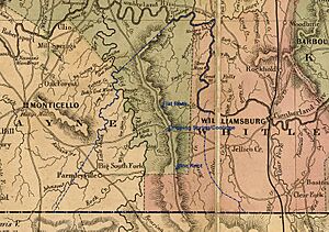
The land that is now McCreary County has a long history. It was once part of a much larger area called Fincastle County, Virginia, back in 1772. Over many years, this large area was divided into smaller counties. Finally, in 1912, the Kentucky Legislature created McCreary County. It was formed from parts of Pulaski, Wayne, and Whitley Counties. McCreary County was the 120th and last county to be formed in Kentucky. Its borders have stayed the same ever since.
An important old road in the area was the Jacksboro Road. This road was originally an old Native American trail. Other trails met this road, leading to the creation of small villages like Pine Knot. Early on, people in the area mostly farmed for their own food. They also worked in timber and small coal mines.
In the early 1800s, Cumberland Falls became a popular place for tourists. More people visited after roads were built. In 1930, the Falls became part of the state park system.
The arrival of the Cincinnati Southern Railway in 1880 changed the county's economy. It became easier to transport timber and coal to other places. This led to many small mining and logging companies starting up. The Justus S. Stearns companies had the biggest impact. They controlled much of the county's economy from 1903 onwards.
During the Great Depression in the 1930s, the Stearns companies sold a lot of their land to the U.S. Government. This land became part of the Daniel Boone National Forest in 1937. Later, in the 1970s, more land was added to create the Big South Fork National River and Recreation Area.
Geography of McCreary County
McCreary County covers about 431 square miles. Most of this is land, with a small amount of water.
Land Features
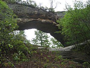
McCreary County is on the western edge of the Cumberland Plateau. This area is known for its coal fields. The Big South Fork of the Cumberland River has carved deep valleys and gorges. You can see amazing sheer cliffs, waterfalls, and natural stone arches. The ground here has thick sandstone and a lot of coal. Because there isn't much land for large farms, the economy has historically focused on getting resources like timber and coal from the land.
Neighboring Counties
- Pulaski County (north)
- Laurel County (northeast)
- Whitley County (east)
- Campbell County, Tennessee (southeast)
- Scott County, Tennessee (south)
- Wayne County (west)
Protected Natural Areas
- Big South Fork National River and Recreation Area (part)
- Daniel Boone National Forest (part)
Population of McCreary County
| Historical population | |||
|---|---|---|---|
| Census | Pop. | %± | |
| 1920 | 11,676 | — | |
| 1930 | 14,627 | 25.3% | |
| 1940 | 16,451 | 12.5% | |
| 1950 | 16,660 | 1.3% | |
| 1960 | 12,463 | −25.2% | |
| 1970 | 12,548 | 0.7% | |
| 1980 | 15,634 | 24.6% | |
| 1990 | 15,603 | −0.2% | |
| 2000 | 17,080 | 9.5% | |
| 2010 | 18,306 | 7.2% | |
| 2020 | 16,888 | −7.7% | |
| 2023 (est.) | 17,050 | −6.9% | |
| U.S. Decennial Census 1790–1960 1900–1990 1990–2000 2010–2020 |
|||
In 2000, there were 17,080 people living in McCreary County. The population density was about 40 people per square mile. The average age of people in the county was 34 years old.
Economy of McCreary County
McCreary County's economy has changed a lot over time. It used to rely heavily on coal mining and timber. However, the last coal mine in the county closed in 1994. It's unlikely that the coal industry will return because of environmental concerns.
Many people in McCreary County rely on government programs for support. These programs help families and individuals with their income and healthcare needs.
Since the 1970s, the county has tried to bring in new industries, like sewing companies. Some of these companies still operate, often making products for the military or high-end goods. Timber is still a part of the economy, with logging and wood production. The county is working to attract new businesses by building special industrial parks.
Farming has never been a big part of the county's economy. In 2002, only 5% of the county was used for farmland. The main farm products were livestock and hay. This is partly because over 80% of the county's land is owned by the federal government.
The tourism industry is growing in McCreary County. Places like Historic Stearns, the scenic railway, and the reconstructed coal mining camps of Blue Heron and Barthell attract visitors. These sites show what coal mining life was like in America. The Big South Fork Scenic Railway is even planning to add a steam locomotive and extend its line.
The Big South Fork National River and Recreation Area is a huge park, with about one-third of it in McCreary County. While the main visitor center is in Tennessee, the park offers many natural attractions. The Stearns area of the Daniel Boone National Forest also draws visitors who enjoy nature.
Transportation in McCreary County
McCreary County Airport is located near Pine Knot.
US 27 is a major highway that runs north and south through the county. KY 92 runs east and west. These two roads run together for a bit between Pine Knot and Stearns. The county also has train service from the Norfolk Southern Railway.
Communities in McCreary County
McCreary County does not have any official cities or townships. However, it has several communities that are recognized as census-designated places:
- Pine Knot
- Stearns
- Whitley City (the county seat)
Attractions in McCreary County
|
|
Notable People from McCreary County
- Wilburn K. Ross
- Allie Leggett
- Will Lavender
See also
 In Spanish: Condado de McCreary para niños
 | Audre Lorde |
 | John Berry Meachum |
 | Ferdinand Lee Barnett |


