
Wayne County, Kentucky facts for kids
Quick facts for kids
Wayne County
|
|
|---|---|

Wayne County courthouse in Monticello
|
|

Location within the U.S. state of Kentucky
|
|
 Kentucky's location within the U.S. |
|
| Country | |
| State | |
| Founded | December 13, 1800 |
| Named for | Anthony Wayne |
| Seat | Monticello |
| Largest city | Monticello |
| Area | |
| • Total | 484 sq mi (1,250 km2) |
| • Land | 458 sq mi (1,190 km2) |
| • Water | 26 sq mi (70 km2) 5.4% |
| Population
(2020)
|
|
| • Total | 19,555 |
| • Estimate
(2023)
|
19,580 |
| • Density | 40.40/sq mi (15.600/km2) |
| Time zone | UTC−5 (Eastern) |
| • Summer (DST) | UTC−4 (EDT) |
| Congressional district | 5th |
Wayne County is a county in the state of Kentucky. It is located along Kentucky's southern border with Tennessee.
In 2020, about 19,555 people lived there. The main town and county seat is Monticello. The county is named after General Anthony Wayne, a hero from the American Revolution. As of November 3, 2020, people in Wayne County voted to allow the sale of alcoholic drinks.
Contents
History of Wayne County
The first known European-American visitors to this area were longhunters in the 1770s. They set up a temporary camp near Mill Springs by the Cumberland River. Benjamin Price built a log cabin in 1775. His place, Price's Station, became one of Kentucky's first settlements. This land was originally home to the Cherokee people. As more Americans moved in, there were conflicts between the groups.
Many soldiers from the American Revolution came to Wayne County after the war. They included Joshua Jones (1794), Jonathan and James Ingram (1796), Cornelius Phillips (1798), and Isaac West (1799). The United States government gave them land here instead of paying them for their service in the war.
Wayne County was officially formed on December 13, 1800. It was created from parts of Pulaski and Cumberland counties. It was the 43rd county in Kentucky. The county is named after General "Mad Anthony" Wayne. He was a hero of the American Revolution and the Northwest Indian War. General Wayne's victory at the Battle of Fallen Timbers helped end threats from Native American groups against Kentucky settlers.
The area became important for farming. People who were forced to work on farms helped develop the land. During the American Civil War, Confederate Army General Felix Zollicoffer set up his headquarters at the Brown-Lanier House in Mill Springs. He was killed at the Battle of Mill Springs on January 19, 1862. He accidentally approached Union troops, thinking they were his own. Without their leader, the Confederate soldiers lost the battle.
In the winter of 1861, the Confederate Government of Kentucky tried to change the county's name to Zollicoffer County. This was to honor General Felix Zollicoffer after his death.
Geography of Wayne County
Wayne County covers about 484 square miles. About 458 square miles are land, and 26 square miles (5.4%) are water.
The land in the county ranges from about 656 feet to 1,870 feet above sea level. At the Monticello/Wayne County Airport, the elevation is about 963 feet. Wayne County is part of Kentucky's Pennyrile Plateau (image) and Eastern Coal Field (image) regions.
Neighboring Counties
- Russell County - northwest
- Pulaski County - northeast
- McCreary County - east
- Scott County, Tennessee - southeast
- Pickett County, Tennessee - south
- Clinton County - west
Protected Areas
- Daniel Boone National Forest (part of it is in Wayne County)
Time Zone Boundary

Wayne County is in the Eastern Time Zone. However, its western border touches Clinton and Russell Counties, which are in the Central Time Zone. The southern border with Pickett County, Tennessee, is also a time zone boundary. Wayne County used to be in the Central Time Zone until October 2000. A professor from the University of Kentucky, Dr. Stanley Brunn, wrote about this change.

Population Changes
| Historical population | |||
|---|---|---|---|
| Census | Pop. | %± | |
| 1810 | 5,430 | — | |
| 1820 | 7,951 | 46.4% | |
| 1830 | 8,685 | 9.2% | |
| 1840 | 7,399 | −14.8% | |
| 1850 | 8,692 | 17.5% | |
| 1860 | 10,259 | 18.0% | |
| 1870 | 10,602 | 3.3% | |
| 1880 | 12,512 | 18.0% | |
| 1890 | 12,852 | 2.7% | |
| 1900 | 14,892 | 15.9% | |
| 1910 | 17,518 | 17.6% | |
| 1920 | 16,208 | −7.5% | |
| 1930 | 15,848 | −2.2% | |
| 1940 | 17,204 | 8.6% | |
| 1950 | 16,475 | −4.2% | |
| 1960 | 14,700 | −10.8% | |
| 1970 | 14,268 | −2.9% | |
| 1980 | 17,022 | 19.3% | |
| 1990 | 17,468 | 2.6% | |
| 2000 | 19,923 | 14.1% | |
| 2010 | 20,813 | 4.5% | |
| 2020 | 19,555 | −6.0% | |
| 2023 (est.) | 19,580 | −5.9% | |
| US Decennial Census 1790-1960 1900-1990 1990-2000 2010-2020 |
|||
In 2000, there were 19,923 people living in Wayne County. The population density was about 43 people per square mile. Most people in the county were White (96.98%). About 25.30% of the population was under 18 years old. The average age was 37 years.
Famous People from Wayne County
- Dick Burnett – A musician who wrote the famous song "Man of Constant Sorrow" in the early 1900s. He was born near Monticello in 1883.
- Emry Arthur – An early folk and country musician. He was active in the 1920s and 1930s and recorded a popular version of Burnett's song. He was born in 1902 in Elk Spring Valley.
- Polly Berry – An enslaved woman who won her freedom and her daughter's freedom in court. She lived in Wayne County as a child.
- Lettice Bryan – The author of a popular cookbook called The Kentucky Housewife (1839). She lived in Wayne County when her cookbook was published.
- Shelby M. Cullom (1829–1914) – He was the Governor of Illinois (1877–1883) and a U.S. Senator (1883–1913).
- Preston H. Leslie (1819–1907) – He served as Governor of Kentucky (1871–1875) and Governor of Montana (1887–1889).
- Harriette Simpson Arnow (1908–1986) – An American novelist and historian. She was born in Monticello, Wayne County.
- Hal Rogers – A U.S. Congressman who has served since 1981.
- Kenny Davis – An American Olympic basketball player in 1972.
- John S. Van Winkle – A former Secretary of State of Kentucky.
- Ephraim L. Van Winkle – Also a former Secretary of State of Kentucky.
Historical Places to Visit
- William Crenshaw Kennedy, Jr. Memorial Museum and Genealogy Library
- Doughboy Monument – Located in Monticello town square, it honors soldiers from World War I.
- Mill Springs Mill (1877) and Park – A water-powered mill that still works today.
- Brown-Lanier House – A historic home connected to the Civil War Battle of Mill Springs.
- Raccoon John Smith Cabin – The early home of a religious leader and founder of the Restoration Movement.
Communities in Wayne County
City
- Monticello (This is the county seat)
Small Towns and Areas
- Barrier
- Big Sinking
- Cooper
- Duncan Valley
- Fall Creek
- Frazer
- Frisby
- Hidalgo
- Mill Springs
- Parmleysville
- Powersburg
- Rockybranch
- Roger's Grove
- Steubenville
- Sunnybrook
- Windy
Education
Wayne County Schools runs the public schools in the county.
On June 30, 2013, Monticello Independent Schools joined with Wayne County Schools.
Students can also get vocational education at the Wayne County Area Technology Center (ATC). This school helps high school students learn job skills. It offers programs in Health Science, Welding, Carpentry, Machine Tool, Automotive, Industrial Maintenance, and Business.
Images for kids
-
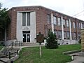
Wayne County courthouse in Monticello
-
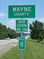
Along KY 90
-
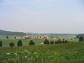
Farmland in Wayne County
See also
 In Spanish: Condado de Wayne (Kentucky) para niños
