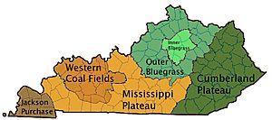
Pennyroyal Plateau facts for kids
The Pennyroyal Plateau is a large area in Kentucky that has rolling hills, many caves, and special landforms called karst topography. Karst is a type of landscape where the bedrock, usually limestone, has been dissolved by water. This creates features like sinkholes, underground rivers, and caves.
The Pennyroyal Plateau gets its name from a type of wild mint plant that grows there. It's also known as the "Mississippian Plateau." This name comes from the Mississippian geologic age, which is a time period millions of years ago when the rocks forming the plateau were created.
Contents
Where is the Pennyroyal Plateau?
The Pennyroyal Plateau is surrounded by different regions of Kentucky.
Eastern Border: Pottsville Escarpment
To the east, the Pennyroyal Plateau meets the Pottsville Escarpment. An escarpment is like a steep slope or cliff that separates two different land areas. This escarpment is where the land changes from the central part of Kentucky to the higher Cumberland Plateau in the eastern part of the state. The Cumberland Plateau has rocks that are geologically younger, meaning they formed more recently.
Northern Border: Muldraugh Hill
To the north, the Pennyroyal Plateau is next to Muldraugh Hill. This is another geological escarpment. It marks the change from the older Bluegrass area to the Pennyroyal. Muldraugh Hill is made up of a series of small hills and ridges. These are formed from hard rocks called siltstones.
Western Border: Jackson Purchase
To the west, the Pennyroyal Plateau borders the Jackson Purchase. This area is geologically younger than the Pennyroyal. Sometimes, people who aren't geologists might think the Pennyroyal includes the West Kentucky Coal Field. This coal field is in the northwestern part of Kentucky and is part of a larger area called the Illinois Basin. However, the coal field and the Pennyroyal are actually from different geologic ages. They are separated by a region called the Clifty Region, which is mostly made of Pennsylvanian sandstone. The exact boundary between the Pennyroyal and the Clifty Region is the Dripping Springs Escarpment.
Southern Border: Highland Rim
To the south, the Pennyroyal Plateau continues into Middle Tennessee. There, it is known as the Highland Rim.
Geology and Caves
Most of the Pennyroyal Plateau is farmland. The ground beneath this farmland is mostly limestone. This limestone was formed during the Mississippian geologic age. Important types of limestone found here include the St. Louis Limestone and Ste. Genevieve Limestone.
In some places, the limestone is covered by a layer of soft sandstone. This combination of limestone and sandstone is perfect for forming caves. It's especially true in the Mammoth Cave area. This unique geology has allowed the formation of the world's largest cave system!
Many other caves can be found throughout the Pennyroyal Plateau. Some of the best cave-forming limestones in the world are located here. Where the sandstone layer is still on top, the land is usually covered with forests and has rugged hills.
 | May Edward Chinn |
 | Rebecca Cole |
 | Alexa Canady |
 | Dorothy Lavinia Brown |


