Cumberland County, Kentucky facts for kids
Quick facts for kids
Cumberland County
|
|
|---|---|

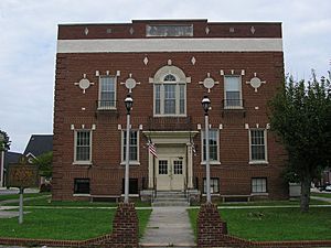
Cumberland County courthouse in Burkesville
|
|

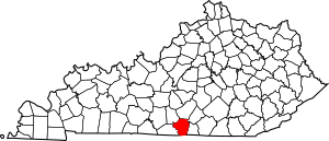
Location within the U.S. state of Kentucky
|
|
 Kentucky's location within the U.S. |
|
| Country | |
| State | |
| Founded | 1798 |
| Named for | Cumberland River |
| Seat | Burkesville |
| Largest city | Burkesville |
| Area | |
| • Total | 311 sq mi (810 km2) |
| • Land | 305 sq mi (790 km2) |
| • Water | 5.7 sq mi (15 km2) 1.8%% |
| Population
(2020)
|
|
| • Total | 5,888 |
| • Estimate
(2023)
|
6,000 |
| • Density | 18.93/sq mi (7.310/km2) |
| Time zone | UTC−6 (Central) |
| • Summer (DST) | UTC−5 (CDT) |
| Congressional district | 1st |
Cumberland County is a county in the U.S. state of Kentucky. It's part of the Pennyroyal Plateau region. In 2020, about 5,888 people lived there. The main town and county seat is Burkesville.
The county was started in 1798. It was named after the Cumberland River. The river itself might have been named after the Duke of Cumberland or a place in England called Cumberland.
Contents
History of Cumberland County
Cumberland County was created in 1798 from land that used to be part of Green County.
First Oil Well
In 1829, something interesting happened near Burkesville. The first commercial oil well in the United States was dug there! People were actually looking for salt water, but they found oil instead. They even bottled and sold the oil.
First Female Sheriff
Cumberland County was also the first county in the entire United States to elect a female sheriff. Her name was Pearl Carter Pace.
Wolf Creek Dam
The town of Burkesville is located just downstream from Wolf Creek Dam. This means the town is usually safe from floods. However, there were some worries about leaks at the dam in the past. The U.S. Army Corps of Engineers finished fixing the dam in 2013, making it safe again.
Geography of Cumberland County
Cumberland County covers about 311 square miles. Most of this area, about 305 square miles, is land. The rest, about 5.7 square miles, is water.
Waterways
The main river flowing through the county is the Cumberland River. There's also a small part of Dale Hollow Lake in the southern end of the county.
Neighboring Counties
Cumberland County shares borders with these other counties:
- Adair County (to the north)
- Russell County (to the northeast)
- Clinton County (to the east)
- Clay County, Tennessee (to the south)
- Monroe County (to the west)
- Metcalfe County (to the northwest)
Population of Cumberland County
| Historical population | |||
|---|---|---|---|
| Census | Pop. | %± | |
| 1800 | 3,284 | — | |
| 1810 | 6,191 | 88.5% | |
| 1820 | 8,058 | 30.2% | |
| 1830 | 8,624 | 7.0% | |
| 1840 | 6,090 | −29.4% | |
| 1850 | 7,005 | 15.0% | |
| 1860 | 7,340 | 4.8% | |
| 1870 | 7,690 | 4.8% | |
| 1880 | 8,894 | 15.7% | |
| 1890 | 8,452 | −5.0% | |
| 1900 | 8,962 | 6.0% | |
| 1910 | 9,846 | 9.9% | |
| 1920 | 10,648 | 8.1% | |
| 1930 | 10,204 | −4.2% | |
| 1940 | 11,923 | 16.8% | |
| 1950 | 9,309 | −21.9% | |
| 1960 | 7,835 | −15.8% | |
| 1970 | 6,850 | −12.6% | |
| 1980 | 7,289 | 6.4% | |
| 1990 | 6,784 | −6.9% | |
| 2000 | 7,147 | 5.4% | |
| 2010 | 6,856 | −4.1% | |
| 2020 | 5,888 | −14.1% | |
| 2023 (est.) | 6,000 | −12.5% | |
| U.S. Decennial Census 1790-1960 1900-1990 1990-2000 2010-2021 |
|||
The population of Cumberland County has changed over the years. In 2000, there were 7,147 people living there. By 2020, the population was 5,888.
Communities in Cumberland County
Cumberland County has one main city and several smaller communities.
City
- Burkesville (This is the county seat, where the main government offices are.)
Census-Designated Place
Other Small Towns
- Amandaville
- Bakerton
- Bow
- Dubre
- Green Grove
- Grider
- Judio
- Kettle
- Modoc
- Peytonsburg
- Waterview
Notable People from Cumberland County
Many interesting people have come from Cumberland County:
- William M. Branham: A Christian minister known for his healing services after World War II.
- Joel Owsley Cheek: He was the person who started the famous coffee company, Maxwell House.
- Edwin L. Norris: He served as the fifth Governor of Montana.
- David L. Williams: He is a judge and used to be the President of the Kentucky Senate. He also ran for the U.S. Senate and for Governor of Kentucky.
See also
 In Spanish: Condado de Cumberland (Kentucky) para niños
 | Sharif Bey |
 | Hale Woodruff |
 | Richmond Barthé |
 | Purvis Young |

