Marrowbone, Cumberland County, Kentucky facts for kids
Quick facts for kids
Marrowbone, Kentucky
|
|
|---|---|

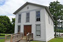
Modern Woodmen lodge building on Kentucky Route 90
|
|
| Country | United States |
| State | Kentucky |
| County | Cumberland |
| Area | |
| • Total | 1.29 sq mi (3.34 km2) |
| • Land | 1.27 sq mi (3.30 km2) |
| • Water | 0.01 sq mi (0.04 km2) |
| Elevation | 643 ft (196 m) |
| Population
(2020)
|
|
| • Total | 147 |
| • Density | 115.38/sq mi (44.54/km2) |
| Time zone | UTC-6 (Central (CST)) |
| • Summer (DST) | UTC-5 (CDT) |
| ZIP codes |
42759
|
| FIPS code | 21-50124 |
| GNIS feature ID | 497558 |
Marrowbone is a small community located in Cumberland County, Kentucky, in the United States. It is called a "census-designated place" because the U.S. Census Bureau defines its borders for counting people.
As of the 2020 census, about 147 people lived in Marrowbone. The community has its own post office and a ZIP code of 42759.
Marrowbone is also home to the Marrowbone Historic District. This district includes three special buildings or places. They are listed on the National Register of Historic Places, which means they are important for their history.
Geography and Location
Marrowbone is found in the western part of Cumberland County. It is located along Kentucky Route 90. This road runs west of Burkesville, which is the main town and county seat of Cumberland County.
The land in Marrowbone is about 643 feet above sea level. Its exact location is around 36.8288889 degrees north and 85.5030556 degrees west.
Population and People
The population of Marrowbone has changed over the years. Here is how many people lived there during recent U.S. Census counts:
| Historical population | |||
|---|---|---|---|
| Census | Pop. | %± | |
| 2020 | 147 | — | |
| U.S. Decennial Census | |||
In 2020, the population was 147 people. This information helps us understand how the community has grown or changed.
See also
 In Spanish: Marrowbone (Kentucky) para niños
 | Charles R. Drew |
 | Benjamin Banneker |
 | Jane C. Wright |
 | Roger Arliner Young |


