
Burkesville, Kentucky facts for kids
Quick facts for kids
Burkesville, Kentucky
|
|
|---|---|

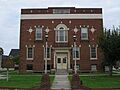
Cumberland County courthouse in Burkesville
|
|

Location of Burkesville in Cumberland County, Kentucky.
|
|
| Country | United States |
| State | Kentucky |
| County | Cumberland |
| Area | |
| • Total | 2.65 sq mi (6.87 km2) |
| • Land | 2.57 sq mi (6.67 km2) |
| • Water | 0.08 sq mi (0.20 km2) |
| Elevation | 581 ft (177 m) |
| Population
(2020)
|
|
| • Total | 1,388 |
| • Estimate
(2022)
|
1,380 |
| • Density | 539.24/sq mi (208.19/km2) |
| Time zone | UTC-5 (CST) |
| • Summer (DST) | UTC-4 (CDT) |
| ZIP code |
42717
|
| Area code(s) | 270 & 364 |
| FIPS code | 21-11098 |
| GNIS feature ID | 0488433 |
Burkesville is a small city in Cumberland County, Kentucky, in the United States. It is located among the rolling hills of Appalachia. The Cumberland River borders it to the south and east. Burkesville is the main town, or seat, of its county. In 2020, about 1,388 people lived there.
Contents
History of Burkesville
Burkesville started as a small settlement near the river. This was even before Native American tribes officially sold the land in 1768. The first name for the settlement was Cumberland Crossing. In 1846, it became an official city. It was named Burkesville after Isham Burk, who was an important local leader at that time.
Burkesville During the Civil War
During the Civil War, Kentucky was a "border state." This meant it was between the Union (North) and the Confederacy (South). Burkesville was also a border town. The Cumberland River was a natural barrier between the two sides. Both Union and Confederate soldiers fought in the area. Local fighters also caused trouble.
Confederate General John Hunt Morgan led his troops through the area. Confederate General Hylan B. Lyon also led raids in December 1864. His raids burned seven courthouses, including the one in Burkesville on January 3.
River Trade and Changes
Burkesville was once a very busy river port. This was especially true in the late 1800s. Back then, moving goods by water was the best way to transport large amounts. Big boats like steamboats needed the river to be deep enough. So, the riverbed had to be cleaned often.
The last steamboat came to Burkesville in 1929. This was a year after the first major road opened to Glasgow, a larger city about 40 miles (64 km) west. Later, the U.S. Army Corps of Engineers built Wolf Creek Dam. This dam helped stop floods that had always bothered the town. However, it also meant that large boats could no longer travel up the river to Burkesville.
Modern Burkesville
In 1944, the Corps of Engineers created Dale Hollow Reservoir. This lake brought tourists and fishing to Burkesville. Fishing for trout in the river below the dam also helps the local economy. Dale Hollow Lake State Resort Park has also been developed nearby.
In the late 1930s and early 1940s, Burkesville had a special library. It was called the pack horse library. Librarians rode horses to deliver books to people living in rural areas.
Today, you can reach Burkesville by State Highways 90 and 61. The town has an old-fashioned town square on Main Street. This street goes around the Cumberland County court house. The current courthouse is the third one built there. The first one was built by Thomas Lincoln, who was the father of Abraham Lincoln.
Geography
Burkesville is located at 36°47′34″N 85°22′10″W / 36.79278°N 85.36944°W.
The city covers about 2.65 square miles (6.85 square kilometers). Most of this area is land, and a small part is water.
Climate
The weather in Burkesville has hot, humid summers. Winters are usually mild to cool. This type of weather is called a humid subtropical climate. On climate maps, it's often shown as "Cfa."
Population Information
| Historical population | |||
|---|---|---|---|
| Census | Pop. | %± | |
| 1810 | 106 | — | |
| 1840 | 340 | — | |
| 1850 | 369 | 8.5% | |
| 1880 | 434 | — | |
| 1910 | 817 | — | |
| 1920 | 798 | −2.3% | |
| 1930 | 886 | 11.0% | |
| 1940 | 1,092 | 23.3% | |
| 1950 | 1,278 | 17.0% | |
| 1960 | 1,688 | 32.1% | |
| 1970 | 1,717 | 1.7% | |
| 1980 | 2,051 | 19.5% | |
| 1990 | 1,815 | −11.5% | |
| 2000 | 1,756 | −3.3% | |
| 2010 | 1,521 | −13.4% | |
| 2020 | 1,388 | −8.7% | |
| 2022 (est.) | 1,380 | −9.3% | |
| U.S. Decennial Census | |||
In 2000, there were 1,756 people living in Burkesville. There were 768 households, which are groups of people living together. About 27% of these households had children under 18.
The population was spread out by age. About 23% of the people were under 18. About 23% were 65 years old or older. The average age was 42 years.
Education
Burkesville has a public library where you can borrow books. It is called the Cumberland County Public Library.
Notable People from Burkesville
- Two governors of Kentucky were born in the area that became Clinton County, near Burkesville. Their names were Thomas E. Bramlette and Preston H. Leslie.
- Thomas Lincoln, who was the father of the 16th President Abraham Lincoln, lived in Cumberland County. He served as a local officer called a constable from 1802 to 1804.
- David L. Williams is a judge in Kentucky. He used to be the president of the state Senate.
- William Marrion Branham was born in Burkesville. He became a well-known Christian minister, especially in the Pentecostal faith.
Images for kids
-
Cumberland County courthouse in Burkesville
-

Location of Burkesville in Cumberland County, Kentucky.
See also
 In Spanish: Burkesville (Kentucky) para niños
