
Cumberland facts for kids
| Cumberland | |
 Flag |
|
| Cumberland en 1851.svg | |
| Geography | |
| Status |
|
| 1831 area | 969,490 acres (3,923.4 km2)1831 Census cited in Vision of Britain – Ancient county data |
| 1911 area | 973,086 acres (3,937.94 km2) |
| 1961 area | 973,146 acres (3,938.18 km2) |
| HQ | Carlisle |
| Chapman code | CUL |
| History | |
| Origin | Historic |
| Created | 12th Century |
Quick facts for kids Demography |
|
|---|---|
| 1911 population - 1911 density |
265,746 Vision of Britain – Cumberland population (density and area) 0.27/acre (0.67/ha) |
| 1961 population - 1961 density |
294,303 0.3/acre (0.74/ha) |
| Politics | |
| Governance | Cumberland County Council (1889–1974) |
 Arms of Cumberland County Council |
|
| Subdivisions | |
| Type | Wards |
 |
|
| Units |
|
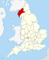
Cumberland (/ˈkʌmbərlənd/ KUM-bər-lənd) is a historic area in Northern England. It was once a county, which is a traditional region with its own government. It shares borders with other historic counties like Northumberland and County Durham to the east. To the south, it borders Westmorland and Lancashire. To the north, it borders the Scottish counties of Dumfriesshire and Roxburghshire.
This area includes the city of Carlisle, parts of the beautiful Lake District and North Pennines mountains, and the Solway Firth coastline. Cumberland had its own local government from the 1100s until 1974. At that time, it became part of a larger area called Cumbria, along with Westmorland and parts of Yorkshire and Lancashire. Today, a new local government area called Cumberland has similar borders, but it does not include the town of Penrith.
Contents
History of Cumberland
Early Times and Name Origin
Long ago, in the Early Middle Ages, the area known as Cumbria was part of a kingdom called Strathclyde. The people living there spoke an old language called Cumbric. The name 'Cumberland' first appeared in the year 945. The Anglo-Saxon Chronicle (a historical record) says that King Edmund I of England gave this land to Malcolm I, who was the king of Scotland.
The names 'Cumberland' and 'Cumbria' come from an old word, kombroges. This word meant "compatriots" or "people from the same country." It's similar to how the Welsh people call their country 'Cymru'.
Becoming Part of England
Around the year 1086, when the Domesday Book was created (a famous survey of England), most of the future Cumberland area was still part of Scotland. However, some villages near Millom were owned by an English earl and were part of Yorkshire.
In 1092, King William Rufus of England took over the Carlisle area. He brought new settlers and created an Earldom of Carlisle. An earldom was a territory ruled by an earl. In 1133, Carlisle became the center of a new church area called a diocese.
However, after King Henry I of England died in 1135, the Scottish King David I of Scotland took the area back. He made Carlisle an important center for his government. During this time, the Cumbric language likely died out around the 1100s.

In 1157, the area returned to England when Henry II of England took it from Malcolm IV of Scotland. King Henry II then created two new counties: Westmorland and Carliol. Carliol was a shorter name for 'Carlisle'. By 1177, Carliol was known as Cumberland. The border between England and Scotland was officially set in 1237 by the Treaty of York.
Geography of Cumberland
The borders of Cumberland, set in the 1100s, stayed mostly the same for a long time. It borders four English historic counties: Northumberland, County Durham, Westmorland, and Lancashire. It also borders two Scottish counties: Dumfriesshire and Roxburghshire.
To the west, Cumberland meets the Solway Firth and the Irish Sea. The northern border follows the Solway Estuary and the Scottish border. The eastern border runs along the Cheviot Hills and then follows rivers like the Irthing and Tees. From the Tees, it crosses the Pennines mountains. The southern border follows rivers like the Eden, Eamont, and Duddon.
The highest point in Cumberland is Scafell Pike. It stands at 3,208 feet (978 m) high, making it the tallest mountain in England. The main town of the county is Carlisle.
Divisions of the County

When Cumberland was created, it was divided into areas called wards. Wards were like smaller sections of the county. They were first used to organize men for defense against Scottish attacks.
Each ward was made up of several parishes. Parishes were originally church areas. In northern England, many old parishes were very large. They often included many smaller villages and hamlets. Over time, many of these became civil parishes, which are the smallest units of local government.
The five main wards of Cumberland were:
- Allerdale Above Derwent
- Allerdale Below Derwent
- Eskdale
- Leath
- Cumberland Ward
Cumberland's Legacy Today
Even though Cumberland is no longer an administrative county, its name is still used in many ways. It's a geographical and cultural term. You can find its name in:
- Cumberland sausages, a famous local food.
- HMS Cumberland, a ship.
- Sports clubs like the Cumberland Fell Runners Club and the Cumberland Athletics Club.
- Local newspapers such as The Cumberland News.
- The Cumberland Building Society, a financial company.
The county is also mentioned in famous works like Shakespeare's play Macbeth. It is also the starting place for the historical novel Cue for Treason by Geoffrey Trease.
In 2012, a special flag was created for Cumberland. It is based on the old coat of arms of the Cumberland County Council. This flag is now officially recognized.
In 2013, a government official, Eric Pickles, officially said that England's 39 historic counties, including Cumberland, still exist. This means they are recognized for their history and culture.
In 2021, it was announced that local government in Cumbria would change again in 2023. Two new unitary authorities (single-tier local governments) were created. One of these is also called Cumberland. This new authority covers most of the historic county, except for the area around Penrith. It includes about 77% of the historic county's land and 90% of its people.
The Grass-of-Parnassus flower is the official county flower of Cumberland. It has been linked to the county since 1951. It was even included in the coat of arms for the Cumberland County Council.
Images for kids
-
Map of Cumberland in 1851
-
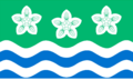
Flag of Cumberland
-
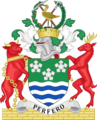
Arms of Cumberland County Council
-
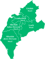
Wards of Cumberland

See also
 In Spanish: Cumberland para niños
