
Westmorland facts for kids
| Westmorland | |
 Flag |
|
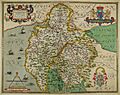
 Ancient extent of Westmorland |
|
| Geography | |
| Status | Historic county (current) Ceremonial county (until 1974) Administrative county (1889–1974) |
| 1831 area | 485,990 acres (1,966.7 km2) |
| 1911 area | 505,330 acres (2,045.0 km2) |
| 1961 area | 504,917 acres (2,043.33 km2) |
| HQ | Appleby (historic county town) County Hall, Kendal (1889-1974) |
| Chapman code | WES |
| History | |
| Origin | Barony of Kendal, Barony of Westmorland |
| Created | 13th century |
| Succeeded by | Cumbria |
Quick facts for kids Demography |
|
|---|---|
| 1911 population | 63,575 |
| 1961 population | 67,180 |
| Politics | |
| Governance | Westmorland County Council (1889-1974) |
 Arms of Westmorland County Council |
|
| Subdivisions | |
| Type | Baronies and Wards |
 |
|
| Units | Westmorland: •East •West Kendal: •Kendal •Lonsdale |
Westmorland is an area in Northern England. It was once a historic county. People from this area are called Westmerians. The region includes parts of the famous Lake District and the southern Vale of Eden.
Westmorland was an official county from the 12th century until 1974. In 1974, it joined with other areas to form Cumbria. These areas included Cumberland, parts of Yorkshire, and parts of Lancashire. Today, the name Westmorland is used for the Westmorland and Furness area of Cumbria. This new area is even larger than the old county.
Contents
Westmorland's Early History
How Westmorland Began
In the early 900s, a large part of what is now Cumbria was called "Scottish Cumberland." It was part of the Kingdom of Strathclyde.
The Rere Cross was a special stone marker. King Edmund I (who ruled from 939 to 946) ordered it to be set up. It marked the border between England and "Scottish Cumberland."
Forming the County
In 1086, when the Domesday Book was made, Westmorland did not exist as a county. Half of the area was part of Yorkshire. The other half was part of Scotland.
Before 1226, the Barony of Kendal was linked to Honour of Lancaster. The Barony of Westmorland was part of the Earldom of Carlisle. This area sometimes belonged to Scotland.
Both baronies became the single county of Westmorland in 1226 or 1227. The nearby county of Lancashire was also formed around this time. Appleby became the historic county town. It was given its special town status in 1179.
Westmorland's Geography

Westmorland shared borders with several other counties. To the north was Cumberland. To the east were County Durham and Yorkshire. To the south and west was Lancashire.
Windermere lake formed part of the western border. Ullswater lake was part of the border with Cumberland. The highest point in the county is Helvellyn, which is 3,117 feet (950 meters) tall. In 1831, the county covered an area of 485,990 acres (196,670 hectares).
How Westmorland Was Divided
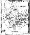
Westmorland was split into two main areas called baronies. These were the Barony of Westmorland (also called Appleby) and the Barony of Kendal. Like some other northern counties, Westmorland was also divided into smaller areas called wards. Each barony had two wards:
- Westmorland Barony
- East ward – This area included towns like Appleby, Brough, Kirkby Stephen, Orton, and Tebay.
- West ward – This area included places like Askham, Bampton, Barton, Patterdale, Shap, and Yanwath.
- Kendal Barony
- Kendal ward – This area included Ambleside, Burton-in-Kendal, Grasmere, Grayrigg, Kentmere, Kendal, and Windermere.
- Lonsdale ward – This area included Kirkby Lonsdale.
Westmorland's Modern History
In 1889, a new county council was created. This council took over many local government jobs. The council's main office was at County Hall in Kendal. However, important legal meetings were held in Shire Hall in Appleby.
Kendal became a special town (municipal borough) in 1835, and Appleby in 1885. Westmorland never had any "county boroughs." This meant the area controlled by the county council was the same as the geographic county.
Besides Kendal and Appleby, the county was divided into smaller areas in 1894:
- Five urban districts: Ambleside, Bowness on Windermere, Grasmere, Kirkby Lonsdale, Windermere
- Three rural districts: West Ward, East Westmorland, South Westmorland
In 1905, a new Shap urban district was formed. Also, Windermere joined with Bowness.
In 1935, the number of districts in the county was reduced:
- A new Lakes Urban District was formed. It combined Ambleside and Grasmere.
- East Westmorland, most of West Ward, and Shap joined to form North Westmorland Rural District.
- South Westmorland Rural District took in Kirkby Lonsdale.
Even though they were called "urban districts," many of Westmorland's areas, like Lakes, Grasmere, and Shap, were quite rural.
In 1971, Westmorland was the second least populated county in England. Here's how many people lived in its different areas:
| District | Population |
|---|---|
| Municipal Borough of Appleby | 1,944 |
| Municipal Borough of Kendal | 21,602 |
| Lakes Urban District | 5,815 |
| Windermere Urban District | 8,065 |
| North Westmorland Rural District | 14,778 |
| South Westmorland Rural District | 20,633 |
In 1974, the county council was closed down. Westmorland's area joined with Cumberland and parts of Lancashire and Yorkshire. Together, they formed the new county of Cumbria. From 1974 to 2023, the area was part of the South Lakeland and Eden districts.
In July 2021, a plan was announced to change local government again. In April 2023, Cumbria County Council was replaced by two new authorities. One of these is called Westmorland and Furness. This new authority brings back much of historic Westmorland into one area. It also includes parts of Furness (from Lancashire), Penrith (from Cumberland), and Sedbergh (from Yorkshire).
What Does "Westmorland" Mean?
The name "Westmorland" has an interesting history. It comes from an old Anglo-Saxon name, "Westmoringaland." This meant 'the land of the people of the western moors.' These were the moors on the west side of the Pennine mountains.
However, the current name actually comes from "Westmarieland" or "Westmerieland," used in the 12th century. This means 'land of the western meres.' A "mere" can mean a boundary or a lake. It's not totally clear if the name refers to the lakes or the boundaries of the area.
Westmorland's Coat of Arms
The College of Arms gave Westmorland County Council its own coat of arms in 1926. The shield on the arms showed two red bars. These came from the de Lancaster family, who were important leaders in Kendal. On top of these bars was a gold apple tree. This came from the seal of Appleby town, representing the Barony of Westmorland.
Above the shield was the head of a local Herdwick ram. On the ram's forehead was a "shearman's hook." This tool was used for handling wool. The hook was part of the symbols for Kendal town, where the county council was based.
Westmorland's Legacy Today

In April 2023, Westmorland reappeared on maps as part of the new Westmorland and Furness authority. Even before this, between 1974 and 2023, the name Westmorland was still used by many groups and businesses in the area, showing its lasting identity:
- The Westmorland Gazette – a newspaper started in 1818.
- The Westmorland County Agricultural Society – founded in 1799, it holds an annual show.
- The Westmorland County Football Association – manages many local football leagues.
- The Westmorland Geological Society – formed in 1973.
- The Cumberland and Westmorland Antiquarian and Archaeological Society – founded in 1866.
- The Westmorland Youth Orchestra.
- The Westmorland Shopping Centre in Kendal.
- The Westmorland Cricket League.
- Westmorland Motorway Services – a company that runs service stations like Tebay services.
- In 1974, the local council for Appleby changed its name to Appleby-in-Westmorland.
- Westmorland General Hospital in Kendal.
- Westmorland croquet club.
The southern part of the county, known as the Barony of Kendal, is part of the Westmorland and Lonsdale parliamentary area.
In September 2011, the Westmorland Association, a local group, successfully registered the Flag of Westmorland with the Flag Institute.
In 2013, a government minister, Eric Pickles, officially recognized that England's 39 historic counties, including Westmorland, still exist.
In April 2023, local government in Cumbria was changed. It was split into two new areas. One of these is named Westmorland and Furness. This new area covers all of the historic Westmorland county, plus parts of historic Yorkshire, Lancashire, and Cumberland.
Notable People from Westmorland
- Sir Thomas Strickland – He carried the Flag of St. George in the famous battle of Agincourt.
- St. John Boste – A Roman Catholic priest and martyr.
- Mary Wakefield – A supporter of music, honored with an annual festival.
- Nicholas Freeston (1907–1978) – An award-winning poet, born in Kendal.
- George Romney – A portrait painter, many of his works are in Kendal Town Hall.
- William Parr, 1st Baron Parr of Kendal – He was the grandfather of Queen Catherine Parr, who was Henry VIII's sixth wife. The Parr family's old castle, Kendal Castle, is in Kendal.
- Tom Barker – A trade unionist and socialist, born in Crosthwaite.
- Margaret Cropper – A poet.
- Mary Rolls – A poet.
Images for kids
-
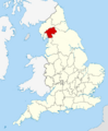
Ancient extent of Westmorland
-
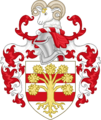
Arms of Westmorland County Council
-
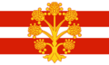
Flag of Westmorland
-
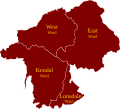
Wards of Westmorland
-
Hand-drawn map of Westmorland and Cumberland by Christopher Saxton from 1576
-
Map of Westmorland, 1824
