
Lancashire facts for kids
Quick facts for kids
Lancashire
|
|||||||||||||||||||||||||||||||||||||||||||||||||||||||||
|---|---|---|---|---|---|---|---|---|---|---|---|---|---|---|---|---|---|---|---|---|---|---|---|---|---|---|---|---|---|---|---|---|---|---|---|---|---|---|---|---|---|---|---|---|---|---|---|---|---|---|---|---|---|---|---|---|---|
|
Central Pier and the Tower, Blackpool; the Ashton Memorial, Lancaster; and a view of Clitheroe with the Forest of Bowland beyond
|
|||||||||||||||||||||||||||||||||||||||||||||||||||||||||
 |
|||||||||||||||||||||||||||||||||||||||||||||||||||||||||
| Sovereign state | United Kingdom | ||||||||||||||||||||||||||||||||||||||||||||||||||||||||
| Constituent country | England | ||||||||||||||||||||||||||||||||||||||||||||||||||||||||
| Region | North West England | ||||||||||||||||||||||||||||||||||||||||||||||||||||||||
| Established | c. 1182 | ||||||||||||||||||||||||||||||||||||||||||||||||||||||||
| Origin | Honour of Lancaster | ||||||||||||||||||||||||||||||||||||||||||||||||||||||||
| Time zone | UTC±00:00 (Greenwich Mean Time) | ||||||||||||||||||||||||||||||||||||||||||||||||||||||||
| • Summer (DST) | UTC+01:00 (British Summer Time) | ||||||||||||||||||||||||||||||||||||||||||||||||||||||||
| Members of Parliament | 16 MPs | ||||||||||||||||||||||||||||||||||||||||||||||||||||||||
| Police | Lancashire Constabulary | ||||||||||||||||||||||||||||||||||||||||||||||||||||||||
| Largest town | Blackpool | ||||||||||||||||||||||||||||||||||||||||||||||||||||||||
|
|||||||||||||||||||||||||||||||||||||||||||||||||||||||||
_(cropped).jpg)
.jpg)


Lancashire ( lan-KƏ-shər --sheer; abbreviated Lancs) is a ceremonial county in North West England. It is surrounded by Cumbria to the north, North Yorkshire and West Yorkshire to the east, Greater Manchester and Merseyside to the south, and the Irish Sea to the west. The largest town in Lancashire is Blackpool. Preston is the main administrative centre.
The county covers an area of about 3,079 square kilometres (1,189 sq mi) and has a population of around 1,490,300 people. After Blackpool, the biggest towns are Blackburn and Preston. The city of Lancaster has a population of about 52,655. For local government, Lancashire has twelve districts and two special areas called unitary authorities: Blackburn with Darwen and Blackpool. Historically, Lancashire was much larger, including parts of what are now Greater Manchester, Merseyside, Cumbria, and Cheshire.
Western Lancashire has flat coastal plains that rise to the Pennines hills in the east. The county is home to large parts of two beautiful National Landscapes: Arnside and Silverdale and the Forest of Bowland. It also has protected areas like the Ribble and Alt Estuaries National Nature Reserve. Major rivers like the Lune, Wyre, and Ribble flow west into the Irish Sea. The highest point in Lancashire is Gragareth or Green Hill, both about 628 metres (2,057 ft) high.
Lancashire was officially formed in 1182. Before that, much of the area was considered part of Yorkshire and Cheshire. For a long time, it was a quiet, less wealthy area. However, it became a "palatine" in 1351, meaning it had its own special legal system. This changed a lot during the Industrial Revolution, when the county quickly became a hub for factories. Until 1974, it included major cities like Liverpool (a big port) and Manchester (known for making textiles). Coal mining was also very important. By 1971, Lancashire was the second most populated county in the UK, after London.
Contents
History of Lancashire
How Lancashire Began
Before Lancashire became a county, during Roman times, this area was home to the Brigantes tribe. Roman forts were built here, leading to towns like Manchester, Lancaster, and Ribchester. After the Romans left around 410 AD, the northern parts of the county might have been part of a Celtic kingdom called Rheged. Later, in the 8th century, the area was split between the Anglo-Saxon kingdoms of Northumbria (north of the River Ribble) and Mercia (south). Both became part of England in the 10th century.
In the Domesday Book of 1086, the land between the Ribble and Mersey rivers was listed as "Inter Ripam et Mersam" and included with Cheshire. Some historians think this means south Lancashire was part of Cheshire back then, but it's not fully certain. The northern part was also sometimes considered part of West Riding of Yorkshire.
Forming the County

Lancashire was officially established in 1182. It shared borders with Cumberland, Westmorland, Yorkshire, and Cheshire. The county was divided into smaller areas called "hundreds": Amounderness, Blackburn, Leyland, Lonsdale, Salford, and West Derby. Lonsdale was even split into two parts.
Changes Over Time: 1889 to 1974
Since the Victorian era, Lancashire's local government has changed many times. In 1889, the "administrative county" of Lancashire was created. This covered most of the county, but many large towns like Blackburn, Bolton, Liverpool, and Manchester became "county boroughs." These boroughs managed their own affairs and were not controlled by the county council. The area overseen by the Lord-Lieutenant (the Queen's representative) included both the administrative county and these county boroughs.
By 1971, Lancashire and its county boroughs had a population of over 5.1 million people, making it the most populated county in the UK at that time.
Lancashire After 1974

On April 1, 1974, big changes happened under the Local Government Act 1972. Southern parts of Lancashire were moved to two new areas: Merseyside and Greater Manchester. Towns like Widnes and Warrington were transferred to Cheshire. In the north, the Furness area became part of the new county of Cumbria.
However, the new ceremonial county of Lancashire also gained some land. Towns like Barnoldswick and Earby were transferred from the West Riding of Yorkshire. In 1998, Blackpool and Blackburn with Darwen became unitary authorities. This means they handle all their local government services themselves, but they are still part of the ceremonial county of Lancashire.
Geography of Lancashire
Land, Rivers, and Nature

Lancashire's three main rivers are the Ribble, Wyre, and Lune. They all flow west into the Irish Sea. The Wyre starts and stays completely within Lancashire. The Ribble and Lune begin in other counties. Many other rivers in Lancashire, like the Calder and Darwen, flow into the Ribble. The River Irwell, which goes through Manchester, also starts in Lancashire.
In the west, you'll find the flat coastal plains of the Fylde and West Lancashire. These areas are mostly countryside, used for growing vegetables, especially near the coast. Further north is Morecambe Bay. In the northwest, near the border with Cumbria, is the Arnside and Silverdale National Landscape. This area is known for its unique limestone rocks and is home to the Leighton Moss nature reserve.
The eastern part of the county has hills that lead up to the Pennines mountains. North of the Ribble river are Beacon Fell Country Park and the Forest of Bowland, another beautiful National Landscape. The lower areas here are used for dairy farming and making cheese, while the higher ground is better for sheep. The highest parts are wild moorland. The valleys of the River Ribble and Calder create a large gap in the Pennines, with Pendle Hill nearby. South of the Ribble are the West Pennine Moors and the Forest of Rossendale, where old cotton mill towns sit in deep valleys.
The highest point in the ceremonial county is Gragareth, which is 627 metres (2,057 ft) high.
Towns and Green Spaces

The northern part of Lancashire has fewer people than the south, especially away from the coast. The Fylde coast has a continuous area of towns from Lytham St Annes to Fleetwood, including Blackpool. Further north is the Lancaster/Morecambe area. The rest of the north has small towns and villages in the flat farmland near the rivers, and the quiet uplands of the Forest of Bowland.
Central and south-east Lancashire are more urban, especially around the big towns of Preston, Blackburn, and Burnley. The Central Lancashire urban area includes Preston and the towns of Penwortham, Leyland, and Chorley. East of Preston, Blackburn and Darwen are part of a series of urban areas that stretch towards West Yorkshire and south into Greater Manchester. West Lancashire in the southwest is mostly rural, except for Skelmersdale.
A large part of southern and central Lancashire is covered by the North West Green Belt. This is a protected area of land that stops towns from growing into each other and keeps green spaces between them. There's also a green belt in the north, between Lancaster, Morecambe, and Carnforth.
Some towns that were historically part of Lancashire are now in other counties:
| Now in | From historic Lancashire |
|---|---|
| Greater Manchester | |
| Merseyside | |
| Cumbria | |
| Cheshire | |
| West Yorkshire | Todmorden (part) |
| From historic | To ceremonial Lancashire |
| West Riding of Yorkshire |
How Lancashire is Governed
Local Councils and Services

The ceremonial county of Lancashire is split into fourteen local government areas. Twelve of these are part of the "two-tier" county of Lancashire. This means they have a Lancashire County Council that handles big services like education and social care, and twelve smaller district councils that manage local things like rubbish collection and parks. The County Council is based in County Hall in Preston.
Blackpool and Blackburn with Darwen are "unitary authorities." This means their councils do everything themselves, combining the jobs of both a district and county council. They became unitary authorities in 1998.

The ceremonial county itself has a smaller role. It's the area where the Lord Lieutenant of Lancashire (the King's representative) and the High Sheriff of Lancashire are appointed. These roles are mostly ceremonial.
Members of Parliament
The ceremonial county is divided into sixteen areas called constituencies. Each constituency elects one Member of Parliament (MP) to represent them in the UK Parliament.
Lancashire's Economy
In the 1800s, Lancashire was a very important economic area and became quite wealthy. Key industries included coal mining, making textiles (especially cotton), and fishing.
Today, one of the biggest private industries is defence. BAE Systems Military Air Solutions has a large base in Warton and a manufacturing site in Samlesbury. Other defence companies are also in the area.
The nuclear power industry has plants at Springfields, Salwick, and Heysham nuclear power station. Another major company is Leyland Trucks, which builds DAF trucks.
Other important companies in Lancashire include:
- Baxi, which makes heating equipment in Bamber Bridge.
- Crown Paints, a big paint maker in Darwen.
- Dr. Oetker, an international food company with a frozen pizza factory in Leyland.
- Hanson plc, a building supplies company that runs the Accrington brick works.
- Hollands Pies, a well-known maker of baked goods in Baxenden.
- National Savings and Investments, a state-owned savings bank, has an office in Blackpool.
- Thwaites Brewery, a regional brewery founded in Blackburn in 1807.
- AB InBev, a large drink company, brews beers like Budweiser and Stella Artois in Samlesbury.
- Fisherman's Friend, a company famous for strong mints, based in Fleetwood.
Special Business Zones
In 2011, the Lancashire Enterprise Zone was announced. It started in 2012 at the BAE Systems airfields in Warton and Samlesbury. These zones aim to encourage new businesses and create jobs. The first businesses moved into the Warton zone in 2015.
In 2015, the government also announced a new enterprise zone at Blackpool Airport. This uses some airport land for businesses, but the airport's flights are not affected.
Economic Output

This table shows the total value of goods and services produced in the non-metropolitan county of Lancashire (excluding Blackpool and Blackburn with Darwen).
| Year | Total Value | Agriculture | Industry | Services |
|---|---|---|---|---|
| 1995 | 13,789 | 344 | 5,461 | 7,984 |
| 2000 | 16,584 | 259 | 6,097 | 10,229 |
| 2003 | 19,206 | 294 | 6,352 | 12,560 |
Education in Lancashire
Lancashire mostly has a comprehensive school system, along with four state grammar schools. There are 77 state schools and 24 independent (private) schools. Some areas, like Clitheroe, have secondary modern schools. Many schools in Lancashire are Church of England or Catholic faith schools.
Lancashire is home to four universities: Lancaster University, the University of Central Lancashire, Edge Hill University, and the Lancaster campus of the University of Cumbria. Seven colleges also offer higher education courses.
Transport in Lancashire
Roads for Travel

Lancashire's economy relies a lot on the M6 motorway, which runs north to south past Lancaster and Preston. The M55 connects Preston to Blackpool. The M65 motorway links towns like Burnley, Accrington, and Blackburn to Preston. The M61 and M66 connect Lancashire to Manchester and the M62 (which crosses the Pennines). The M58 goes through the very south of the county, linking the M6 to Liverpool.
Other important roads include the A59 (east-west), the A56, and the A666.
Many bus companies operate services across Lancashire, connecting towns and villages. Some services also go to neighbouring counties like Cumbria and Greater Manchester.
Train Connections
The West Coast Main Line offers direct train links to London, Glasgow, and other big cities, with stations at Preston and Lancaster. East-west connections are available on the East Lancashire Line between Blackpool and Colne, passing through Preston, Blackburn, and Burnley. The Ribble Valley Line runs from Bolton to Clitheroe.
Air and Water Travel
Blackpool Airport no longer has regular passenger flights, but it's still used by flying schools and private planes. Manchester Airport is the main airport for the region, and Liverpool John Lennon Airport is also nearby.
Heysham offers ferry services to Ireland and the Isle of Man. Lancashire also has many canals, which were important for industry in the past. These include the Leeds and Liverpool Canal and the Lancaster Canal.
People and Population
The main towns in Lancashire are found along the Fylde coast (like Blackpool) and along the M65, including Preston, Blackburn, and Burnley. South of Preston are towns like Leyland and Chorley.
The north of the county is mostly rural with fewer people, except for the city of Lancaster and the towns of Morecambe and Heysham. Together, these form a large urban area of almost 100,000 people. Lancashire also has a notable Asian population, especially in the former cotton mill towns in the southeast.
| Population totals within the post-1998 boundaries of the non-metropolitan county | |||||||||||||||||||||||||||||||||||||||||||||||||||||||||||||||||||||||||||||
|---|---|---|---|---|---|---|---|---|---|---|---|---|---|---|---|---|---|---|---|---|---|---|---|---|---|---|---|---|---|---|---|---|---|---|---|---|---|---|---|---|---|---|---|---|---|---|---|---|---|---|---|---|---|---|---|---|---|---|---|---|---|---|---|---|---|---|---|---|---|---|---|---|---|---|---|---|---|
|
|
|
|||||||||||||||||||||||||||||||||||||||||||||||||||||||||||||||||||||||||||
| Pre-1998 statistics were gathered from local government areas that now comprise the non-metropolitan county Source: Great Britain Historical GIS. |
|||||||||||||||||||||||||||||||||||||||||||||||||||||||||||||||||||||||||||||
Culture of Lancashire
Symbols of Lancashire

The Red Rose of Lancaster is the county's special flower. You can see it on the county's badge and flag. This rose was a symbol of the House of Lancaster during the 15th-century Wars of the Roses.
A flag with a red rose on a gold background represents the historic county. This flag was designed by the Friends of Real Lancashire group and registered in 2008. It is flown from public buildings on Lancashire Day (November 27th).
Sports in Lancashire
Cricket Teams
Lancashire County Cricket Club is a very successful cricket team, especially in one-day games. Famous England players like James Anderson and Jos Buttler play for them. Their home ground is the County Ground, Old Trafford in Trafford.
Football Clubs
Football in Lancashire is managed by the Lancashire County Football Association. Many Lancashire clubs helped start the Football League in 1888. Six of the twelve original teams were from Lancashire, including Blackburn Rovers and Preston North End.
The Football League now has its main office in Preston. The National Football Museum was first founded in Preston in 2001 before moving to Manchester in 2012.
As of the 2023–24 season, seven professional full-time football teams are based in Lancashire:
- Premier League: Burnley
- Championship: Blackburn Rovers and Preston North End
- League One: Fleetwood Town and Blackpool
- League Two: Accrington Stanley and Morecambe
The biggest football rivalries in the county are the East Lancashire derby (Blackburn Rovers vs. Burnley) and the West Lancashire derby (Blackpool vs. Preston North End).
Rugby League
Lancashire is a key area for Rugby League, along with Yorkshire. Many successful clubs like St. Helens and Wigan come from here. Historically, there were county-wide competitions like the Lancashire League and the Lancashire County Cup.
Other Sports
Lancashire has many archery clubs. In 2004, Lancashire won the Inter-counties championships, beating Yorkshire. The county also has a long history of wrestling, with its own style called Lancashire wrestling. Many famous wrestlers have come from here.
Music in Lancashire
Traditional Folk Music
Lancashire has a rich history of music. In earlier times, the county was known for its ballads and folk songs, often about local life or work. The Industrial Revolution brought new types of folk songs, especially those linked to factory work and migration. Processional dances and clog dancing were also popular.
In the 20th century, people started collecting and recording the county's folk songs. Ewan MacColl and Harry Boardman were important figures in bringing Lancashire folk music to a wider audience. Folk artists like the Spinners from Liverpool and Roy Harper from Manchester also became well-known. The region still has many folk clubs and hosts regular folk festivals.
Classical Music
Lancashire has a strong tradition of choral and classical music. Many local church choirs existed from the 1600s, leading to the creation of choral societies. The county also played a big part in developing brass bands in the 1800s, especially in textile and coal mining areas.
The vibrant brass band culture helped create the Hallé Orchestra in 1857, which is the oldest professional orchestra in the UK. Famous composers and conductors from Lancashire include Sir William Walton and Sir Thomas Beecham. The Royal Manchester College of Music was founded in 1893 to train musicians in the north.
Popular Music

Liverpool, both when it was part of Lancashire and after it became part of Merseyside, has produced many famous musicians. This includes pop stars like Frankie Vaughan and rock stars like Billy Fury. In the late 1950s and early 1960s, many towns had lively skiffle and beat music scenes, especially around Liverpool and Manchester.
The the Beatles from Liverpool led a movement of beat groups from the region. This led to the "British Invasion" of the US, which greatly influenced modern rock music. Other successful bands from the area included Gerry & the Pacemakers and the Searchers. Later, Manchester produced bands like Freddie and the Dreamers and the Hollies.
Lancashire Cuisine


Lancashire is famous for the Lancashire hotpot, a casserole dish traditionally made with lamb. Other traditional foods from the area include:
- Black peas: popular in Darwen, Bolton, and Preston.
- Bury black pudding: a type of sausage, still sold in Bury Market.
- Butter pie: a savoury pie with potatoes, onion, and butter, often linked to Preston.
- Chorley cakes: flat, round cakes from Chorley.
- Eccles cakes: small, round cakes filled with currants, originally from Eccles.
- Fish and chips: the first fish and chip shop in northern England opened in Mossley around 1863.
- Goosnargh cakes: small shortbread biscuits with coriander or caraway seeds.
- Lancashire cheese: a type of cheese made in the county for centuries.
- Lancashire oatcake: a large, oval pancake.
- Parkin: a ginger cake made with oatmeal.
- Rag pudding: a traditional suet pudding filled with minced meat, from Oldham.
- Uncle Joe's Mint Balls: traditional mints made in Wigan.
Media in Lancashire
Television and Radio
The county is covered by BBC North West and ITV Granada, which broadcast from Salford. Most television signals come from the Winter Hill TV transmitter.
BBC Local Radio for Lancashire is BBC Radio Lancashire, broadcasting from Blackburn. Other BBC stations like BBC Radio Merseyside and BBC Radio Manchester can be heard in parts of the county. There are also commercial stations like Greatest Hits Radio Lancashire and Capital Manchester and Lancashire.
Newspapers
Local newspapers serving Lancashire include:
- Lancashire Telegraph (daily, East Lancashire)
- Lancashire Evening Post (daily, Central and Northern Lancashire)
- Blackpool Gazette (daily)
- Burnley Express (twice weekly)
- The Visitor (weekly, Morecambe)
Places to Visit in Lancashire
| Key | |
| Owned by the National Trust | |
| Owned by English Heritage | |
| Owned by the Forestry Commission | |
| A Country Park | |
| An Accessible open space | |
| Museum (free) | |
| Museum (charges entry fee) | |
| Heritage railway | |
| Historic House | |
Here are some interesting places to visit in Lancashire:
- Arnside and Silverdale AONB

- Astley Hall

- Blackburn Cathedral

- Blackpool Pleasure Beach

- Blackpool Tower
- Blackpool Zoo
- British Commercial Vehicle Museum, Leyland
- Clitheroe Castle

- East Lancashire Railway

- Forest of Bowland: Area of Outstanding Natural Beauty
- Gawthorpe Hall, Padiham

- Harris Museum, Preston

- Helmshore Mills Textile Museum
- Hoghton Tower
- Lancaster Castle
- Lancaster Cathedral
- Leighton Moss nature reserve
- Martin Mere, a nature reserve
- Morecambe Bay
- Museum of Lancashire, Preston

- Pendle Hill
- Ribble Steam Railway, Preston
- Rivington Pike
- Rufford Old Hall
- Samlesbury Hall
- Stonyhurst College – a historic manor house and school
- Towneley Hall, Burnley
- Queen Street Mill, Burnley
- West Lancashire Light Railway
- West Pennine Moors
- Williamson Park and the Ashton Memorial
- Witton Country Park

- Yarrow Valley Park
- White Coppice
- Haigh Hall

Images for kids
-
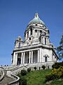
Ashton Memorial, Lancaster
-
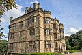
Gawthorpe Hall, Burnley, an Elizabethan country house.
-
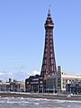
Blackpool Tower, completed in 1894
-
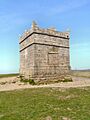
Rivington Pike, near Horwich, atop the West Pennine Moors, is one of the most popular walking destinations in the county; on a clear day the whole of the county can be viewed from here.
-
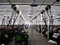
Queen Street Mill, the world's only surviving steam-driven cotton weaving shed, located in Burnley


.jpg)


See also
 In Spanish: Lancashire para niños
- Grade I listed buildings in Lancashire
- Grade II* listed buildings in Lancashire
- Lancashire dialect
- Lord Lieutenant of Lancashire
- Scheduled monuments in Lancashire
- Roses rivalry
