
River Lune facts for kids
Quick facts for kids River Lune |
|
|---|---|

The River Lune, Lancaster
|
|
| Country | England |
| Counties | Cumbria, Lancashire |
| Physical characteristics | |
| Main source | Newbiggin-on-Lune, Ravenstonedale, Cumbria 238 m (781 ft) |
| River mouth | Plover Scar, Lancaster, Lancashire 53°59′6″N 2°52′39″W / 53.98500°N 2.87750°W |
| Length | 85.6 km (53.2 mi) |
The River Lune is a river in Cumbria and Lancashire, England. It is about 85.6 km (53.2 mi) long. The river's name might come from an old British word meaning "full" or "pure." It could also be linked to an ancient Roman-British god named Ialonus, who was worshipped in the area.
Contents
Where the River Lune Begins
The River Lune starts as a small stream at St. Helen's Well in Newbiggin-on-Lune, Ravenstonedale, Cumbria. This spot is about 238 meters (781 feet) above sea level. In its first two miles, several other streams join it, making it grow bigger. One important stream is Weasdale Beck, which is considered the very beginning of the River Lune by the Environment Agency.
The River's Journey and Valleys
The River Lune flows through south Cumbria. Along its way, it passes the remains of an old Roman fort near Low Borrowbridge. The river then continues its journey until it reaches the Irish Sea at Plover Scar, near Lancaster.
The valley where the Lune flows has three main parts:
- Lunesdale: This is the northern part, from where the river starts to a town called Tebay.
- Lune Gorge: This is a dramatic, narrow valley. Both the M6 motorway and the West Coast Main Railway Line run through this gorge.
- Lonsdale: After the gorge, the valley widens out into this area.
Famous Bridges and Beauty Spots
Many bridges cross the River Lune. Some well-known ones include:
- Devil's Bridge: This historic bridge is near Kirkby Lonsdale.
- Lune Millennium Bridge: A modern bridge for walkers and cyclists in Lancaster.
At a place called Caton, about 8 kilometers (5 miles) upstream from Lancaster, you'll find a special spot called the Crook o' Lune. Here, the river makes a big 180-degree turn, then another 90-degree turn, looking like a shepherd's crook. This beautiful area was even painted by the famous artist J. M. W. Turner. There are three bridges here: one stone road bridge and two old iron railway bridges that are now used as paths for walking and cycling.
The M6 motorway crosses the Lune near Tebay and Halton-on-Lune. Another road, the Heysham to M6 Link Road, also crosses it. An old railway line, the Ingleton branch line, used to follow the Lune between Tebay and Kirkby Lonsdale, crossing the river twice on large bridges called viaducts, which are still standing today.

The River's End: The Estuary
Near the end of the river, where the tides start to affect the water, stands the Lune Aqueduct. This amazing structure carries the Lancaster Canal over the River Lune. The Lune only has tides below Skerton Weir in Lancaster.
In Lancaster, four bridges are close together, crossing the river's estuary:
- Skerton Bridge: A road bridge.
- Greyhound Bridge: Originally a railway bridge, it now carries a road.
- Lune Millennium Bridge: For pedestrians and cyclists.
- Carlisle Bridge: Carries the West Coast Main Line railway and has a public walkway. It's the furthest bridge downstream.
This part of the Lune was once a very important port for Lancaster, possibly since Roman times. To help ships navigate, the Lancaster Port Commission was set up in 1750. They built quays (docks) in Lancaster and later extended the port closer to the sea at Glasson Dock. In 1847, two lighthouses were built near Cockersand Abbey to guide ships. The Plover Scar Lighthouse is still there and working today.
The city of Lancaster, and the county of Lancashire, are both named after the River Lune. Even the old area called Lonsdale gets its name from the river. The river is also recognized as a County Biological Heritage Site, meaning it's important for its wildlife and nature.
The Lune in Books
The River Lune has inspired writers and artists.
- An old picture called 'The Vale of Lonsdale' appeared in a book in 1832, with a poem by Letitia Elizabeth Landon.
- A book titled Quaker Pioneers in Russia by Jane Edmondson was originally called "From the Lune to the Neva." This title showed the journey of her parents, who came from the Lune river area, to the Neva River in St. Petersburg, Russia. They were part of a Quaker group helping to drain marshes there.

Images for kids
-
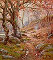
A November Morn in the Lune Valley by Reginald Aspinall
-
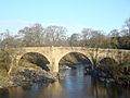
Devil's Bridge over the River Lune in Kirkby Lonsdale
-
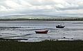
Near the mouth of the Lune, at Sunderland Point
-
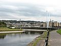
Lune at the Lune Millennium Bridge, with Lancaster in background
-
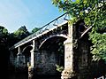
Disused railway bridge at the Crook o' Lune, once part of the "little" North Western Railway, now a cycle path
-
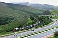
Lune Gorge


See also
 In Spanish: Río Lune para niños
