Kirkby Lonsdale facts for kids
Quick facts for kids Kirkby Lonsdale |
|
|---|---|
| Town and civil parish | |
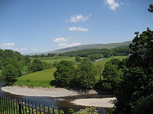 Ruskin's View |
|
| Population | 1,843 (2011 Census) |
| OS grid reference | SD6178 |
| Civil parish |
|
| Unitary authority |
|
| Ceremonial county | |
| Region | |
| Country | England |
| Sovereign state | United Kingdom |
| Post town | CARNFORTH |
| Postcode district | LA6 |
| Dialling code | 015242 |
| Police | Cumbria |
| Fire | Cumbria |
| Ambulance | North West |
| EU Parliament | North West England |
| UK Parliament |
|
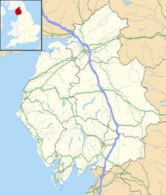
Kirkby Lonsdale is a charming town in Cumbria, England. It sits right by the River Lune. Long ago, it was part of Westmorland.
The town is about 13 miles (21 km) south-east of Kendal. In 2011, about 1,843 people lived there.
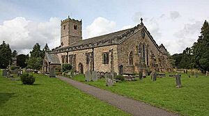
One famous spot is St Mary's Church. It's a very old building with amazing Norman designs. From the churchyard, you can see a beautiful view of the River Lune. This view is called Ruskin's View. It was named after John Ruskin, who thought it was one of England's prettiest sights. Even the famous artist J. M. W. Turner painted it!
Contents
How Kirkby Lonsdale is Governed
Kirkby Lonsdale is part of the Westmorland and Lonsdale area for the UK Parliament. This is where people vote for someone to represent them in the government. Currently, Tim Farron is the Member of Parliament (MP) for this area. He belongs to the Liberal Democrats political party.
For local decisions, the town is part of Westmorland and Furness. The town also has its own local group called the Kirkby Lonsdale Town Council. This council helps make decisions about local services and issues in the town.
Kirkby Lonsdale's Early History
People have lived in the Kirkby Lonsdale area for a very long time. We know this because of old discoveries. For example, a stone circle from the Neolithic period (the New Stone Age) was found on Casterton Fell. There are also signs of ancient Celtic villages nearby.
Roman Times in Kirkby Lonsdale
During the time of the Roman Empire, a Roman road ran along the River Lune. This road connected Roman forts in the area. One important discovery was a Roman milestone in 1836. This stone helped mark distances along the Roman road. It was put back up near where it was found.
Kirkby Lonsdale grew because it was a good place to cross the River Lune. Many paths used by animal herders and people with pack-horses met here. The town is even mentioned in the Domesday Book from 1086. This was a big survey ordered by William the Conqueror. In the book, Kirkby Lonsdale was called Cherchibi, meaning "village with a church."
Norman Influence and the Market
The original church was rebuilt by the Normans. They also built a small hill called a motte nearby. A wooden tower or fort likely stood on top of this hill. This helped them control the area.
Later, this hill was used for cockfighting, which is why it's now called Cockpit Hill. In 1093, the church was given to St Mary's Abbey in York. It stayed with the abbey until the Dissolution (when monasteries were closed down). After that, the church became part of Trinity College, Cambridge.
In 1227, Kirkby Lonsdale was given a special permission called a market charter. This allowed the town to hold a weekly market and an annual fair every September. People would gather in Market Street to sell their goods. There were even special areas for selling horses and pigs. Thursdays are still busy market days in Kirkby Lonsdale.
Kirkby Lonsdale in the 19th Century and Today
The weekly market and the many travelers passing through made Kirkby Lonsdale a very busy place. At one point, there were 29 inns and places to drink! Today, eight of these old inns still remain. By the early 1800s, the old market area was too crowded. So, a new market place was built in 1822.
Mill Brow, a steep street with a fast-flowing stream (now underground), was the town's industrial center. Many mills used water power there. They ground corn, processed wool, made snuff, and sawed timber.
Roads were also improved. The Keighley and Kendal Turnpike road, built in 1753, passed through Kirkby Lonsdale. It met another important road from Milnthorpe. Later, in 1861, Kirkby Lonsdale railway station opened about 2 miles (3.2 km) away. However, it closed to passengers in 1954.
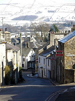
Today, Kirkby Lonsdale is still a lively market town. The town center has a mix of beautiful 18th-century buildings and old stone cottages. These cottages are found around cobbled courtyards and narrow paths. Some of these paths have fun names like Salt Pie Lane and Jingling Lane.
St Mary's Church is still an active church today. It is known for its Norman architecture and is a very important historic building.
Kirkby Lonsdale also has a secondary school called Queen Elizabeth School, Kirkby Lonsdale. It specializes in performing arts, sports, and languages.
The town used to host a two-day Victorian fair every September. The streets would be closed to cars and filled with market stalls and craft displays. Visitors were encouraged to dress in Victorian clothes.
Motorbike fans often meet up every Sunday at a famous spot called Devil's Bridge.
Devil's Bridge: History and Legend
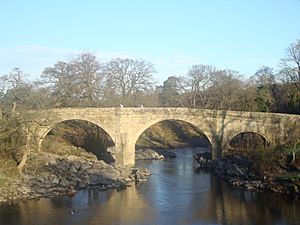
The town is famous for the Devil's Bridge. This old bridge, built around 1370, once carried a main road over the River Lune. It is made of strong stone. The bridge has three arches, and its piers (the supports) are shaped like hexagons. At one end, there's even a sundial! Monks from St Mary's Abbey, York likely built this impressive bridge.
The Legend of Devil's Bridge
Like many bridges with the same name, Devil's Bridge has a fun legend. The story says that the Devil appeared to an old woman. He promised to build the bridge if he could have the first soul to cross it. When the bridge was finished, the clever woman threw bread over it. Her dog then ran across to get the bread, tricking the Devil!
Some large stones in the area are also part of the legend. People say they fell from the Devil's purse as he carried stones to build the bridge.
Modern Use of Devil's Bridge
The roadway on the bridge is only 12 feet (3.7 m) wide. This is too narrow for today's cars and trucks. So, in 1932, the bridge was closed to vehicles. Cars now use the Stanley Bridge, which was built in the 1930s, about 490 feet (150 m) south of Devil's Bridge. Devil's Bridge is now a protected historic structure.
The river under Devil's Bridge is popular with scuba divers. It's easy to get in and out, and there are deep pools. However, it's important to know that jumping from the bridge (sometimes called "tombstoning") can be very dangerous and has led to serious accidents.
Lee Child and the Jack Reacher Connection
Did you know that a very famous thriller writer, Lee Child, lived in Kirkby Lonsdale? He is the author and creator of the popular Jack Reacher book series. He was living in the town when he wrote his very first novel, Killing Floor.
In 1994, Lee Child's real name was Jim Grant. He had just lost his job as a television executive in Manchester. He decided to try writing thrillers to earn money. At the time, he lived at 10 Abbotsgate in Kirkby Lonsdale. His daughter, Ruth, even went to the Queen Elizabeth School in the town.
He chose the pen name 'Lee Child' because it was short. He wanted it to appear alphabetically between other famous authors like Raymond Chandler and Agatha Christie on bookstore shelves. He started writing his first book about a modern hero, but he didn't have a name for his character yet. Jim Grant came up with the name 'Reacher' during a shopping trip to an Asda supermarket in Kendal!
Jim Grant's favorite place to relax was the Snooty Fox pub in Kirkby Lonsdale. Once a week, he, his American wife Jane, and friends would join a pub quiz team. They played at the Pheasant Inn in nearby Casterton. It was at the Pheasant that he got an exciting phone call from a literary agent in London on December 7, 1995. This call changed his life and started his amazing writing career.
See also
 In Spanish: Kirkby Lonsdale para niños
 | John T. Biggers |
 | Thomas Blackshear |
 | Mark Bradford |
 | Beverly Buchanan |


