
Ravenstonedale facts for kids
Quick facts for kids Ravenstonedale |
|
|---|---|
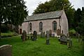
 St Oswalds Church in Ravenstonedale |
|

Ravenstonedale
|
|
| Population | 594 (2011) |
| OS grid reference | NY723040 |
| Civil parish |
|
| District | |
| Shire county | |
| Region | |
| Country | England |
| Sovereign state | United Kingdom |
| Post town | KIRKBY STEPHEN |
| Postcode district | CA17 |
| Dialling code | 01539 |
| Police | Cumbria |
| Fire | Cumbria |
| Ambulance | North West |
| EU Parliament | North West England |
| UK Parliament |
|
Ravenstonedale is a lovely village and a big area called a civil parish in Cumbria, England. It sits between two rivers, the River Lune and the River Eden. The village is about 4 miles (6.4 km) southwest of a town called Kirkby Stephen. The parish also includes a village called Newbiggin-on-Lune and other smaller places like Bowderdale and Weasdale.
Big areas of open moorland are part of the parish. These moors stretch about 5 miles (8 km) southwest of the village towards the Howgill Fells. In 2011, about 594 people lived in the parish. Ravenstonedale was once known as "Russendale." The parish is split into four parts called 'angles': Town, Newbiggin-on-Lune, Bowderdale, and Fell End. This area was historically part of Westmorland county. Since 2016, it has been part of the beautiful Yorkshire Dales National Park.
Contents
Village Life
The main part of Ravenstonedale village has one main street. However, many homes are spread out around the edges. A bit southeast of the village centre are the buildings of the old Ravenstonedale Endowed School. This school closed in 2015. The village has two inns, which are like small hotels or pubs. There is also another inn about two miles away at Fell End.
St Oswald's Church and Priory
The main church in the parish is called St Oswald's Church. It is named after Saint Oswald of Northumbria. Most of the church was rebuilt in the 1700s. The church tower was built in 1738, and the rest of the building was finished in 1744. Inside, it has an interesting design. Rows of box pews (like private seating areas) face a central aisle. This style is called "collegiate." The church also has a very good example of a "three-decker pulpit." This is a tall pulpit with three levels for different speakers.
North of the church, you can see the dug-up remains of a Gilbertine priory. A priory is a type of monastery. This one was built in the 1100s. You can still visit the site and learn about it from an information board.
How the Village is Run
Ravenstonedale has its own electoral ward. An electoral ward is an area used for local elections. This ward stretches north to Great Strickland. In 2011, about 976 people lived in this ward.
Getting Around
The village is located just off the A685 road. This road connects to Junction 38 of the M6 at Tebay. It also goes through Kirkby Stephen and links up with the A66 at Brough.
Ravenstonedale used to have its own train station, called Ravenstonedale railway station. It was located west of Newbiggin-on-Lune. However, it stopped taking passengers in 1952 and closed completely for goods in 1962. The closest train station now is Kirkby Stephen railway station. It is about 4 miles (6.4 km) away by road. This station is on the main Settle-Carlisle Line, which is a famous railway route. Ravenstonedale is also the northern end of the Pennine Bridleway. This is a long path for horse riders, cyclists, and walkers.
Notable People
Images for kids
-
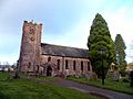
St Oswald's church
-
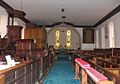
St Oswald's church interior east
-
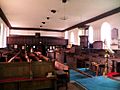
St Oswald's church interior west
-
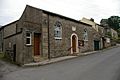
Low Chapel Methodist church
-
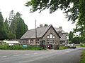
Village Endowed School
-
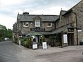
The Black Swan
-
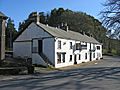
The King's Head
-
High Chapel, formerly the United Reformed Church, now the Community and Heritage Centre.


