
Blackburn with Darwen facts for kids
Quick facts for kids
Borough of Blackburn with Darwen
|
||
|---|---|---|
|
Borough and unitary authority
|
||
|
||
|
||
| Motto(s): | ||

Blackburn with Darwen shown within Lancashire
|
||
| Sovereign state | United Kingdom | |
| Country | England | |
| Region | North West | |
| Ceremonial county | Lancashire | |
| Incorporated | 1 April 1974 | |
| Unitary authority | 1 April 1998 | |
| Named for | Blackburn and Darwen | |
| Administrative HQ | Blackburn Town Hall | |
| Government | ||
| • Type | Unitary authority | |
| • Body | Blackburn with Darwen Borough Council | |
| Area | ||
| • Total | 52.9 sq mi (137.0 km2) | |
| Area rank | 196th | |
| Population
(2005 est.)
|
||
| • Total | 149,696 | |
| • Rank | 139th | |
| Ethnicity (2021) | ||
| • Ethnic groups |
List
|
|
| Religion (2021) | ||
| • Religion |
List
38.0% Christianity
35.0% Islam 21.1% no religion 0.3% Hinduism 0.2% Buddhism 0.1% Sikhism 0.0% Judaism 0.3% other 5.0% not stated |
|
| Time zone | UTC+0 (GMT) | |
| • Summer (DST) | UTC+1 (BST) | |
| Postcode areas |
|
|
| Dialling codes | 01254 | |
| ISO 3166 code | GB-BBD | |
| GSS code | E06000008 | |


Blackburn with Darwen is a special area in North West England. It is part of the larger county of Lancashire. This area is called a borough and a unitary authority. This means it has its own local government, the Blackburn with Darwen Borough Council. This council manages most local services, like schools and roads.
The borough includes the towns of Blackburn and Darwen. It also has many villages, such as Lower Darwen, Feniscowles, Brownhill, and Hoddlesden.
Contents
How Blackburn with Darwen Was Formed
This area was created in 1974. Back then, it was known as the borough of Blackburn. It was made up of the old areas of Blackburn and Darwen. It also included parts of nearby rural districts.
In May 1997, its name was changed to Blackburn with Darwen. This was done to prepare for a big change. On April 1, 1998, it became a unitary authority. This means it became fully responsible for its own local services, separate from the main Lancashire County Council.
Who Lives in Blackburn with Darwen?
Blackburn with Darwen is home to a diverse population. According to the 2021 census, about 60% of people are from a White background. Around 36% are from an Asian background. Smaller groups include people of Mixed or Black heritage.
Religion in the Area
The 2021 census also showed the different religions practiced here. About 38% of people are Christian. A large group, 35%, are Muslim. Many people, 21%, said they had no religion. Other religions like Hinduism and Buddhism are also present.
Religion in Blackburn with Darwen as of 2021 Christianity (38.0%) Islam (35.0%) Hinduism (0.3%) Buddhism (0.2%) Sikh (0.1%) No religion (21.1%) Not stated (5.0%) Other (0.3%)
How the Area is Governed
The main office for the council is at Blackburn Town Hall. It is located in the center of Blackburn. As a unitary authority, the Blackburn with Darwen Borough Council provides most local services. This includes things like managing schools, libraries, and local roads.
Some smaller parts of the borough have their own local councils. These are called civil parishes. They help with very local matters.
Economy of Blackburn with Darwen
The economy of Blackburn with Darwen has changed over time. In 1995, a large part of its economy came from industry. This includes factories and manufacturing. Over the years, the importance of industry has decreased a little.
At the same time, the services sector has grown a lot. Services include jobs in shops, offices, healthcare, and education. Agriculture, like farming, makes up a very small part of the economy.
Towns and Villages
The borough of Blackburn with Darwen includes two main towns, Blackburn and Darwen. It also has many smaller villages and communities. These include:
- Bank Fold
- Bank Hey
- Beardwood
- Belmont
- Belthorn
- Blackamoor
- Brownhill
- Cadshaw
- Chapeltown
- Cherry Tree
- Edgworth
- Entwistle
- Feniscowles
- Grimshaw
- Guide
- Hoddlesden
- Little Harwood
- Lower Darwen
- Pickup Bank
- Pleasington
- Tockholes
- Waterside
- Whalley Range
- Whitebirk
Some of these villages have their own local councils, called civil parishes. These include Darwen, Eccleshill, Livesey, North Turton, Pleasington, Tockholes, and Yate and Pickup Bank.
Education in the Borough
Since Blackburn with Darwen is a unitary authority, its council is in charge of education. This means they are responsible for schools and making sure students get a good education within the borough.
Transport
The Blackburn with Darwen Council has a plan for transport. They aim to make roads "traffic free" where possible. This helps to reduce traffic and make the area safer and cleaner.
Special Honours
The borough of Blackburn with Darwen gives out a special honour called the "Freedom of the Borough". This is given to important people or military groups. It is a way to show great respect and thanks.
Individuals Honoured
- Barbara Castle: November 23, 1979
- Sir Charles Fletcher-Cooke: November 23, 1979
- Tom Taylor, Baron Taylor of Blackburn: April 2, 1992
- Jack Straw: October 1, 2015
Military Units Honoured
- The East Lancashire Regiment: February 5, 1948
- The Lancashire Regiment: November 6, 1958
- The Queen's Lancashire Regiment: March 25, 1970
- The Duke of Lancaster's Regiment: July 1, 2006
Images for kids
-
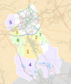
Map showing the civil parishes within Blackburn with Darwen.

See also
 In Spanish: Blackburn with Darwen para niños
