
River Wyre facts for kids

The River Wyre is a river in Lancashire, England, United Kingdom. It flows into the Irish Sea at Fleetwood. The river is about 28 miles (45 kilometers) long. It's a special place called a County Biological Heritage Site because it has a very wide and calm estuary. An estuary is where a river meets the sea. This estuary covers many square miles and is the main waterway in an area called the Fylde, which is a peninsula in Lancashire.
Contents
What Does the Name Wyre Mean?
The name Wyre is very old, even older than the Roman times in Britain. It likely comes from an ancient language called Common Brittonic. The name might mean "flowing" or "winding river." Other rivers, like the River Wear in County Durham and the Quair Water in Scotland, might share a similar name origin.
Where Does the River Wyre Flow?
The River Wyre starts in the Forest of Bowland in central Lancashire. It begins as two smaller streams, the Tarnbrook Wyre and the Marshaw Wyre. These two streams join together near a village called Abbeystead.
In 1984, a pumping station was built near Abbeystead to help move water. Sadly, there was a big explosion there, known as the Abbeystead disaster, which killed 16 people and injured 22 others.
From Abbeystead to the Sea
From Abbeystead, the river flows south through Dolphinholme to Garstang. At Garstang, the Lancaster Canal crosses over the river on a small bridge designed for boats, called an aqueduct.
About a mile south, at Catterall, the River Wyre meets its first big helper river, the River Calder. The Wyre then turns west and flows through St Michael's On Wyre. Here, another important river, the River Brock, joins it. Below a small dam at St Michael's, the river becomes tidal, meaning its water level goes up and down with the ocean tides.
Bridges and Ferries on the Wyre
The river is crossed by a toll bridge at Cartford, between Little Eccleston and Out Rawcliffe. You have to pay a small fee, usually 50 pence, to cross it.
Another bridge, Shard Bridge, near Poulton-le-Fylde, used to be a toll bridge but has been rebuilt and is now free to cross.
There's also a small boat, a pedestrian ferry, that takes people between Fleetwood and Knott End. In the past, there was even a ferry that went all the way to the Isle of Man, but it doesn't run anymore.
Industry and Nature Along the River
Near the mouth of the river, at a place called Burn Naze, there used to be a large factory site owned by ICI. This factory made chemicals using salt water from mines across the river in Preesall. While ICI is no longer there, some industrial work still happens by the river, but on a much smaller scale.
The area around Burn Naze was once called Bergerode. This old name likely meant "shallow harbor" in Old English.
From Skippool, which is just past Shard Bridge, all the way to Fleetwood, the riverbanks are part of the Wyre Estuary Country Park. This park has facilities for visitors and its main office is at Stanah. It has even won a Green Flag Award, which means it's a well-managed and welcoming green space.
Fleetwood: A Fishing Town
Fleetwood, located where the river meets the sea, was once a very important fishing port. Wyre Dock was built there between 1869 and 1877 to handle all the fishing boats. As the number of fishing boats decreased, much of the dock area has been turned into a marina for leisure boats and a shopping area called "Freeport."
How Big is the Wyre's Area?
The River Wyre collects water from a total area of about 175 square miles (450 square kilometers). The part of the river that is affected by tides, below Cartford Bridge, drains an area of about 125 square miles.
The Wyre is special because it's the only major river in Lancashire that starts and finishes entirely within Lancashire. Other big rivers like the River Ribble start in Yorkshire, and the River Lune begins in Cumbria.
Images for kids
-
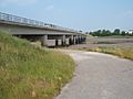
Shard Bridge spans the River Wyre between Hambleton and Singleton
-
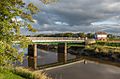
Cartford Bridge spanning the river


