
Forest of Bowland facts for kids
Quick facts for kids Forest of Bowland |
|
|---|---|

Ward's Stone is the highest point in the Forest of Bowland at 1,841 feet (561 m).
|
|

The Forest of Bowland AONB shown (in green) with the district boundaries of Lancashire
|
|
| Location | England |
| Established | 1964 |

The Forest of Bowland, also known as the Bowland Fells, is a beautiful area in northern England. It has many hills, deep valleys, and wide open spaces covered in peat and heather. Most of it is in Lancashire, but a small part is in North Yorkshire. It's like a western edge of the larger Pennines mountain range.
In 1964, the Forest of Bowland was named an Area of Outstanding Natural Beauty (AONB). This means it's a special place with amazing landscapes that are protected. The AONB also includes a separate area called the Forest of Pendle, which is known for Pendle Hill. There are over 500 historic buildings and 18 ancient monuments in the AONB.
The Trough of Bowland is a pass that cuts through the hills. It connects two river valleys and divides the main part of Bowland into two sections.
Contents
Exploring the Bowland Hills
The hills on the western side of the Forest of Bowland are very popular for walkers. People from nearby Lancaster love to explore them. The hills form a big horseshoe shape, open towards the west.
Some of the main hills you can find here are:
- Clougha Pike (413 meters or 1,355 feet)
- Grit Fell (468 meters or 1,535 feet)
- Ward's Stone (561 meters or 1,841 feet)
- Wolfhole Crag (527 meters or 1,729 feet)
- White Hill (544 meters or 1,785 feet)
- Whins Brow (476 meters or 1,562 feet)
- Totridge (496 meters or 1,627 feet)
- Parlick (432 meters or 1,417 feet)
- Fair Snape Fell (510 meters or 1,673 feet)
- Bleasdale Moor (429 meters or 1,407 feet)
- Hawthornthwaite Fell (478 meters or 1,568 feet)
Did you know that the geographic center of Great Britain is located in the Forest of Bowland? It's near the Whitendale Hanging Stones, about 4 miles (6 km) north of Dunsop Bridge.
A Look at Bowland's Past
The Forest of Bowland has a long and interesting history. It was once part of an ancient British kingdom called Rheged. Later, it became part of Northumbria and then was taken over by the Norse people.
In 926, King Æthelstan of the West Saxons took control of the area. He later gave a large part of it to the Archbishop of York. The name "Bowland" comes from an old Norse word, boga- or bogi-, which means "a bend in a river." This describes the winding rivers and streams in the area.
Before the Normans arrived, Bowland was owned by Tostig, the son of Earl Godwin. After the Norman Conquest, King William Rufus gave the area to his follower, Roger de Poitou. This is when the Forest and Liberty of Bowland were officially created.
Later, the area became part of the Honor of Clitheroe, a large estate. In 1311, it joined the Earldom of Lancaster, and from 1351 to 1661, it was managed by the Duchy of Lancaster. By the late 1300s, Bowland was a large royal hunting ground covering almost 300 square miles (777 km²).
In 1661, the land was given to General George Monck, a key figure in bringing King Charles II back to the throne. The ownership then passed through several important families.
The Bowbearer's Role
Since the 12th century, special people called Bowbearers have been appointed in the Forest of Bowland. Originally, a Bowbearer was a noble who carried the king's hunting bow in ceremonies. Over time, their role changed. In 2010, the current Lord of Bowland brought back this old tradition and appointed a new Bowbearer after almost 150 years!
Old Forest Courts
The Forest of Bowland used to have its own special courts, called woodmote and swainmote. These courts dealt with issues related to the forest. They stopped being used in the 1830s.
St. Hubert's Chapel
St Hubert, who is the patron saint of hunting, is also the patron saint of the Forest of Bowland. There's a chapel dedicated to him in Dunsop Bridge. It was built by Richard Eastwood, who was the last known Bowbearer before the office was revived.
World War II Training
During the Second World War, parts of the Bowland Fells were used for military training. Because of this, there are still some unexploded bombs in certain areas, so it's important to be careful.
Nature and Wildlife
The word "forest" here doesn't mean it's covered in trees. It means it was once a "royal hunting ground." Most of the land is actually heather moorland and blanket bog. Long ago, animals like wild boar, deer, wolves, and wild cats lived here. The last wild deer herd was said to have disappeared in 1805.
Grouse Shooting
The Forest of Bowland is an important place for grouse shooting. The Abbeystead estate holds a record for the most grouse shot in one day: 2,929 birds were shot by eight hunters on August 12, 1915!
Protected Wildlife Areas
A large part of the Bowland Fells, about 38,940.5 acres (15,758 hectares), is a Site of Special Scientific Interest. This area is very important for its upland birds. It's also a Special Protection Area because it's a key breeding ground for birds like the merlin and the hen harrier.
Hen Harriers: A Special Bird
The hen harrier is the symbol of the AONB. Sadly, in the Forest of Bowland and other upland areas of England, these birds are in danger from illegal hunting. In 2013, no hen harriers bred in England at all.
The RSPB (Royal Society for the Protection of Birds) believes that grouse shooting estates should have licenses. If crimes are committed on these estates, their right to operate should be taken away. A book called Bowland Beth: The Life of an English Hen Harrier (2017) talks about the problems hen harriers face on the grouse moors here.
Helping Hen Harriers Recover
Good news! In 2014, the Forest of Bowland became part of a special European Union project. This project aims to help hen harriers have a safe future in England and Scotland. It works with landowners and hunters to find solutions. In 2015, a single chick successfully left its nest in the Forest. In 2018, two more nests were found on land owned by United Utilities, and volunteers helped protect them.
Bowland's Landscape
The Forest of Bowland is mostly made up of high hills called fells. These fells are covered with heather and blanket bog. On the lower parts of the hills, you'll see stone farms and small villages. Drystone walls criss-cross the landscape, separating fields.
Steep, wooded valleys connect the high hills to the lower lands. In the northeast, there are large areas of pine trees. The eastern parts have meadows full of different plant species. There are also caves in the area, like Hell Hole. The fells are surrounded by the Yorkshire Dales and South Pennines.
Rocks and Geology
The Forest of Bowland is mainly made of different types of rock like sandstone, mudstone, and siltstone. These rocks formed during the late Carboniferous period. Older rocks, like limestone, are found deeper underground and also appear on the surface around the southeastern edge of the area.
The different types of sandstone form the peaks of many hills. For example, Ward's Stone and Clougha Pike are made of Ward's Stone Sandstone. White Hill is formed from Dure Clough Sandstone.
Visitor Information
If you want to learn more about the Forest of Bowland, you can visit the Bowland Visitor Centre. It's located in Beacon Fell Country Park. The center gives visitors information about the AONB and the surrounding countryside.
There's also a display about the nature of the Forest of Bowland at the Clitheroe Castle Museum.
Fun Events
The Bowland Challenge was a fundraising event held from 2006 to 2009, and again in 2011. Teams of walkers used maps to find their way around the area for ten hours. This event raised money for the Bowland Pennine Mountain Rescue Team.
You can also find "Crafty Vintage" Festive Markets every December at Wyresdale Park, near the village of Scorton. And if you like car rallies, Nicky Nook Fell in Wyresdale Park hosts a stage of the North West Stages car rally, with special areas for spectators to watch.
Bowland in Books and TV
The Forest of Bowland has inspired many artists and writers:
- Composer Christopher Gibbs wrote a Forest of Bowland Suite of music.
- W. G. Rigby's children's book The Ring of Tima (1998) is set here.
- Poet Jane Routh's 2014 collection Falling into Place is also set in the Forest of Bowland.
- Dennis Watkins-Pitchford's 1955 fantasy book Forest of Boland Light Railway takes place in a forest inspired by Bowland.
- Wyresdale Park has been featured on TV shows like Drew Pritchard's Salvage Hunters (2017) and Channel 4's Country House Rescue (2011).
Images for kids
-
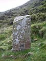
The Lancashire side of the Grey Stone of Trough
-
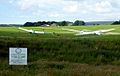
Bowland Forest Gliding Club, looking north-west

.jpg)
