
Parlick facts for kids
Quick facts for kids Parlick |
|
|---|---|

Viewed from Beacon Fell Road
|
|
| Highest point | |
| Elevation | 432 m (1,417 ft) |
| Prominence | c. 34 m |
| Geography | |

Parlick
Location in the Forest of Bowland

Parlick
Location in Lancashire

Parlick
Location in the Borough of Wyre

Parlick
Location in the Borough of Ribble Valley
|
|
| Location | Lancashire, England |
| Parent range | Forest of Bowland |
| OS grid | SD599453 |
| Topo map | OS Landranger 102 |
Parlick, also known as Parlick Pike, is a hill in Lancashire, England. It's shaped a bit like a cone and has steep sides. Parlick is located at the very southern end of the main Forest of Bowland fells.
Many people enjoy hiking on Parlick because its paths are not muddy like some other hills nearby. You can find different paths to climb Parlick. Some zigzag up, while others are straight and more challenging. Unlike some hills that look brown or red, Parlick is usually green. A narrow ridge connects Parlick to another hill called Fair Snape Fell, and there are clear paths between them.
Contents
What's in a Name?
The name 'Parlick' has an interesting history. Experts believe it might come from old English words. One idea is that it means "pear orchard" or "pear tree." Another thought is that it refers to a "sheep fold" (a pen for sheep) where a pear tree grew. This place might have been at the bottom or on the side of the hill, giving the hill its name.
Flying High at Parlick
Parlick is a very popular spot for people who enjoy flying with gliders. These are special aircraft that don't have engines, like paragliders. The hill is great for this because it creates good "ridge lift." This is when wind blows up the side of the hill, helping gliders stay in the air.
Pilots can fly over a wide area, even reaching Beacon Fell without losing the helpful wind. Local flying clubs often hold competitions here, like the "Parlick Grid Challenge."
Amazing Views from the Top
When you reach the top of Parlick, you'll find a small pile of stones called a cairn. From here, you can enjoy some fantastic views!
- Looking south, you can see the towns of Preston and Chorley, along with Winter Hill.
- To the east, you can spot Pendle Hill.
- To the west, you might even see Blackpool and the Irish Sea.
The hill is split between two local areas: the Wyre and Ribble Valley boroughs. About half of Parlick is in each one.
Parlick Fell Cheese
Did you know there's a cheese named after this hill? "Parlick Fell" is a type of cheese made in a town called Longridge. It's special because it's made from sheep's milk from the local area.
The Legend of the Dun Cow
Parlick is also part of an old local story about a giant cow! This legendary cow, called the Dun Cow, was said to wander freely across the moorland. The story says she would often drink water from a well on the very top of Parlick, known as "Nick's Water-Pot."
Images for kids
-
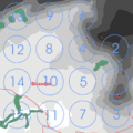
Layout of the "Parlick Grid Challenge". Parlick is bottom right, between grid locations 1 and 3.

