Trough of Bowland facts for kids
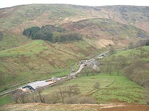
The Trough of Bowland is a beautiful valley and a high road in the Forest of Bowland. This area is a special place called an Area of Outstanding Natural Beauty in Lancashire, England.
The road through the Trough goes up to about 295 meters (968 feet) above sea level. It connects to a place called Wyresdale. This road divides the high hills of Bowland into two main parts. Even though it's steep and narrow, it's the quickest way to get from Lancaster to Dunsop Bridge and then to Clitheroe. Long ago, in 1612, the famous "Pendle witches" used this very road when they were taken to their trial at Lancaster Castle.
At the top of the pass, there's a stone called the Grey Stone of Trough. This stone used to mark the old border between Lancashire and West Riding of Yorkshire before 1974. It also showed the western edge of the ancient Lordship of Bowland.
Contents
What is the Trough of Bowland?
The Trough of Bowland is a very pretty place. Many visitors, especially people who love walking and cycling, enjoy coming here. Because it's so popular, some people think the Trough is the same as the whole Forest of Bowland. However, the Trough is actually only a small part of the much larger Area of Outstanding Natural Beauty, which covers about 808 square kilometers (312 square miles).
Where is the Trough?
The official maps, like those from the Ordnance Survey, show the Trough of Bowland as just the steep upper valley of Losterdale Brook, above a place called Trough Barn.
But most people use a wider definition. This includes:
- The main valleys of Langden Brook and its smaller streams, all the way to Dunsop Bridge.
- On the Wyresdale side of the pass, it includes the moorland and wooded valley of Trough Beck, up to Trough Bridge. Most people also include the rest of the wooded valley where the Wyre river starts, as far as Marshaw.
Life and Work in the Trough
The Trough is a very quiet place with few people living there. On the Langden side, there are only two farms, Sykes and Hareden. In Wyresdale, there is a small group of homes in Marshaw. All these places have buildings that are officially protected because they are historically important.
You can still see signs of old industries here. There's a disused lime kiln by the road, which was used to make lime. There are also several old quarry marks where stone was dug out. A building called Smelt Mill is now the main base for the Bowland Pennine Mountain Rescue Team. They help people who get lost or hurt in the mountains.
Water for the City
Water from the main streams in the Trough is used to supply the city of Preston. In the 1920s, special water intakes were built at the start of Hareden, Losterdale, and Langden Brooks. These intakes are connected by a series of pipes and channels to the Alston Reservoirs near Longridge. Today, the water intakes are managed by United Utilities from their office at Stocks board house.
 | Victor J. Glover |
 | Yvonne Cagle |
 | Jeanette Epps |
 | Bernard A. Harris Jr. |


