South Pennines facts for kids
The South Pennines is a beautiful area of hills and open moorland in northern England. It sits near the southern end of the larger Pennines mountain range. To the west, you'll find the Rossendale Valley and the West Pennine Moors. The big city area of Greater Manchester is to its west, while the Bowland Fells and Yorkshire Dales are to the north. On the eastern side, there are towns in West Yorkshire, and to the south is the Peak District. The wild South Pennine Moors are so special that they are protected as a Site of Special Scientific Interest and a Special Area of Conservation.
Contents
What Makes This Area Special?
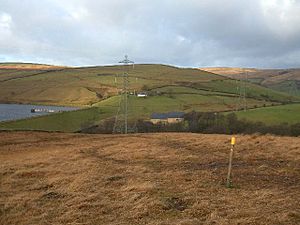
Natural England describes the Southern Pennines as a unique "National Character Area." This means it has a special look and feel. Imagine wide-open moorlands, hills with flat tops, and fields separated by walls made of dry stones. Towns here are built from local gritstone and sit in river valleys with trees along their sides.
The peaty soils and boggy areas on the moors are important. They store carbon, which helps the environment. Lots of rain falls here, filling many reservoirs. These reservoirs provide water to the nearby cities. The area is also great for outdoor fun. It has many open spaces, footpaths, and old packhorse routes for exploring.
Rocks and Land Formation
The South Pennines is mostly made of many layers of rock. These rocks formed a very long time ago during the Carboniferous period. The oldest rocks are limestones and mudstones. They are found deep underground across the whole area.
Above these older rocks are mudstones and sandstones. Many of the rougher sandstones are called 'gritstones' or 'grits'. On top of these are even younger rocks, also from the Carboniferous period. These include mudstones, siltstones, sandstones, and importantly, coal seams. You can find these coal-rich rocks along the eastern and western edges of the region. They are also found across much of the West Pennines.
Where Exactly Is It?
The South Pennines covers the Pennine area between the Yorkshire Dales, Bowland Fells, and Peak District. It is separated from the Yorkshire Dales by the Aire Gap. The Ribble Valley separates it from the Bowland Fells to the northwest. To the south, the Chew, Colne, and Holme Valleys separate it from the Peak District. The West Lancashire Coastal Plain and Greater Manchester are to the west. The West Yorkshire towns are to the east.
Towns and Villages
Many towns and villages are found within the South Pennines. In the north, you'll find Addingham, Ilkley, and Otley. Along the Calder Valley, there are places like Bingley, Keighley, Haworth, Oxenhope, Halifax, Sowerby Bridge, Hebden Bridge, and Todmorden.
To the southeast, there's Marsden, Slaithwaite, and Meltham. In Lancashire, you can visit Darwen, Haslingden, and Rawtenstall. And in Greater Manchester, there's Greenfield, Horwich, Ramsbottom, and Littleborough.
Moorlands and High Points
The South Pennines is home to several moorlands. These include Rombalds Moor, Rishworth Moor, Haworth Moor, Turton Moor, and Castleshaw Moor. The highest point of the M62 motorway is here. This is the highest motorway in England, reaching 1,221 feet (372 m) on Windy Hill.
Rivers and Canals
Rivers like the Aire, Calder, and Colne flow east from this area. The Roch and Irwell flow west. The Calder Valley provides an easy route for roads, railways, and the Rochdale Canal. This route connects Greater Manchester and Lancashire in the west with West Yorkshire to the east.
The Huddersfield Narrow Canal and the railway from Manchester to Huddersfield pass through the Standedge Tunnels. The A62 road also crosses the moorland at Standedge. The Leeds and Liverpool Canal goes through Bingley and Keighley on its way to Skipton.
Natural England calls the South Pennine moorlands the Watershed Landscape. This is because the high rainfall here fills many reservoirs. Over a million people live in the South Pennines and its surrounding areas. About 4% of the land is covered by woodland, mostly on the steep sides of the valleys.
A Look Back in Time
The South Pennines has a long and interesting history. Evidence shows people lived here during the Mesolithic (Middle Stone Age), late Bronze Age, and Iron Age. The Romans also built roads and forts here. You can still see remains of their forts in Ilkley and at Castleshaw.
The Romans even dug for coal here. Coal mining became much more important during the Industrial Revolution in the late 1700s and early 1800s.
The steep valleys and fast-flowing streams were perfect for early mills and factories. Water-powered corn mills and fulling mills were used in medieval times. More fulling mills were built after the mid-1500s as the wool industry grew. By the late 1700s, water-powered mills were key to the growth of the textile industry. They first spun cotton, then wool and worsted fabrics.
Fun Things to Do
The South Pennines is a fantastic place for outdoor activities. Walking, mountain-biking, and horseriding are very popular here. There are many walking trails to explore. Some famous ones include the Calderdale Way and the Bronte Way. The very old and well-known Pennine Way also passes through this area.
Every September, the South Pennines Walk & Ride Festival takes place. This is a two-week celebration of the area's beautiful landscape. Events often include guided walks, mountain bike rides, horse rides, and orienteering (a sport using a map and compass). There are also evening talks by interesting speakers.
 | Aaron Henry |
 | T. R. M. Howard |
 | Jesse Jackson |


