
M62 motorway facts for kids
Quick facts for kids
|
||||
|---|---|---|---|---|
| Lancashire-Yorkshire Motorway | ||||
_map.svg) |
||||

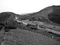
Looking east at junction 22, the highest point on the English motorway network, from the Pennine Way
|
||||
| Route information | ||||
| Part of |
||||
| Maintained by Highways England Knowsley Metropolitan Borough Council Liverpool City Council |
||||
| Length | 107 mi (172 km)
7 miles (11 km) are part of the M60 motorway
|
|||
| History | Opened: 1960 Completed: 1976 |
|||
| Major junctions | ||||
| West end | Knotty Ash | |||
J6 → M57 motorway
J35 → M18 motorway |
||||
| East end | North Cave | |||
| Location | ||||
| Counties: | Merseyside, Cheshire, Greater Manchester, West Yorkshire, North Yorkshire, East Riding of Yorkshire | |||
| Primary destinations: |
Liverpool Huyton Warrington Manchester Oldham Rochdale Huddersfield Halifax Bradford Leeds Wakefield Pontefract Goole |
|||
| Road network | ||||
|
||||

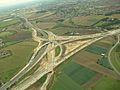
The M62 is a very important motorway in Northern England. It connects big cities like Liverpool and Manchester with Leeds and Hull. It is about 107 miles (172 km) long. About seven miles of the M62 motorway share the same road as the M60.
Contents
Connecting Cities: The M62's Path
The M62 motorway travels through many different counties. These include Merseyside, Cheshire, Greater Manchester, West Yorkshire, North Yorkshire, and the East Riding of Yorkshire.
Major Cities and Towns Along the Way
The M62 helps people travel to and from many important places. Some of the main cities and towns it connects are:
- Liverpool
- Huyton
- Warrington
- Manchester
- Oldham
- Rochdale
- Huddersfield
- Halifax
- Bradford
- Leeds
- Wakefield
- Pontefract
- Goole
How the M62 Connects to Other Motorways
The M62 links up with several other major motorways. These connections help drivers reach even more places across the country. Some key junctions include:
- Junction 6: Connects to the M57 motorway.
- Junction 10: Links with the M6 motorway.
- Junction 12: Joins the M60 motorway and M602 motorway.
- Junction 18: Meets the M60 motorway and M66 motorway.
- Junction 20: Connects to the A627(M) motorway.
- Junction 26: Links with the M606 motorway.
- Junction 27: Joins the M621 motorway.
- Junction 29: Meets the M1 motorway.
- Junction 32a: Connects to the A1(M) motorway.
- Junction 35: Links with the M18 motorway.
Interesting Facts About the M62
The M62 was opened in parts, starting in 1960. It was fully completed in 1976. It is a very busy road that helps millions of people travel across Northern England every year.
The Highest Point
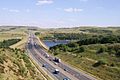
The M62 motorway reaches its highest point at Junction 22. This spot is located near the Pennine Way, a famous walking trail. It offers great views of the surrounding area.
The Ouse Bridge
A notable part of the M62 is the Ouse Bridge. This bridge crosses the River Ouse and is an important structure along the motorway.
Images for kids
-
Construction starting in Milnrow, 1968
-
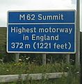
M62 Summit sign
-
Stationary traffic at Lofthouse Interchange
-
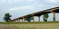
The Ouse Bridge, from the floodplain adjacent to the river
-
Junction 32a during construction in September 2005
-
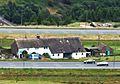
Stott Hall Farm, viewed from moorland above westbound carriageway
-
M62 passes Scammonden Water in West Yorkshire


_and_M62_interchange.jpg)
.JPG)

