
West Yorkshire facts for kids
Quick facts for kids
West Yorkshire
|
|||||||||||||||||||||||||||||||||||||||||
|---|---|---|---|---|---|---|---|---|---|---|---|---|---|---|---|---|---|---|---|---|---|---|---|---|---|---|---|---|---|---|---|---|---|---|---|---|---|---|---|---|---|
|
Aspley Basin on the Broad Canal (Huddersfield), the Piece Hall (Halifax) and Ilkley Moor (near Ilkley)
|
|||||||||||||||||||||||||||||||||||||||||

West Yorkshire within England
|
|||||||||||||||||||||||||||||||||||||||||
| Sovereign state | United Kingdom | ||||||||||||||||||||||||||||||||||||||||
| Constituent country | England | ||||||||||||||||||||||||||||||||||||||||
| Region | Yorkshire and the Humber | ||||||||||||||||||||||||||||||||||||||||
| Established | 1 April 1974 | ||||||||||||||||||||||||||||||||||||||||
| Preceded by | West Riding of Yorkshire | ||||||||||||||||||||||||||||||||||||||||
| Origin | Local Government Act 1972 | ||||||||||||||||||||||||||||||||||||||||
| Time zone | UTC±00:00 (Greenwich Mean Time) | ||||||||||||||||||||||||||||||||||||||||
| • Summer (DST) | UTC+01:00 (British Summer Time) | ||||||||||||||||||||||||||||||||||||||||
| Members of Parliament | List of MPs | ||||||||||||||||||||||||||||||||||||||||
| Police | West Yorkshire Police | ||||||||||||||||||||||||||||||||||||||||
|
|||||||||||||||||||||||||||||||||||||||||
.jpg)
.jpg)
_(edited).jpg)

West Yorkshire is a special area in England, located in the Yorkshire and the Humber region. It's known as both a metropolitan and ceremonial county. This means it has its own local government and also a special representative of the King or Queen.
West Yorkshire shares its borders with North Yorkshire to the north and east, South Yorkshire and Derbyshire to the south, Greater Manchester to the south-west, and Lancashire to the west. The biggest city in West Yorkshire is Leeds.
The county was created in 1974. It covers an area of about 2,029 square kilometers (783 square miles) and is home to 2.3 million people. This makes it the fourth-largest ceremonial county in England by population. Much of West Yorkshire is urban, meaning it has many towns and cities close together. The largest cities are Leeds (with over 516,000 people), Bradford (over 366,000), Huddersfield (over 162,000), and Wakefield (over 109,000). The western part of the county is more rural, with open countryside.
West Yorkshire is managed by five local areas called metropolitan boroughs: City of Bradford, Calderdale, Kirklees, City of Leeds, and City of Wakefield. These areas work together through the West Yorkshire Combined Authority to make decisions for the whole region.
The western side of West Yorkshire is part of the South Pennines, which are hills and valleys. A small part of the beautiful Peak District National Park is also here. This area has steep valleys and is where the River Calder starts. The Calder flows past Wakefield before joining the Aire, which goes through Leeds. As you move east, the land becomes flatter.
West Yorkshire has a rich history of industries like coal mining, wool production, and iron ore. These industries brought many people to the area over the centuries. You can still see this history in the old buildings and architecture. Many major roads, like the M1 and M62, and railways connect different parts of the county.
Contents
How West Yorkshire is Governed
West Yorkshire is governed by several important groups and councils. They work together to manage services for everyone living here.
| Body | Headquarters |
|---|---|
| West Yorkshire Combined Authority | Leeds City Centre |
| West Yorkshire Fire and Rescue Service | Birkenshaw |
| West Yorkshire Joint Services | Morley |
| West Yorkshire Police | Wakefield |
| City of Bradford Metropolitan District Council | Bradford City Hall |
| Calderdale Council | Halifax Town Hall |
| Kirklees Council | Huddersfield Town Hall |
| Leeds City Council | Leeds Civic Hall |
| Wakefield Council | County Hall, Wakefield |
In 1986, the main West Yorkshire County Council was closed down. Its five local areas then became like independent councils, managing most services themselves. However, West Yorkshire still exists as a county by law and for geographical reference.
Since 2014, the local councils have worked even more closely through the West Yorkshire Combined Authority. They share responsibilities for things like transport and improving the area. In 2021, Tracy Brabin was elected as the first Mayor of West Yorkshire. She helps lead the combined authority.
The large urban area that includes Bradford, Dewsbury, Halifax, Huddersfield, Leeds, and Wakefield is called the West Yorkshire Built-up Area. It's the fourth largest urban area in the United Kingdom.
Some services, like the West Yorkshire Police and West Yorkshire Fire and Rescue Service, cover the entire county.
Geography and Landscape

.jpg)
West Yorkshire borders Lancashire, Greater Manchester, Derbyshire, South Yorkshire, and North Yorkshire. The land here mostly consists of the Pennines hills and their lower slopes. These hills are in the west and gradually become flatter towards the east.
The western areas, like Bradford and Calderdale, are known for the beautiful scenery of the eastern Pennine slopes. The land drops down from high areas in the west to lower areas in the east. Many steep valleys cut through the landscape. A small part of the northern Peak District also extends into the south-west of Kirklees.
This area has a mix of large industries, homes, public buildings, and open countryside. Roads, canals, and railways are tightly packed together, often following the valleys. This creates amazing views between the towns and the surrounding hills. Famous artists like David Hockney have been inspired by this mix of city and country.
The carboniferous rocks further east form a rolling landscape with hills and wide valleys. Here, you can see many signs of past and present industrial activity. There are old mine buildings and areas that used to be spoil heaps but are now green. The scenery is a mix of built-up areas, industrial land, and farmed countryside.
The rivers Aire and Calder flow through the area from west to east.
History of West Yorkshire
Wakefield's main church became a cathedral in 1888. After this, Wakefield was granted city status. However, the industrial revolution greatly changed West and South Yorkshire. It led to the huge growth of Leeds and Bradford, which became the two largest cities in the area. Leeds became a city in 1893, and Bradford in 1897.
| After 1974 | Before 1974 | ||||
|---|---|---|---|---|---|
| Metropolitan county | Metropolitan borough | County boroughs | Non-county boroughs | Urban districts | Rural districts |
 West Yorkshire was formed from 53 older local government areas. |
Bradford | Bradford | Keighley | Baildon • Bingley • Denholme • Ilkley • Queensbury and Shelf •Silsden • Shipley | Skipton |
| Calderdale | Halifax | Brighouse • Todmorden | Elland • Hebden Royd • Queensbury and Shelf • Ripponden • Sowerby Bridge | Hepton | |
| Kirklees | Huddersfield • Dewsbury | Batley • Spenborough | Colne Valley • Denby Dale • Heckmondwike • Holmfirth • Kirkburton • Meltham • Mirfield | ||
| Leeds | Leeds | Morley • Pudsey | Aireborough • Garforth • Horsforth • Otley • Rothwell | Tadcaster • Wharfedale • Wetherby | |
| Wakefield | Wakefield | Castleford • Ossett • Pontefract | Featherstone • Hemsworth • Horbury • Knottingley • Normanton • Stanley | Hemsworth • Osgoldcross • Wakefield | |
West Yorkshire was officially formed as a metropolitan county in 1974. This happened because of the Local Government Act 1972. It mostly covers the central part of the older historic area called the West Riding of Yorkshire. It also included the big towns of Bradford, Dewsbury, Halifax, Huddersfield, Leeds, and Wakefield.
The county council used the historic West Riding County Hall in Wakefield. This building was opened in 1898. Since 1987, it has been the main office for Wakefield City Council.
Even though the county council was abolished in 1986, West Yorkshire is still a county. It has a Lord Lieutenant of West Yorkshire and a High Sheriff. These are important ceremonial roles.
Green Spaces in West Yorkshire
West Yorkshire has many green belt areas. These are protected lands around the urban areas. They help stop cities from spreading too much and keep natural spaces for everyone to enjoy. All the districts in the county have large parts of this green belt.
Local Connections and History
West Yorkshire has strong historical ties with Lancashire, especially due to events like the War of the Roses. The town of Todmorden used to be in Lancashire but was moved into Yorkshire in the 19th century. In 1974, some towns like Earby and Barnoldswick were moved into Lancashire.
The village of Saddleworth in Oldham was the only part of the West Riding of Yorkshire to move into Greater Manchester. However, many people in Saddleworth still feel a strong connection to Yorkshire.
People and Population

West Yorkshire is a very diverse place, with people from many different backgrounds.
| District | Area km2 | Population | Density |
|---|---|---|---|
| City of Bradford | 366.42 | 523,100 | 1,346 |
| Calderdale | 363.92 | 200,100 | 545 |
| Kirklees | 408.61 | 401,000 | 975 |
| City of Leeds | 551.72 | 761,100 | 1,360 |
| City of Wakefield | 338.61 | 321,600 | 949 |
| Metropolitan borough | Seat | Other places |
|---|---|---|
| City of Bradford |
Bradford City Hall, Bradford | Addingham, Baildon, Bingley, Burley in Wharfedale, Cottingley, Crossflatts, Cross Roads, Cullingworth, Denholme, East and West Morton, Eccleshill, Eldwick, Esholt, Great Horton, Gilstead, Harden, Haworth, Ilkley, Keighley, Manningham, Menston, Oakworth, Oxenhope, Queensbury, Riddlesden, Saltaire, Sandy Lane, Shipley, Silsden, Stanbury, Steeton, Thornbury, Thornton, Tong, Undercliffe, Wibsey, Wilsden. |
| Calderdale |
Halifax Town Hall, Halifax | Bailiff Bridge, Boothtown, Brighouse, Copley, Cragg Vale, Elland, Greetland, Hebden Bridge, Heptonstall, Hipperholme, Holywell Green, Luddendenfoot, Mytholmroyd, Norwood Green, Rastrick, Ripponden, Rishworth, Shelf, Shibden, Sowerby Bridge, Todmorden |
| Kirklees |
Huddersfield Town Hall, Huddersfield | Almondbury, Batley, Birkby, Birkenshaw, Birstall, Cleckheaton, Dalton, Denby Dale, Dewsbury, Emley, Golcar, Gomersal, Hartshead, Hartshead Moor, Heckmondwike, Holmfirth, Honley, Kirkburton, Kirkheaton, Linthwaite, Liversedge, Marsden, Meltham, Mirfield, New Mill, Norristhorpe, Roberttown, Scammonden, Shelley, Shepley, Skelmanthorpe, Slaithwaite, Thornhill |
| City of Leeds |
Leeds Civic Hall, Leeds | Allerton Bywater, Beeston, Boston Spa, Collingham, Garforth, Guiseley, Harewood, Harehills, Headingley, Holbeck, Horsforth, Hyde Park, Gipton, Kippax, Kirkstall, Ledsham, Ledston, Methley, Middleton, Morley, New Farnley, Otley, Oulton, Pool-in-Wharfedale, Pudsey, Rothwell, Rawdon, Scarcroft, Scholes, Stourton, Swillington, Walton (Leeds), Wetherby, Yeadon, Woodhouse |
| City of Wakefield |
West Riding County Hall, Wakefield | Ackworth, Alverthorpe, Castleford, Crigglestone, Crofton, Durkar, Fairburn Ings, Featherstone, Ferrybridge, Fitzwilliam, Hemsworth, Horbury, Knottingley, Newmillerdam, Normanton, Nostell, Ossett, Outwood, Pontefract, Ryhill, Sandal, Sharlston, Stanley, Walton (Wakefield), West Bretton, Wrenthorpe |
| Ethnic Group | Year | |||||||||||
|---|---|---|---|---|---|---|---|---|---|---|---|---|
| 1971 estimations | 1981 estimations | 1991 census | 2001 census | 2011 census | 2021 census | |||||||
| Number | % | Number | % | Number | % | Number | % | Number | % | Number | % | |
| White: Total | – | 96.6% | 1,937,375 | 93.7% | 1,911,618 | 91.7% | 1,842,813 | 88.6% | 1,819,818 | 81.8% | 1,801,352 | 76.6% |
| White: British | – | – | – | – | – | – | 1,798,413 | 86.5% | 1,746,295 | 78.4% | 1,693,845 | 72.0% |
| White: Irish | – | – | – | – | – | – | 18,859 | 0.9% | 14,910 | 0.7% | 13,893 | 0.6% |
| White: Gypsy or Irish Traveller | – | – | – | – | – | – | – | – | 1,660 | 0.1% | 2,311 | 0.1% |
| White: Roma | – | – | – | – | – | – | – | – | – | – | 3,982 | 0.2% |
| White: Other | – | – | – | – | – | – | 25,541 | 1.2% | 56,953 | 2.6% | 87,321 | 3.7% |
| Asian or Asian British: Total | – | – | 100,191 | 4.8% | 136,824 | 6.6% | 185,907 | 9% | 291,547 | 13.1% | 372,728 | 15.9% |
| Asian or Asian British: Indian | – | – | 29,352 | 36,762 | 42,430 | 2.0% | 53,152 | 2.4% | 62,407 | 2.7% | ||
| Asian or Asian British: Pakistani | – | – | 60,803 | 84,978 | 122,210 | 5.9% | 189,708 | 8.5% | 250,497 | 10.7% | ||
| Asian or Asian British: Bangladeshi | – | – | 3,845 | 6,344 | 8,213 | 0.4% | 15,632 | 0.7% | 20,099 | 0.9% | ||
| Asian or Asian British: Chinese | – | – | 2,912 | 3,969 | 5,734 | 0.3% | 10,783 | 0.5% | 12,516 | 0.5% | ||
| Asian or Asian British: Other Asian | – | – | 3,279 | 4,771 | 7,320 | 0.4% | 22,272 | 1.0% | 27,209 | 1.2% | ||
| Black or Black British: Total | – | – | 20,770 | 1% | 25,135 | 1.2% | 20,771 | 1% | 46,476 | 2.1% | 72,257 | 3.1% |
| Black or Black British: African | – | – | 2,236 | 2,634 | 4,216 | 0.2% | 24,685 | 1.1% | 47,888 | 2.0% | ||
| Black or Black British: Caribbean | – | – | 13,088 | 15,552 | 14,409 | 0.7% | 15,581 | 0.7% | 15,588 | 0.7% | ||
| Other Black | – | – | 5,446 | 6,949 | 2,146 | 0.1% | 6,210 | 0.3% | 8,781 | 0.4% | ||
| Mixed or British Mixed: Total | – | – | – | – | – | – | 25,081 | 1.2% | 48,126 | 2.2% | 64,947 | 2.8% |
| Mixed: White and Black Caribbean | – | – | – | – | – | – | 11,263 | 0.5% | 20,827 | 0.9% | 23,573 | 1.0% |
| Mixed: White and Black African | – | – | – | – | – | – | 1,842 | 0.1% | 4,624 | 0.2% | 7,756 | 0.3% |
| Mixed: White and Asian | – | – | – | – | – | – | 8,049 | 0.4% | 15,098 | 0.7% | 21,014 | 0.9% |
| Mixed: Other Mixed | – | – | – | – | – | – | 3,927 | 0.2% | 7,577 | 0.3% | 12,604 | 0.5% |
| Other: Total | – | – | 8,363 | 10,923 | 4,639 | 0.2% | 20,091 | 0.9% | 40,295 | 1.7% | ||
| Other: Arab | – | – | – | – | – | – | – | – | 9,212 | 0.4% | 11,515 | 0.5% |
| Other: Any other ethnic group | – | – | 4,639 | 0.2% | 10,879 | 0.5% | 28,780 | 1.2% | ||||
| Non-White: Total | – | 3.4% | 129,326 | 6.3% | 172,882 | 8.3% | 236,398 | 11.4% | 406,240 | 18.2% | 550,227 | 23.4% |
| Total | – | 100% | 2,066,701 | 100% | 2,084,500 | 100% | 2,079,211 | 100% | 2,226,058 | 100% | 2,351,579 | 100% |
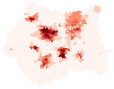
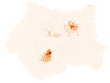
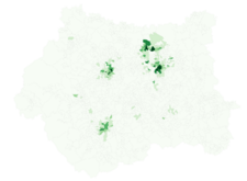
West Yorkshire is home to many different ethnic groups. For example, Bradford has a large number of British Pakistanis. Leeds and Kirklees also have many British Pakistani residents. Kirklees is also home to a large number of British Indians. West Yorkshire also has a big population of people from Eastern Europe, especially British Poles. In 2011, over 21% of West Yorkshire's population belonged to ethnic minority groups.
- Distribution of ethnic groups in West Yorkshire according to the 2021 census.
-
White (2021)
-
White-British
-
White-Irish
-
White-Other
-
Asian (2021)
-
Asian-Indian
-
Asian-Pakistani
-
Asian-Bangladeshi
-
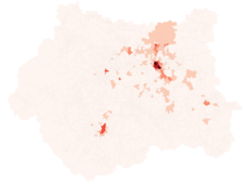
Asian-Chinese
-
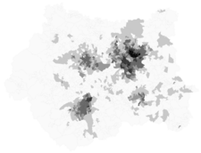
Black (2021)
-
Black-African
-
Black-Caribbean
-
Other-Arab
-

Other-Other ethnic group


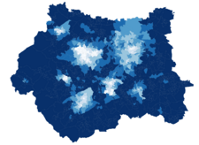
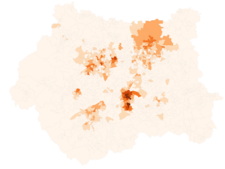
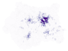
- Distribution of religions in West Yorkshire according to the 2011 census.
-
.
Christianity
-
.
Islam
-
.
Judaism
-
.
Hinduism
-
.
Sikhism
-
.
Buddhism
-
.
Other religion
-
.
No religion
Economy and Industries
West Yorkshire has a strong economy with many different types of businesses.
Key Industries in West Yorkshire
Leeds has become a major financial center. Many banks, building societies, and insurance companies have offices there. Wakefield has also attracted many service-based businesses, like call centers. Two of the UK's biggest supermarkets, Morrisons and Asda, have their main offices in West Yorkshire. Morrisons is based in Bradford, and Asda is in Leeds.
West Yorkshire grew up around several important industries. Areas like Wakefield, Castleford, Pontefract, and parts of Leeds were traditionally known for coal mining.
Wool Production
Cities like Bradford, Halifax, and Huddersfield grew a lot because of their woollen mills. Leeds was traditionally known for making cloth. Heavier engineering industries also helped South Leeds grow.
The Heavy Woollen District included towns such as Dewsbury, Batley, Morley, Ossett, Cleckheaton, and Heckmondwike. However, the wool and cloth industries became less important throughout the 20th century.
Rhubarb Farming
The Rhubarb Triangle is entirely within West Yorkshire. It still produces a lot of rhubarb. Farmers in this area successfully applied to have "Yorkshire forced rhubarb" legally protected. This means only rhubarb grown in this specific way and area can use the name. This protection helps promote the product and prevents others from using the name unfairly.
Coal Mining History
The last coal mine in West Yorkshire, Hay Royds Colliery near Denby Dale, closed in 2012 after a flood.
Filming Locations
Many films and TV shows have been filmed in West Yorkshire's historic areas, especially around Halifax. For example, parts of the BBC show Happy Valley were filmed in Huddersfield. Other shows like Jamaica Inn and Jericho have also used locations and studios in the area.
Tourism and Fun Things to Do

West Yorkshire offers many attractions for visitors. You can visit sports stadiums, museums, theaters, and art galleries. The Royal Armouries Museum is in Leeds, as are the Leeds Playhouse, Opera North, and The Grand Theatre. The First Direct Arena in Leeds can hold about 15,000 people for concerts and events.
Leeds is a very popular shopping spot, with many big stores and shopping centers like Trinity Leeds and Victoria Gate. It also has one of the biggest indoor markets in Europe. Leeds is also a popular place for nightlife.
You can enjoy walking along rivers and in the Pennine hills. The Leeds-Liverpool Canal and Rochdale Canal are great for barge trips, canoeing, or kayaking. Other fun things to do include visiting old abbeys, castles, country houses, and charming villages. You can also find tea rooms, local breweries, and farmer's markets. Popular villages for hiking include Hebden Bridge, Ilkley, and Otley.
Getting Around West Yorkshire

West Yorkshire is very well connected by roads and railways. Major motorways like the M62, M1, and A1(M) pass through the county. Leeds and Bradford also have their own urban motorways.
West Yorkshire has two main railway stations: Leeds and Wakefield Westgate. Leeds railway station is one of the busiest in the UK outside of London. Other important stations include Bradford Interchange, Huddersfield, and Halifax.
West Yorkshire is also home to Yorkshire's largest airport, Leeds Bradford Airport.
Unlike some other areas, West Yorkshire does not have a light rail system like a tram. Public transport is managed by West Yorkshire Metro. There are plans to develop a new mass transit system for the region, with significant funding announced in 2021. The area is also getting many new zero-emission electric buses.
Sports in West Yorkshire
_019.jpg)
West Yorkshire is a big area for sports, especially football and rugby league.
Football Clubs
Major football clubs in West Yorkshire include Leeds United, Huddersfield Town, and Bradford City.
Rugby League Teams
Rugby league is very popular here. Teams that play in the top league, Super League, include Bradford Bulls, Castleford Tigers, Halifax Panthers, Huddersfield Giants, Leeds Rhinos, and Wakefield Trinity. Other rugby league clubs in the county are Batley Bulldogs, Dewsbury Rams, and Featherstone Rovers. When any of these teams play each other, it's called a West Yorkshire derby.
The main rugby union club in the county is Yorkshire Carnegie.
Sports Stadiums
Elland Road in Leeds is the largest stadium in the area and is home to Leeds United. The Headingley Stadium complex in Leeds has both a cricket ground and a rugby ground. The cricket ground is home to the Yorkshire County Cricket Club, and the rugby ground is home to Leeds Rhinos.
In Huddersfield, the John Smith's Stadium is home to Huddersfield Town and Huddersfield Giants. In Bradford, Valley Parade is where Bradford City plays, and the Odsal Stadium is home to the Bradford Bulls.
West Yorkshire also has two horse racecourses: Pontefract and Wetherby.
Places to Visit
Historic Sites
| Key | |
| Owned by the National Trust | |
| Owned by English Heritage | |
| Owned by the Forestry Commission | |
| A Country Park | |
| An Accessible open space | |
| Museum (free) | |
| Museum (charges entry fee) | |
| Heritage railway | |
| Historic House | |
- Bretton Hall
- Cartwright Hall
- Cliffe Hall, also known as Cliffe Castle, Keighley
- East Riddlesden Hall


- Esholt Hall, Esholt
- Firsby Hall
- Harewood House
- Kershaw House
- Keighley & Worth Valley Railway

- Kirklees Hall/Priory
- Kirkstall Abbey

- Roman Lagentium (Castleford)
- Ledston Hall, Ledston
- Linthwaite Hall, Linthwaite
- Linton Hall
- Lister Park, Bradford
- Lotherton Hall
- Middleton Railway, the world's oldest steam railway
- Nostell Priory
- Oakwell Hall
- Oulton Hall, Oulton
- Piece Hall, Halifax
- Pontefract Castle

- Pontefract Priory, Pontefract
- Queen's Park, Castleford
- Roundhay Park Leeds
- Saltaire, a UNESCO World Heritage Site
- Sandal Castle
- Scarcroft Watermill, Scarcroft
- Shelley Hall, Shelley
- Shibden Hall
- Shipley Glen Tramway
- Tong Hall, Tong
- Wetherby Castle, Wetherby
Museums to Explore
- Abbey House Museum, Leeds
- Armley Mills Industrial Museum, Leeds
- Bagshaw Museum, Batley
- Bankfield Museum, Halifax
- Bradford Industrial Museum, Eccleshill/Fagley, Bradford
- Brontë Parsonage Museum, Haworth
- Colne Valley Museum, Golcar, Huddersfield
- Eureka, Halifax
- Leeds City Museum, Leeds
- National Coal Mining Museum for England Overton, Wakefield
- National Media Museum, Bradford
- Pennine Farm Museum, Ripponden, Halifax
- Pontefract Museum
- Royal Armouries Museum, Leeds
- Thackray Museum, Leeds
- The Hepworth Wakefield
- Thwaite Mills, Leeds
- Tolson Museum, Dalton, Huddersfield
- Wakefield Museum, Wakefield
- West Yorkshire Folk Museum, Shibden Hall, Halifax
- Yorkshire Sculpture Park, West Bretton, Wakefield
Natural Beauty Spots
- Emley Moor, home to the UK's tallest self-supporting TV mast.
- Harewood Estate – a beautiful area with walking paths and many birds.
- Ilkley Moor, a famous part of Rombalds Moor.
- New Swillington Ings Nature Reserve.
- Otley Chevin – a large wooded park with amazing views over Wharfedale and even to the Peak District.
- RSPB Fairburn Ings and St Aidan's – wetland areas perfect for birdwatching.
- Seckar Woods LNR, a Local Nature Reserve.
- Walton Hall, West Yorkshire, once home to naturalist Charles Waterton and the world's first nature reserve.
Rivers and Canals
- Scammonden Reservoir, Deanhead Reservoir – two reservoirs in the moors near Ripponden.
- Major rivers include the Aire, Calder, River Hebble, River Spen, and River Worth.
- Canals like the Aire and Calder Navigation, Calder and Hebble Navigation, Huddersfield Broad Canal, Huddersfield Narrow Canal (with its Standedge Tunnel), Leeds and Liverpool Canal, and Rochdale Canal are great for exploring.
See also
 In Spanish: Yorkshire del Oeste para niños
