
Calder and Hebble Navigation facts for kids
Quick facts for kids Calder and Hebble Navigation |
|
|---|---|

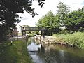
Looking towards the terminal basin of the Calder and Hebble Navigation, from a point near the junction with the Rochdale Canal
|
|
| Specifications | |
| Maximum boat length | 57 ft 6 in (17.53 m) |
| Maximum boat beam | 14 ft 2 in (4.32 m) |
| Status | Open |
| Navigation authority | Canal and River Trust |
The Calder and Hebble Navigation is a wide waterway in West Yorkshire, England. It has special locks and bridges that fit boats up to 14-foot-wide (4.3 m). Building work to improve the River Calder and the River Hebble started in 1759. The first part of the canal, which included 5.7 miles (9.2 km) of new channels, was finished in 1770. It has been open for boats ever since.
Important improvements were made over time. For example, the Salterhebble branch to Halifax opened in 1828. Longer channels were also built to avoid parts of the river. Trade became easier when the Rochdale Canal opened in 1804. This canal created a direct route from Sowerby Bridge to Manchester.
Later, the canal was leased to railway companies. This happened when railways became popular. Some locks were made bigger, but many stayed the same. These locks were designed for "Yorkshire Keels," which are a type of boat. At 57 feet (17 m), they are among the shortest locks on England's canal network. For a while, the canal was a "dead end" for boats. But then, people became interested in using canals for fun. The Rochdale Canal reopened in 1996, and the Huddersfield Narrow Canal reopened in 2001. This means the Calder and Hebble Navigation is now part of three exciting cruising routes across the Pennine hills.
Contents
By the early 1700s, the Aire and Calder Navigation had made the River Calder navigable up to Wakefield. The goal of the Calder and Hebble Navigation was to extend this waterway further west. They wanted to reach Sowerby Bridge, which is close to Halifax.
First Attempts to Build the Canal
The first try to get permission from Parliament was in 1740. People from Halifax, Ripponden, and Elland asked for it. A surveyor named John Eyes planned a route. It would use the River Calder, then the River Hebble, and finally the Halifax Brook to reach Halifax. This plan included 24 locks and almost 10 miles (16 km) of new channels. But the plan failed. Local landowners worried about floods, and mill owners feared it would stop their water supply. Also, people building new roads along the same route were against it.
John Smeaton's Plan and Construction Begins
A second attempt started in 1756. They asked a famous engineer named John Smeaton to create a new plan. He surveyed the area in 1757. His plan included dredging (cleaning out) shallow parts of the river. It also involved building 5.7 miles (9.2 km) of new channels and 26 locks. These locks would help boats climb 178 feet (54 m) from Wakefield to the Halifax Brook. People from Rochdale wanted the canal to go all the way to Sowerby Bridge. An Act of Parliament was passed on June 9, 1758, for this longer route.
Construction began in November 1759, with Smeaton leading the work. By November 1764, the canal was open up to Brighouse, about 16 miles (26 km) from Wakefield. They had borrowed a lot of money. Some people wanted to stop building, but others wanted to finish the whole project. In 1765, James Brindley took over from Smeaton. The work was almost done by 1767. However, big floods in October 1767 and February 1768 caused a lot of damage. Smeaton was asked to come back in 1768 to finish the repairs.
Finishing the Canal and New Company
More floods caused even more damage. By this time, about £64,000 had been spent. The people in charge couldn't borrow more money. So, a new law was passed on April 21, 1769. This law created the "Company of Proprietors of the Calder and Hebble Navigation." This company was made up of the people who had loaned money. They could also borrow more money. This was the first time the name "Calder and Hebble" was used. The initial phase of the canal was finally finished in 1770. The total cost was around £75,000.
There were some early problems with getting enough water to the Sowerby Bridge section. Smeaton suggested building a tunnel to help. This tunnel was started in 1772 and finished in 1794. Other improvements followed. A new channel was added near Mirfield in 1775. Water levels were raised in 1776 so boats could carry more cargo. New locks were built in 1782 to replace older ones.
Canal and Railways
The Manchester and Leeds Railway company built a railway line between 1839 and 1841. This railway followed the same path as the canal. In 1843, the canal company leased the canal to the railway for £40,000 a year. But this deal was later found to be illegal. So, the Aire and Calder Navigation company leased the canal instead, starting in September 1847.
After this lease ended in 1885, the Calder and Hebble Navigation Company took charge again. They rebuilt many bridges. Commercial boats continued to use the canal until 1981. In 1948, the canal became owned by the government.
The Calder and Hebble Navigation begins in Wakefield. Here, it connects with the Aire and Calder Navigation. It then travels upstream through towns like Mirfield. After Mirfield, it connects to the Huddersfield Broad Canal. The navigation ends at Sowerby Bridge, where it connects with the Rochdale Canal. Other towns you'll find along the way include Horbury, Dewsbury, Brighouse, and Elland.
There used to be a branch of the canal that went to Halifax. This part is no longer open for boats, except for a small section called the Halifax Arm. You can see a sign pointing to the Halifax Arm as you come out of the top lock.
How Boats Use the Canal Now
Since commercial boats stopped using the canal in 1981, it has become a popular place for people to enjoy boating for fun. It passes through beautiful countryside and old industrial areas of Yorkshire. For many years, it was a "dead end," meaning you could only get onto it from the Aire and Calder Navigation at its eastern end.
However, many people worked to restore old canals. This led to the reopening of the Rochdale Canal in 1996. The connection was made at Tuel Lane Lock, just past Sowerby Bridge. Now, you can travel from the Calder and Hebble all the way to Rochdale and Manchester.
The canal always connected to the Huddersfield Broad Canal at Cooper Bridge Junction. But this was also a short dead end until the Huddersfield Narrow Canal was restored in 2001. This canal now links the Broad Canal to Ashton-under-Lyne. From there, you can reach the Midlands and Wales.
From the eastern end, the Aire and Calder Navigation connects to other places. You can go to Lancashire via Leeds and the Leeds and Liverpool Canal. Or you can go east to places like Selby, York, Goole, and the Humber.
Because the Rochdale and Huddersfield Narrow Canals have reopened, the Calder and Hebble Navigation is now part of three "cruising rings." These are circular routes for boats, including the South Pennine Ring, the North Pennine Ring, and the Outer Pennine Ring.
Locks and Boat Sizes
The Calder and Hebble Canal was built for "Yorkshire Keels," which were 57-by-14-foot (17.4 by 4.3 m) long. The first four locks on the lower part of the canal are now longer. They can fit boats up to 120 by 17+1⁄2 ft (36.6 by 5.3 m). But the rest of the locks are still quite short. They are among the shortest on England's waterways. While wide boats are limited to 57 feet (17 m) in length, skilled boaters can fit narrowboats up to about 60 feet (18 m) long into the locks. However, narrowboats are only 7 feet (2.1 m) wide. This means they might have to sit diagonally in the lock. Sometimes, boaters need to remove fenders or use poles to guide the boat. Going down some locks backwards might also be necessary. The middle lock of the "Salterhebble Three" is the shortest of all.
The different boat sizes between the Calder and Hebble and the Rochdale Canal made Sowerby Bridge very important. Long boats from Lancashire had to unload their goods there. Then, the goods were moved to shorter boats at Sowerby Bridge Wharf.
Special Tools and River Sections
A unique feature of the Calder and Hebble locks is the "handspike." This is a piece of wood, about 2-by-4-inch (5 by 10 cm), shaped to be held with two hands. Boaters on this canal need to carry a handspike in addition to a "windlass." The handspike is used to open the simple gear that lifts the lock paddles. These paddles let water in or out of the lock.
Because the navigation includes parts of the river, locks that lead to these river sections have "gauge boards." These boards show how high the river water is using colors:
- Green: River levels are normal, and it's safe to travel.
- Amber: Levels are higher than normal. You need to be extra careful.
- Red: Water levels are too high. The lock is closed, and it's not safe to travel on the river.
Points of Interest Along the Canal
| Point | Coordinates (Links to map resources) |
OS Grid Ref | Notes |
|---|---|---|---|
| Sowerby Bridge Basin | 53°42′35″N 1°54′12″W / 53.7098°N 1.9032°W | SE064237 | Where it meets the Rochdale Canal |
| top of Salterhebble Locks | 53°41′55″N 1°51′27″W / 53.6985°N 1.8575°W | SE095224 | Where it meets the Salterhebble Branch |
| Park Nook Lock (No.21) | 53°41′45″N 1°49′48″W / 53.6957°N 1.8301°W | SE113221 | |
| Brookfoot Lock (No.19) | 53°42′05″N 1°47′51″W / 53.7015°N 1.7976°W | SE134228 | |
| Kirklees Top Lock (No.15) | 53°41′33″N 1°44′48″W / 53.6924°N 1.7466°W | SE168218 | |
| Cooper Bridge Junction | 53°40′59″N 1°44′11″W / 53.6831°N 1.7363°W | SE175207 | Where it meets the Huddersfield Broad Canal |
| Shepley Bridge Lock (No.11) | 53°40′27″N 1°40′31″W / 53.6743°N 1.6754°W | SE215198 | |
| Thornhill Bottom Lock (No.8) | 53°40′28″N 1°37′21″W / 53.6745°N 1.6224°W | SE250198 | Where it meets the Dewsbury Arm |
| Figure of Three Locks (No.5,6) | 53°39′58″N 1°35′50″W / 53.6661°N 1.5971°W | SE267189 | |
| Broad Cut Low Lock (No.3) | 53°39′05″N 1°32′02″W / 53.6513°N 1.5340°W | SE308172 | |
| Thornes Lock (No.2) | 53°39′56″N 1°30′20″W / 53.6655°N 1.5056°W | SE327188 | |
| Fall Ings Lock (No.1) | 53°40′25″N 1°28′56″W / 53.6737°N 1.4822°W | SE343198 | Where it meets the Aire and Calder Navigation |
Images for kids
-
Anchor Pit Flood Gates protect the Kirklees Cut when river levels are high.

