
Huddersfield Narrow Canal facts for kids
Quick facts for kids Huddersfield Narrow Canal |
|
|---|---|
.JPG)
Lock 1E - Start of the Huddersfield Narrow Canal
|
|
| Specifications | |
| Locks | 74 |
| Status | Open |
| Navigation authority | Canal & River Trust |
| History | |
| Principal engineer | Benjamin Outram |
| Date of act | 1793 |
| Date completed | 1811 |
| Date closed | 1944 |
| Date restored | 1981 (locks 22W and 23W, Uppermill) 1987 (Marsden to Slaithwaite) 2001 (Full restoration) |
The Huddersfield Narrow Canal is a special kind of waterway in northern England. It's called an inland waterway because it's not on the coast. This canal stretches for almost 20 miles (about 32 km).
It starts near the University of Huddersfield in Huddersfield. Then it goes all the way to Ashton-under-Lyne. The canal crosses the Pennines, a range of hills. To do this, it uses 74 locks and a very long tunnel called the Standedge Tunnel.
Contents
Building This Amazing Canal
Planning the Route
People first thought about building this canal in 1793. They met at the George Hotel in Huddersfield. An engineer named Benjamin Outram designed the canal. He was recommended by William Jessop.
Outram planned for the canal to start from the Huddersfield Broad Canal. It would follow the River Colne. The canal would climb 438 feet (133 meters) to its highest point. Here, it would go through the long tunnel at Standedge. After the tunnel, it would go downhill through Saddleworth. Finally, it would reach the Ashton Canal near Ashton-under-Lyne.
Many factories like woollen, worsted, and cotton mills were along the route. These factories made fabric and clothes. They promised lots of trade for the canal. But there was a worry about water supply for the factories. So, Outram planned to build several reservoirs to store water.
How the Canal Was Built
Building the canal started in 1794. Workers first marked out the route. They placed pegs or stakes about 50 yards (46 meters) apart. The tops of these stakes showed where the water level would be. This helped them build the banks and dig the channels.
Benjamin Outram oversaw the work. But he was also busy with other projects. So, contractors managed the daily work. Progress was slow and not always steady. Outram was also very sick for a few years. The canal company also didn't have enough money. This was partly because they guessed the costs wrong. Also, some people who promised money didn't pay up.
In 1799, big floods damaged the canal banks and reservoirs. One reservoir, Tunnelend, overflowed. This flooded the village of Marsden. Two aqueducts were also destroyed. Aqueducts are like bridges that carry water. This used up the company's already low funds.
The Stakes Aqueduct was already in use and needed replacing fast. Outram had built it from stone. It was low, so it had four short sections. These narrow openings blocked the huge floodwater. Outram replaced it with a single cast iron structure. It was like another aqueduct he built on the Derby Canal.

Outram made the new Stakes Aqueduct stronger. He made the walls thicker where they joined the base. In 1875, more supports were added to make it even stronger. The Stakes Aqueduct is the oldest aqueduct of its kind still used for its original purpose.
The Standedge Tunnel

The canal uses 74 locks to go up and down the Pennines. But it would have needed many more locks without the very long tunnel. This tunnel goes through the hills that separate the River Colne (flowing to Huddersfield) and the Tame (flowing to Stockport).
The canal tunnel is 5,700 yards (about 5.2 km) long. This makes it the longest canal tunnel in the United Kingdom. Most of it is lined with bricks. But in some parts, the natural rock is left exposed.
The "Black Flood"
In 1810, the Diggle Moss Reservoir broke. This caused another flood in Marsden. Much of the Colne Valley was also flooded. Houses and factories were ruined. Five people sadly lost their lives. The water was so powerful that it carried a fifteen-ton rock two miles (3.2 km) down the valley.
Finally Finished!
Even with all these problems, building the Huddersfield Narrow Canal was a big achievement. It showed how much better engineers had become at planning costs. Thomas Telford's report during the Standedge Tunnel construction was very detailed. His plans were followed exactly. The canal finally opened in 1811.
How the Canal Operated

The canal was used for about 140 years. It was somewhat successful for a while. But it had some challenges. It was narrow, only allowing boats less than 7 feet (2.1 meters) wide. It also had many locks and the very long Standedge Tunnel.
Because of this, it made less money than its main competitor, the Rochdale Canal. The Rochdale Canal had a similar number of locks. But it was twice as wide and had no long tunnel.
The Standedge Tunnel was a big problem. It was built without a towpath. This meant boats couldn't be pulled by horses through the tunnel. Instead, narrowboats had to be 'legged' through. This meant people would lie on their backs and push against the tunnel roof or walls with their feet. Later, professional leggers were hired.
A company worker would chain the tunnel entrance after a group of boats. Then, they would walk over the hill with the boat boys and girls. These children led the boat horses. The worker would unchain the other end of the tunnel before the boats arrived. This journey happened at least twice a day for over twenty years.
Later, a double railway tunnel was built next to the canal tunnel. This hurt the canal's income. Most of the canal was closed in 1944. A small part in Huddersfield stayed open until 1963.
Bringing the Canal Back to Life
For 27 years, the Huddersfield Canal Society worked hard. They campaigned and restored the canal. In 2001, the canal fully reopened for boats. It became one of three ways to cross the Pennines by water again. The other two are the Rochdale and the Leeds and Liverpool canals. Today, the Huddersfield Narrow Canal is used entirely by people boating for fun.
When the canal was closed, some parts were filled in. Some were even built over. During the restoration, most of the filled-in sections were dug out again. The canal now follows almost the same path as it did originally. There are only a few small changes.
Changes in Huddersfield
The Huddersfield Narrow Canal connects to the Huddersfield Broad Canal. This is at the eastern end of Lock 1E. The canal had been filled in under the A629 Wakefield Road. A new bridge was built in 1985. But it was only wide enough for narrowboats. So, the 300-yard (274-meter) section of the broad canal to Lock 1E can't be used by wider boats. This bridge acts as the unofficial border between the two canals.
Because of an old law, the part of the canal from Lock 1E to Queen Street South Bridge was not officially closed. While other locks were removed or damaged, locks 1E and 2E stayed gated. But they eventually fell apart. The old gates were only removed when restoration began.
Two factories, Bates and Sellers Engineering, were built right on the canal's path. They blocked it. The solution was to move the locks upstream of the factories. Then, tunnels were built under the factories. This meant the companies didn't have to move. You can clearly see the changes near the old Lock 2E. There's a framework of girders above the canal. This keeps the deep foundations secure.
Eleven years later, Sellers Engineering moved to a new place. This allowed Lock 3E to be moved again. It went back near its original spot. The part of the canal that was in a tunnel under the factory was brought back to the surface. It is now a feature of the Huddersfield Waterfront area.
-
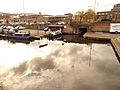
Aspley Basin on the Huddersfield Broad Canal, showing the bridge to the Huddersfield Narrow Canal
-
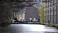
Looking west from Aspley Basin towards the University of Huddersfield
-
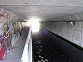
The tunnel under Wakefield Road. It's officially part of the Huddersfield Broad Canal, but only narrowboats can pass through now.
-
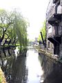
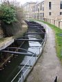
A view of Lock 1E and the canal behind the University of Huddersfield buildings
-
Looking east towards Lock 1E
-
Looking east under the Commercial Street bridge towards Lock 1E
-
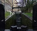
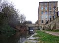
The deep section from the former Lock 2E to the Bates Tunnel
-
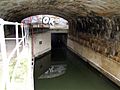
The eastern entrance of the Bates Tunnel
-
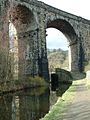
The Saddleworth Viaduct carries the railway over the canal between Saddleworth and Dobcross


.jpg)
.JPG)
.jpg)
.JPG)
.JPG)

Slaithwaite Restoration
In Slaithwaite town centre, the canal section between locks 21E and 23E had been filled in. A car park covered part of its route.
The restoration caused some local debate. It involved cutting down a row of old cherry trees. These trees had been planted along the filled-in canal path. However, the local council said the trees were in poor condition. They probably wouldn't have lasted much longer anyway.
Lock 21E was moved a short distance upstream. This was to the other side of Platt Lane. This change allowed a normal bridge to be built over Platt Lane. Before, there had been a swing bridge.
The section from 22E to 23E goes through a very tight space. The Britannia Road Bridge used to have a hump. But with modern traffic, a hump bridge wasn't practical. So, the water level between 22E and 23E was lowered by 12 inches (300 mm).
Hartshead Power Station

On the western side of the Pennines, the canal passes right through the legs of an electricity pylon at Heyrod. This is near Stalybridge.
The pylon was put up when the canal was closed. The only way to restore the canal was to route it through the pylon's legs.
This is a very unusual situation. No other similar cases are known on waterways that boats can use anywhere else in the world.
The Canal Today
The Huddersfield Narrow Canal is part of the South Pennine Ring. This is a circular route that crosses the Pennines twice. The other crossing is the Rochdale Canal.
The canals are connected at the western (Lancashire) end by the Ashton Canal. At the eastern (Yorkshire) end, they connect via the Huddersfield Broad Canal and part of the Calder and Hebble Navigation.
This canal system passes through many towns. These include Huddersfield, Golcar, Slaithwaite, Marsden, Saddleworth, Diggle, Uppermill, Greenfield, Mossley, Stalybridge, Ashton-under-Lyne, Manchester, Failsworth, Rochdale, Littleborough, Todmorden, Hebden Bridge, Sowerby Bridge, Elland and Brighouse.
The area around the Huddersfield Canal is also a Site of Special Scientific Interest. This means it's a special place for nature.
|
