
Derby Canal facts for kids
Quick facts for kids Derby Canal |
|
|---|---|

The Shacklecross Lock (Borrowash Bottom Lock) undergoing restoration in 2006
|
|
| Specifications | |
| Maximum boat length | 72 ft 0 in (21.95 m) |
| Maximum boat beam | 14 ft 0 in (4.27 m) |
| Locks | 17 |
| Status | Under restoration |
| History | |
| Original owner | Derby Canal Co |
| Principal engineer | Benjamin Outram |
| Date of act | 1793 |
| Date of first use | 1795 |
| Date completed | 1796 |
| Date closed | 1964 |
| Geography | |
| Start point | Derby |
| End point | Swarkestone |
| Connects to | Trent and Mersey Canal, Erewash Canal |
The Derby Canal was a waterway in Derbyshire, England. It stretched about 14 miles (23 km) from the Trent and Mersey Canal at Swarkestone to Derby and Little Eaton. It also connected to the Erewash Canal at Sandiacre.
This canal was approved by a special law in 1793 and finished in 1796. A unique part of it was a section that crossed the River Derwent right in the middle of Derby. An early railway, called the Little Eaton Gangway, helped connect Little Eaton to coal mines near Denby. The canal's main job was to carry coal. It was quite successful until railways arrived in 1840.
Over time, the canal was used less and less. The gangway closed in 1908, and the Little Eaton Branch closed in 1935. The entire canal officially closed in 1964. Since 1994, a group called the Derby and Sandiacre Canal Trust has been working hard to bring the canal back to life. Because the original river crossing is now built over, they have a cool new idea called the Derby Arm. This special machine would lift boats and move them across the river!
Contents
Why Was the Derby Canal Built?
For a long time, people used the River Derwent to move goods from the River Trent. But the river was often too winding, shallow, or full of mud. King John even gave the people of Derby the right to use the river for transport way back in 1204.
Engineers like George Sorocold tried to make the river better for boats in the early 1700s. They planned new cuts, weirs, and locks. Even though boats could reach Derby by 1721, it was still hard to travel when the river was too high or too dry.
In 1770, the Trent and Mersey Canal reached the Trent. This made people think about building new canals. In 1791, two groups suggested different canal plans for Derby. By 1792, these ideas grew into a big plan for a canal from Swarkestone to Derby, with branches to places like Denby and Sandiacre.
Benjamin Outram, a famous engineer, was asked to survey the route. He estimated it would cost about £60,000 to build a wide canal and buy the old river navigation rights. This plan included a special bridge, called an aqueduct, to carry the canal over the River Derwent in Derby.
Outram also suggested building a tramway (a type of early railway) from Little Eaton to Denby. This tramway, known as the Little Eaton Gangway, was one of the first built for public use. It helped save money by avoiding the need for six locks on that part of the route.
Building the Canal: How Was It Done?

The law to build the Derby Canal was passed in 1793. There was strong opposition from other canal owners, but the bill passed anyway.
Work started on the Little Eaton branch and the gangway first. Then came the Sandiacre line, which began in Derby and went east. A short branch from Derby also connected to the river, allowing boats to reach the Darley Abbey mills.
The Sandiacre line followed an old road, passing through places like Borrowash, Draycott, and Breaston. It had two locks near Borrowash and two more to reach the Erewash Canal at Sandiacre. This section was about 9 miles (14 km) long.
The Little Eaton line went north from Derby, parallel to the modern railway. The canal from Derby to Little Eaton opened on May 11, 1795. The very first load of coal from Denby was given to the poor people of Derby. The Sandiacre line opened soon after, on May 30, 1795.
Next, they built the crossing over the Derwent and the line to Swarkestone. A small weir was built on the river to create a basin. A wooden walkway on stilts served as the towpath for horses pulling boats.
The canal then crossed a mill race (a channel of water for a mill) using a special cast-iron aqueduct. This was a very new idea at the time! From there, the canal went south towards Chellaston, going down through Shelton and Fullen's locks. It joined the Trent and Mersey Canal at Swarkestone Junction, about 5.5 miles (8.9 km) from Derby. The route from Derby to Swarkestone opened on June 30, 1796.
Life on the Canal: What Was It Like?
The Little Eaton Gangway was built with cast iron plates. These plates were like rails for wagons. Each wagon carried a box of coal, weighing about 1.6 to 1.9 tons. A crane at Little Eaton wharf would transfer the coal from the wagons to barges. Over time, more tramroads were built, reaching about 6 miles (9.7 km) in total.
The Holmes Aqueduct, the cast-iron bridge over the mill race, was very important. It was the first of its kind, finished just before a similar one by Thomas Telford. However, it had problems and needed repairs several times. It was finally replaced in 1930.
In 1817, the short link between the River Trent and the Trent and Mersey Canal was closed. It wasn't making enough money because the Trent and Mersey Canal charged very high fees for boats using it.
The Derby Canal was quite successful before railways came along. In 1798, it carried over 28,000 tons of coal. By 1803, this had grown to over 50,000 tons! The company encouraged boats to travel the whole canal, which helped it make money. Shareholders received regular payments, reaching 12 percent in 1839. This shows the canal was doing very well.

Why Did the Canal Decline?
By 1830, the canal company started thinking about building its own railways. They even asked George Stephenson, a famous railway engineer, for advice. But they didn't build any.
To stay competitive, the canal lowered its prices in 1834. However, by 1840, three major railway lines had arrived in Derby. This made it very hard for the canal to compete. For example, the fees for using the Little Eaton line dropped by more than half in just five years.
The canal's income fell sharply from £8,180 in 1838 to £2,556 in 1868. Payments to shareholders also dropped. The company tried to sell the canal to railway companies, but no one bought it.
Traffic got even worse when the Butterley Tunnel on the nearby Cromford Canal had to close. The Little Eaton gangway closed in 1908, and the Little Eaton branch closed in 1935. Although some parts stayed open due to objections, commercial traffic on the rest of the canal stopped in 1945. Finally, in 1964, the canal company was allowed to close the entire canal. Over the next 30 years, parts of the canal were built over or left to decay.
Bringing the Canal Back: Restoration Efforts
After the canal closed, some people wanted to save it. In 1947, a local resident asked the Inland Waterways Association for help. Even famous author Tom Rolt tried to navigate the canal to raise awareness, but he couldn't get permission.
In 1956, a local group formed to campaign for restoration. By 1961, Derby Council wanted to fill in the canal. So, the Inland Waterways Association and the Derby Canal Restoration Committee wrote to the Derby Evening Telegraph, asking for the canal to be restored. This caused a big local debate. Despite these efforts, the canal officially closed in 1964.
In the 1990s, with other canals being restored, a study was done in 1994. It showed that bringing the 14 miles (23 km) main line back would cost £17.3 million. To make this happen, the Derby and Sandiacre Canal Trust was formed.
In 1996, a new road, the Derby Bypass, threatened to cut off the canal at Swarkestone. But a solution was found. In 2000, Derby Council helped the trust apply for a £3.2 million grant to create a park by restoring part of the canal.
By 2003, the canal's entire route was protected in local plans. The estimated cost had risen to £34 million, but the trust launched a big plan to raise the money. By 2011, all three local councils had approved the restoration plans.
The new plans do not include crossing the River Derwent at the same level. The original site is now developed, and there are concerns about water supply and flooding. Instead, they proposed an amazing idea called the Derby Arm. This machine would move a special container with water and a boat in a big arc from one side of the river to the other, like a medieval trebuchet.
In 2013, plans for High Speed 2, a new high-speed railway, threatened the canal route. But revised plans in 2016 moved the station to avoid the canal. The trust is still hopeful that the canal can be reopened before any new tramway construction begins.
The Canal Today: What Can You See?

From Swarkestone, you can follow the path of the canal into Derby, almost to Wilmorton. You can still see parts of Fullen's and Shelton Locks, and bridges under Chellaston Road and London Road. Part of the National Cycle Network (NCN 6) follows this section.
In Derby city centre, most traces of the canal are gone due to new roads and buildings like Pride Park. The special weir built across the river for the Derwent Basin is still there behind the Council House. The wooden towpath walkway lasted until 1959. The Holmes Aqueduct was removed in 1971 and later sold for scrap.
You can still see hints of the canal near Derby railway station. An unused part of a railway bridge once crossed the canal. Steel beams in the road near Old Nottingham Road are what's left of a bridge over the Little Eaton line.
Most of the Little Eaton line and gangway have disappeared. However, the old Wharf Building at Little Eaton still stands. The clock house, a Grade II listed building, was built around 1795 for the canal's agent.
The A52 Brian Clough Way was built right on top of the canal between the Pentagon and Spondon. From Spondon to Sandiacre, you can still trace the canal's path. NCN 6 uses the canal route between Borrowash and Breaston. One of the few original bridges, made of red brick, is near Borrowash. The lock-keeper's cottage at Sandiacre Lock also dates back to when the canal opened.
Images for kids
-
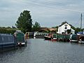
Swarkstone Junction and Toll House in 2007
-
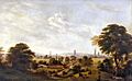
A painting of Derby from Nottingham Road around 1850 by Henry Lark Pratt shows the Derby Canal in the foreground.
-
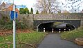
The former canal at Shelton Lock, now a footpath
| Point | Coordinates (Links to map resources) |
OS Grid Ref | Notes |
|---|---|---|---|
| Junction with Erewash Canal | 52°55′03″N 1°17′05″W / 52.9176°N 1.2846°W | SK481358 | |
| Sandiacre Top Lock | 52°54′55″N 1°17′15″W / 52.9154°N 1.2874°W | SK480355 | |
| M1 Motorway embankment | 52°54′24″N 1°18′01″W / 52.9068°N 1.3004°W | SK471346 | |
| Borrowash Bottom Lock | 52°54′08″N 1°22′31″W / 52.9021°N 1.3754°W | SK421340 | |
| Borrowash Top Lock | 52°54′14″N 1°23′02″W / 52.9040°N 1.3838°W | SK415342 | |
| Junction with Little Eaton Branch | 52°55′32″N 1°27′53″W / 52.9255°N 1.4647°W | SK360365 | |
| Pasture Lock | 52°55′45″N 1°27′57″W / 52.9293°N 1.4659°W | SK359370 | |
| Chemical Lock | 52°55′58″N 1°28′00″W / 52.9328°N 1.4667°W | SK359374 | |
| Middle Lock | 52°56′10″N 1°27′53″W / 52.9361°N 1.4648°W | SK360377 | |
| Top Lock | 52°56′31″N 1°27′42″W / 52.9419°N 1.4618°W | SK362384 | |
| Long Eaton Wharf | 52°57′58″N 1°27′49″W / 52.9660°N 1.4635°W | SK361410 | |
| Phoenix Lock | 52°55′34″N 1°28′25″W / 52.9262°N 1.4735°W | SK354366 | |
| White Bear Lock | 52°55′27″N 1°28′17″W / 52.9242°N 1.4713°W | SK356364 | |
| Peggs Flood Lock | 52°55′20″N 1°28′16″W / 52.9223°N 1.4711°W | SK356362 | |
| Days Lock | 52°55′15″N 1°28′10″W / 52.9209°N 1.4695°W | SK357360 | |
| Shelton Lock | 52°52′39″N 1°26′42″W / 52.8774°N 1.4450°W | SK374312 | |
| Fullen's Lock | 52°52′34″N 1°27′00″W / 52.8760°N 1.4500°W | SK371310 | |
| Junction with Trent and Mersey Canal | 52°51′32″N 1°27′03″W / 52.8590°N 1.4507°W | SK370291 | Swarkestone Junction |
