
Derbyshire facts for kids
Quick facts for kids
Derbyshire
|
|||||||||||||||||||||||||||||||||||||||||||||||||||||||
|---|---|---|---|---|---|---|---|---|---|---|---|---|---|---|---|---|---|---|---|---|---|---|---|---|---|---|---|---|---|---|---|---|---|---|---|---|---|---|---|---|---|---|---|---|---|---|---|---|---|---|---|---|---|---|---|
|
The Peak District near Hathersage; Derby Cathedral; and Masson Mill, opened by Sir Richard Arkwright
|
|||||||||||||||||||||||||||||||||||||||||||||||||||||||
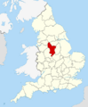
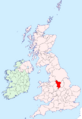
 Ceremonial Derbyshire within England Ceremonial Derbyshire  Historic Derbyshire in the British Isles Historic Derbyshire |
|||||||||||||||||||||||||||||||||||||||||||||||||||||||
| Sovereign state | United Kingdom | ||||||||||||||||||||||||||||||||||||||||||||||||||||||
| Constituent country | England | ||||||||||||||||||||||||||||||||||||||||||||||||||||||
| Region | East Midlands | ||||||||||||||||||||||||||||||||||||||||||||||||||||||
| Established | Ancient | ||||||||||||||||||||||||||||||||||||||||||||||||||||||
| Time zone | UTC±00:00 (Greenwich Mean Time) | ||||||||||||||||||||||||||||||||||||||||||||||||||||||
| • Summer (DST) | UTC+01:00 (British Summer Time) | ||||||||||||||||||||||||||||||||||||||||||||||||||||||
| Members of Parliament | List of MPs | ||||||||||||||||||||||||||||||||||||||||||||||||||||||
| Police | Derbyshire Constabulary | ||||||||||||||||||||||||||||||||||||||||||||||||||||||
|
|||||||||||||||||||||||||||||||||||||||||||||||||||||||
.jpg)
.jpg)


Derbyshire is a county in the East Midlands of England. It shares borders with several other counties, including Greater Manchester and South Yorkshire to the north, and Staffordshire and Cheshire to the west. Derby is the biggest city in Derbyshire, and Matlock is the county town.
The county covers about 2,625 square kilometres (1,014 square miles). Over 1 million people live here. The eastern part of Derbyshire has more towns and cities than the west. The biggest places are Derby (with about 261,400 people), Chesterfield (88,483), and Swadlincote (45,000). For local government, Derbyshire is split into eight areas, plus the city of Derby, which manages itself.
The northern part of Derbyshire is very hilly. It includes the southern end of the Pennines mountain range. Most of this area is part of the beautiful Peak District National Park. The highest point in the county is Kinder Scout, which is 636 metres (2,087 feet) tall. The River Derwent is the longest river in the county, flowing for about 66 miles (106 km). It joins the River Trent south of Derby. Did you know that Church Flatts Farm in Coton in the Elms is the furthest place from the sea in the whole UK?
Contents
History of Derbyshire
The area we now call Derbyshire has a very long history. Humans first visited here about 200,000 years ago! We know this because an ancient stone tool was found near Hopton. Later, during the Stone Age, hunter-gatherers lived in the area. Evidence of these early tribes has been found in limestone caves near the Nottinghamshire border. These findings show people lived here between 12,000 and 7,000 BCE.

You can also find burial mounds from Neolithic settlers across the county. These tombs were used for burying groups of people. They are mostly in central Derbyshire. For example, there are tombs at Minninglow and Five Wells from around 2000 to 2500 BCE. The famous stone circle at Arbor Low, near Youlgreave, is also from about 2500 BCE. It was during the Bronze Age that people started farming and building settlements in Derbyshire.

When the Romans arrived, they were interested in Derbyshire because of its lead ore. They built forts near Brough and Glossop. They also settled near Buxton, which was famous for its warm springs. Another Roman fort was built near where the city of Derby is today.
After the Norman Conquest of England, much of Derbyshire became "royal forests." This meant special laws protected the land for hunting. The Forest of High Peak was in the northwest, and other parts became Duffield Frith. Eventually, the whole area was given to the Duchy of Lancaster.
Geography of Derbyshire
Derbyshire's landscape changes a lot. The north and centre have hills and uplands, while the south and east are flatter. The southern parts of the Pennines mountains stretch across the Peak District in the north. This is where you'll find the highest point, Kinder Scout.
The main rivers are the River Derwent and the River Dove. Both join the River Trent in the south. The River Derwent starts in the moorland of Bleaklow and flows through the Peak District. The River Dove starts in Axe Edge Moor and forms part of the border between Derbyshire and Staffordshire.
Landscape and Rocks
Derbyshire has 11 different types of landscapes. These are shaped by the rocks underneath and how people have used the land. For example, the Dark Peak has moorlands and bogs, while the White Peak has limestone dales.
The rocks in Derbyshire are very old. In the northern, hilly part, you'll find limestones, gritstones, and shales. These rocks are from the Carboniferous period. In the south, the rocks are softer, mostly mudstones and sandstones. These create gentler, rolling hills.

The oldest rocks are the limestones in the White Peak. These rocks are like a big dome that has worn away over time. This has exposed older rocks in the middle. The younger rocks, like coal, are found on the eastern side of Derbyshire.
Mining has been very important in Derbyshire for a long time. People have mined lead here since Roman times. Today, limestone is still quarried for building and making concrete.
Green Belts

Derbyshire has special protected areas called green belts. These areas stop towns and cities from spreading too much. They help keep the countryside natural and open. There are four main green belt areas in Derbyshire:
| Derbyshire green belt area | Part of the larger | Communities contained within | Communities on the outskirts |
|---|---|---|---|
| North West Derbyshire Green Belt | North West Green Belt for Manchester | Glossop, Hadfield, Charlesworth, Furness Vale, New Mills | Hayfield, Chinley, Whaley Bridge |
| North East Derbyshire Green Belt | South and West Yorkshire Green Belt for Sheffield | Dronfield, Eckington, Killamarsh, High Lane/Ridgeway, Holymoorside | Chesterfield, Staveley, Barlborough |
| South East Derbyshire Green Belt | Nottingham and Derby Green Belt for Derby/Nottingham | Ilkeston, Long Eaton, Heanor, Ripley, Borrowash, Duffield, West Hallam | Belper, Derby |
| South Derbyshire Green Belt | Burton upon Trent and Swadlincote Green Belt | Stanhope Bretby, Stanton | Burton-upon-Trent, Swadlincote |
Nature and Wildlife
Derbyshire is home to many different plants and animals. This is because it's in the middle of England and has both high hills and lowlands. Some species that usually live in the north of Britain are found here at their southern limit. Other species that prefer the south are found here at their northern limit.
To protect important habitats, Derbyshire has two main plans: the Peak District Biodiversity Action Plan and the Lowland Derbyshire Biodiversity Action Plan. These plans help record and protect the county's wildlife.
Plants
Since 2002, the county flower for Derbyshire has been Jacob's-ladder. This is a rare flower that grows in certain limestone valleys in the White Peak. Derbyshire has recorded over 1,900 different types of plants. Sadly, 34 plant species that used to grow here have now disappeared from the county.

Derbyshire also has two plants found nowhere else in the world! One is a type of bramble called Rubus durescens. The other is Derby hawkweed (Hieracium naviense), which is only found in Winnats Pass. There's even a special moss, Derbyshire Feather Moss, found in just one tiny spot in a Derbyshire valley. Its exact location is kept secret to protect it.
The Dark Peak area has lots of heather, crowberry, and bilberry. The White Peak dales have more types of plants that like lime. These include different kinds of orchids and common rockrose. Some special plants, like spring sandwort and alpine penny-cress, grow on old lead mining sites.
Animals
Many groups work to protect and record animals in Derbyshire. These include the Derbyshire Ornithological Society (for birds), Derbyshire Mammal Group, and Derbyshire Bat Group. They keep track of animal sightings and share information about rare animals.
Economy

Derbyshire has a mix of different economies. The west is mostly rural, with farming. The north-east and south used to have a lot of coal mining. The rural areas include farmland in the south and upland pasture and moorland in the northern hills.
Derbyshire has many natural resources like lead, iron, coal, and limestone. People have used these for a very long time. Lead has been mined since Roman times. The limestone quarries provide materials for building and making steel. Later, in the 20th century, they were used for cement. The Industrial Revolution also needed a lot of building stone. Today, stone quarrying is still a big industry.

Derbyshire played a big part in the Industrial Revolution. In the late 1700s, there were many fast-flowing streams. This meant factories could use hydropower (water power). Richard Arkwright built some of the first mills here. Because of its importance, part of the Derwent Valley Mills area is now a World Heritage Site.
Some famous companies in Derbyshire include Rolls-Royce, a world leader in aerospace, based in Derby. Thorntons, a well-known chocolate company, is also here. Toyota has one of the UK's largest car factories in Burnaston.
Derbyshire is one of only three counties allowed to make Stilton cheese. The others are Leicestershire and Nottinghamshire. One of the companies making Stilton is Hartington Creamery. They sell their cheese in the UK and export it to other countries.
How Derbyshire is Governed

The county is divided into eleven areas for choosing Members of Parliament (MPs). These MPs represent Derbyshire in the UK Parliament. In the 2024 United Kingdom general election, all these seats were won by the Labour Party. This included the Derbyshire Dales seat, which had been held by the Conservative Party for a very long time.
Here's how the votes and seats changed between the 2019 and 2024 elections:
| Conservative | Labour | Liberal Democrats | Reform UK (formerly Brexit Party) |
Green | Others | |
|---|---|---|---|---|---|---|
| Votes won 2019 | 277,723 |
184,295 |
38,253 |
13,658 |
2,711 |
14,487 |
| Seats won 2019 | 9 |
2 |
0 |
0 |
0 |
0 |
| Votes Won 2024 | 117,424 |
195,568 |
24,897 |
94,292 |
30,348 |
9,101 |
| Seats won 2024 | 0 |
11 |
0 |
0 |
0 |
0 |

Derbyshire has a three-level local government system. There's a county council based in Matlock. Then there are eight smaller district councils. The city of Derby is a special area that manages itself. Derby is still part of Derbyshire for things like ceremonies.
The county has changed slightly over the years. Some areas that used to be part of Derbyshire are now in other counties like Sheffield. However, Derbyshire also gained some land from Cheshire in 1974.
The district councils handle things like local planning, housing, rubbish collection, and parks. The County Council is in charge of bigger things like education, social services, libraries, main roads, and police.

Even though Derbyshire is in the East Midlands, some parts, like High Peak, are closer to northern cities like Manchester and Sheffield. So, they might get services from those areas. For example, the North West Ambulance Service covers parts of Derbyshire.
Derbyshire is also part of larger groups that work together. The County Council and Derby City Council are part of the East Midlands Combined County Authority. This group elected its first Mayor in 2024.
Education
Derbyshire has a comprehensive school system. This means that schools do not select students based on exams. There are also independent schools like Repton School.
Towns and Villages
Derby is the largest and most populated town in Derbyshire. In 2011, about 248,752 people lived in Derby, out of a total of 770,600 in the county. The table below shows towns with more than 10,000 residents.
| Rank | Town | Population | Borough/District | Notes |
|---|---|---|---|---|
| 1 | Derby | 248,752 (2011) | City of Derby | |
| 2 | Chesterfield | 103,788 (2011) | Chesterfield | |
| 3 | Long Eaton | 45,000 | Erewash | |
| 4 | Ilkeston | 38,640 (2011) | Erewash | |
| 5 | Swadlincote | 36,000 (2004) | South Derbyshire | |
| 6 | Belper | 21,823 (2011) | Amber Valley | Figure is for Belper civil parish, which includes Milford and Blackbrook |
| 7 | Dronfield | 21,261 (2011) | North East Derbyshire | Figure is for Dronfield civil parish, which includes Dronfield Woodhouse and Coal Aston |
| 8 | Buxton | 20,836 (2001) | High Peak | |
| 9 | Ripley | 20,807 (2011) | Amber Valley | Figure is for Ripley civil parish, which includes Heage, Ambergate and Waingroves |
| 10 | Staveley | 18,247 (2011) | Chesterfield | Figure is for Staveley civil parish, which includes Mastin Moor, Duckmanton, Inkersall Green and Hollingwood |
| 11 | Glossop | 17,576 (2011) | High Peak | Figure is for the electoral wards of Howard Town, Old Glossop, Dinting, Simmondley and Whitfield. |
| 12 | Heanor | 17,251 (2011) | Amber Valley | Figure is for Heanor and Loscoe civil parish, which includes Loscoe but excludes Heanor Gate |
| 13 | Bolsover | 11,673 (2011) | Bolsover | Figure is for Old Bolsover civil parish, which includes Shuttlewood, Stanfree and Whaley, but excludes part of Hillstown. |
| 14 | Eckington | 11,855 (2011) | North East Derbyshire | Figure is for Eckington civil parish, which includes Renishaw, Spinkhill, Marsh Lane and Ridgeway. |
Historic Areas
Some towns and villages that were once part of Derbyshire are now in other counties:
| Cheshire/Greater Manchester | Marple Bridge, Mellor |
|---|---|
| Leicestershire | Measham |
| South Yorkshire | Mosborough, Totley, Dore |
| Staffordshire | Winshill, Stapenhill, Edingale (Part) |
Media
Because Derbyshire is a large county, different parts get their TV and radio from different places. Southern Derbyshire (like Derby and Matlock) gets TV from BBC East Midlands and ITV Central. Northeast Derbyshire and Chesterfield get TV from ITV Yorkshire and BBC Yorkshire. Western High Peak (like Buxton and Glossop) gets TV from BBC North West and ITV Granada.
Local radio for the county is provided by BBC Radio Derby. Other BBC stations like BBC Radio Sheffield and BBC Radio Manchester also cover parts of Derbyshire. There are also several commercial radio stations available.
Sports
Derbyshire has two professional football teams. Derby County plays in the second tier of English football. Chesterfield plays in the fourth tier. Many other non-league teams play throughout the county. Sheffield F.C., the world's oldest football club, plays in Dronfield, Derbyshire.

Derbyshire also has a cricket team, Derbyshire County Cricket Club. They play in Division Two of the County Championship. There are also rugby league and rugby union clubs across the county.
The county is a popular place for outdoor sports. People enjoy rock climbing, hill walking, hang gliding, caving, sailing on reservoirs, and cycling. Many old railway tracks have been turned into cycle trails, like the Monsal Trail.
The town of Ashbourne is famous for its Royal Shrovetide Football. This is a traditional "medieval football game" played every year on Shrove Tuesday and Ash Wednesday.
Derbyshire is also home to a Muggle quidditch team called Derby Union Quidditch Club. They play against other teams and are part of the UK quidditch scene.
Places to Visit

Derbyshire has many exciting places to visit. You can explore the beautiful Peak District scenery, like Mam Tor and Kinder Scout. There are also charming towns like Bakewell, Buxton, and Derby.
Some popular attractions include:
- Bolsover Castle
- Castleton
- Chatsworth House
- National Tramway Museum at Crich
- Peak Rail (a steam railway)
- Midland Railway (another steam railway)
- Dovedale
- Haddon Hall
- Heights of Abraham
- Matlock Bath
In the north, three large reservoirs (Howden, Derwent, and Ladybower) were built to supply water to cities. The moorland around them is part of the Peak District National Park and is great for walking and cycling.
The National Trust looks after many historic places in Derbyshire that you can visit. These include Calke Abbey, Hardwick Hall, Kedleston Hall, and Sudbury Hall.
Derbyshire also has beautiful gardens, such as those at Melbourne Hall and Chatsworth House. Ardotalia, an ancient Roman fort, is also open to the public for free.
County Symbols

In 2002, the plant charity Plantlife chose the Jacob's-ladder as Derbyshire's county flower.
In 2006, a flag for Derbyshire was suggested by BBC Radio Derby. It has a dark green cross with a golden Tudor rose (a historical symbol) on a blue background. The blue stands for the county's many rivers and reservoirs, and the green for its countryside. This flag was officially registered in 2008.
In 2015, BBC Radio Derby also created a Derbyshire song called "Our Derbyshire." It was first performed at Derby Cathedral.
Population Facts
| UK Census 2011 | Derby | Derbyshire | East Midlands | England |
|---|---|---|---|---|
| Total population | 248,752 | 769,686 | 4,533,222 | 53,012,456 |
| Foreign born (outside Europe) | 9.3% | 1.4% | 6.4% | 9.3% |
| White | 80.2% | 97.5% | 89.3% | 85.5% |
| Asian | 12.6% | 1.1% | 6.4% | 7.7% |
| Black | 3.0% | 0.4% | 1.7% | 3.4% |
| Christian | 52.7% | 63.6% | 58.8% | 59.4% |
| Muslim | 7.6% | 0.3% | 3.1% | 5.0% |
| Hindu | 0.9% | 0.2% | 2.0% | 1.5% |
| No religion | 27.6% | 28.0% | 27.5% | 24.7% |
| Over 65 | 15.1% | 18.6% | 17.1% | 16.3% |
| Unemployed | 5.2% | 3.9% | 4.2% | 4.4% |
In 1801, Derbyshire had a population of 147,481 people. By 2001, this had grown to 956,301 people. In 2006, it was estimated to be 990,400.
Between 1991 and 2001, the county's population grew by 3.0 percent. This was about 21,100 more people. Derbyshire is less crowded than England as a whole, with about 2.9 people per hectare. However, some areas are more densely populated than others. For example, Derbyshire Dales has fewer people per hectare than Erewash.
| Year | 1801 | 1851 | 1901 | 1911 | 1921 | 1931 | 1939 | 1951 | 1961 | 1971 | 1981 | 1991 | 2001 | 2011 |
|---|---|---|---|---|---|---|---|---|---|---|---|---|---|---|
| Derbyshire non-metropolitan county |
132,786 | 223,414 | 465,896 | 542,697 | 565,826 | 590,470 | 613,301 | 637,645 | 651,284 | 666,013 | 687,404 | 717,935 | 734,585 | 769,686 |
| Derby unitary authority |
14,695 | 48,506 | 118,469 | 132,188 | 142,824 | 154,316 | 167,321 | 181,423 | 199,578 | 219,558 | 214,424 | 225,296 | 221,716 | 248,752 |
| Total as a ceremonial county |
147,481 | 271,920 | 584,365 | 674,885 | 708,650 | 744,786 | 780,622 | 819,068 | 850,862 | 885,571 | 901,828 | 943,231 | 956,301 | 1,018,438 |
Derbyshire in Books and Movies
Derbyshire has appeared in many famous stories and films.
- In Jane Austen's novel Pride and Prejudice, the grand house of Mr. Darcy, Pemberley, is in Derbyshire. Chatsworth House in Derbyshire was used as Pemberley in the 2005 film.
- Sir Walter Scott's 1823 novel Peveril of the Peak is partly set in Derbyshire.
- The play Arcadia by Tom Stoppard takes place in a made-up country house in Derbyshire.
- Georgette Heyer's novel The Toll-Gate is set around a fictional toll-gate in Derbyshire in 1817.
- The 1969 film Women in Love had scenes filmed at Elvaston Castle.
- The 1986 film Lady Jane and the 1987 film The Princess Bride both filmed scenes at Haddon Hall. The Princess Bride also filmed in the White Peak and Dark Peak areas.
- The 1988 film The Lair of the White Worm was largely filmed in Derbyshire, including scenes around Thor's Cave.
- The 2008 film The Duchess filmed scenes at Chatsworth House and Kedleston Hall.
- The TV series Peak Practice (1993–2002) was set in Crich and Fritchley.
- The 'twisted spire' of Chesterfield parish church was famous from the opening credits of the 1960s BBC TV show All Gas and Gaiters.
- The Peak District is the setting for a series of crime novels by Sarah Ward.
- Repton School was used in the 1939 and 1983 versions of Goodbye, Mr. Chips.
- Scenes from The Full Monty were filmed in Shirebrook.
- Wingfield Manor was used for the 1980s BBC TV series of The Chronicles of Narnia.
Images for kids
-
Ceremonial Derbyshire within England
-
Historic Derbyshire in the British Isles
-
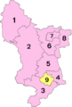
Numbered districts of Derbyshire
See also
 In Spanish: Derbyshire para niños
