White Peak facts for kids
The White Peak, also known as the Low Peak, is a special part of the Peak District in England. It is a high, flat area made mostly of limestone rock. This area is usually between 274 and 427 meters (900 and 1,400 feet) above sea level. It is surrounded by the higher Dark Peak area to the west, north, and east.
Contents
Where is the White Peak located?
The White Peak covers parts of Derbyshire and Staffordshire within the Peak District. It stretches from the Hope Valley in the north down to the Weaver Hills in the south. This area includes towns like Ashbourne, Buxton, Castleton, Matlock, and Wirksworth. It covers about 52,860 hectares (204 square miles).

How the White Peak was formed
The rocks of the White Peak were formed a very long time ago, during the Carboniferous Period. Back then, this whole area was under a shallow sea. Many sea creatures lived there, and their shells and other remains built up over millions of years. This material eventually turned into the thick limestone rock we see today.
Over time, the land moved up and down many times. This caused layers of mud, sand, and peat to form on top of the limestone. All these layers were squeezed and turned into different rocks like gritstone and shales. Later, the land was pushed up into a big dome shape, called the Derbyshire Dome. Wind and rain then wore away the younger rocks, showing the limestone underneath.
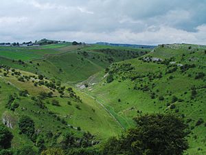
Limestone is a porous rock, meaning water can easily seep through it. This is why you can find many caves, deep gorges, and dry valleys in the White Peak. Famous valleys include Dovedale, Monsal Dale, Lathkill Dale, and the Manifold Valley. Geologists, who study rocks, find this area very interesting. They can see many layers of rock in old quarries and along the Monsal Trail.
Plants and animals of the White Peak
The soil in the White Peak is generally good, thanks to fine dust called loess that was blown here by cold winds long ago. This makes much of the area good for farming, especially for growing grass for animals. You can also find beautiful hay meadows with plants like Rhinanthus minor (yellow rattle) and Galium verum (lady's bedstraw).
On steep hillsides where the soil is thinner, you can find special calcareous grassland. This type of grassland has many different kinds of plants, such as Orchis mascula (early purple orchid), Primula veris (cowslip), and Thymus serpyllum (wild thyme). In some higher places, the soil is more acidic. Here, you might see Viola lutea (mountain pansy) and Vaccinium myrtillus (bilberry).
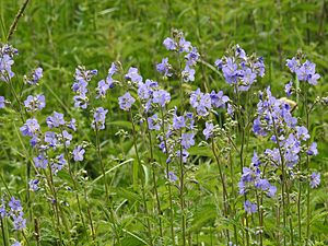
The White Peak is also a very important place for a plant called Polemonium caeruleum (Jacob's ladder). This beautiful flower is the county flower of Derbyshire. It grows especially well on north-facing slopes in the valleys where animals don't graze too much.
Towns and villages
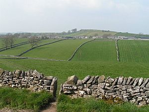
Most of the larger towns in the White Peak, like Matlock, Wirksworth, and Buxton, are just outside the main national park area. However, the town of Bakewell and many smaller villages are right inside the White Peak. If you look closely around places like Tideswell, Hartington, Flagg, Chelmorton, and Youlgrave, you can still see long, thin fields. These fields were created a long time ago when medieval farmers divided their land into strips.
Walking and cycling routes
The White Peak is a great place for outdoor activities. It has many footpaths, bridleways (for horses), and old green tracks that let you explore the area. Some longer routes include the Limestone Way, the Peak District Boundary Walk, and the Pennine Bridleway. There are also popular trails built on old railway lines, such as the Monsal Trail, the High Peak Trail, the Tissington Trail, and the Manifold Way. These trails are perfect for walking and cycling.
See also
 In Spanish: White Peak para niños
 | Toni Morrison |
 | Barack Obama |
 | Martin Luther King Jr. |
 | Ralph Bunche |


