
Matlock, Derbyshire facts for kids
Quick facts for kids Matlock |
|
|---|---|
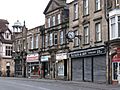
 Matlock town centre |
|

Matlock
|
|
| Population | 9,543 (civil parish 2011) |
| OS grid reference | SK298601 |
| Civil parish |
|
| District |
|
| Shire county | |
| Region | |
| Country | England |
| Sovereign state | United Kingdom |
| Post town | MATLOCK |
| Postcode district | DE4 |
| Dialling code | 01629 |
| Police | Derbyshire |
| Fire | Derbyshire |
| Ambulance | East Midlands |
| EU Parliament | East Midlands |
| UK Parliament |
|
| Website | www.matlock.gov.uk |
Matlock is a historic town in Derbyshire, England. It is known as the county town of Derbyshire. You can find it in the south-eastern part of the beautiful Peak District area. The Peak District National Park is right next to Matlock, to its west.
Just south of Matlock is the spa resort of Matlock Bath. The town of Matlock itself had about 10,000 people living there in 2021. Matlock is about 9 miles (14 km) south-west of Chesterfield. It is also close to bigger cities like Derby (19 miles), Sheffield (20 miles), and Nottingham (29 miles). Matlock is the main office location for the Derbyshire County Council.
Contents
- History of Matlock
- How Matlock is Governed
- Geography of Matlock
- Transport in Matlock
- Hall Leys Park
- Bank Road Landmarks
- Dale Road Features
- Sports in Matlock
- Education and Arts
- Town Centre Development
- Matlock in Films and TV
- Local Media
- Matlock in Books
- Youth Hostels
- Famous People from Matlock
- Images for kids
- See also
History of Matlock
The name Matlock comes from old English words. Mæthel meant 'assembly' or 'speech', and āc meant 'oak tree'. So, Matlock means 'moot-oak', which was an oak tree where meetings were held. In a very old book from 1086, it was called Meslach. Later, in 1196, it became Matlac.
Matlock used to be a famous spa town. This means people came here for the special water from natural springs. The town grew because of the hydrotherapy industry, which used water for health treatments. It also grew because of the cloth mills built along the River Derwent.

Matlock was once a group of small villages. But then, in 1698, warm natural springs were found. This made the town grow very quickly in the 1800s. Many large health centres, called hydros, were built. The biggest one was built in 1853 by John Smedley. This building is now the main office for the Derbyshire County Council. Matlock is also home to the Derbyshire Dales District Council and the Matlock Town council.
How Matlock is Governed
Matlock has a town council. This is the local government closest to the people. It has 11 councillors and meets twice a month. The town council looks after areas like Matlock Town, Matlock Bank, and Starkholmes.
The next level of local government is the Derbyshire Dales District Council. This council covers a large area, including Matlock and other towns like Ashbourne and Bakewell. It has 39 councillors. Matlock is represented by six of these councillors.
The highest level of local government is the Derbyshire County Council. This council is in charge of almost all of Derbyshire. Matlock is represented by one county councillor.
The main offices for all three of these councils are located in Matlock. The Town Council is near the bottom of Bank Road. The District Council is halfway up Bank Road. The County Council is at the very top.
For national decisions, Matlock is part of the Derbyshire Dales area. The person who represents Matlock in the UK Parliament is currently John Whitby.
Geography of Matlock
Natural Features
Matlock is known for its hills and rivers. The town's height changes a lot, from 91 metres (299 ft) in the valley to 203 metres (666 ft) at the top of Wellington Street. Riber Castle overlooks Matlock from the south-east, and Masson Hill is to the south-west. The first people settled in an area now called Old Matlock or Matlock Green. This was where the Bentley Brook river joined the River Derwent. As the town grew, it spread up the steep hillsides.

The natural landscape helped different industries:
- Rocks were dug out from the ground for building.
- Rivers powered mills for corn and cloth.
- Warm spring water from the hills led to the health hydros.
The hills and rivers also affected how transport was built:
- The main road (A6) had to be squeezed next to the river in the narrow valley.
- The railway needed tunnels to get through the hills.
- A special cable tramway was built to go up the very steep Bank Road.
Geology and Rocks

The ground around Matlock is very interesting. The River Derwent valley generally separates two types of rock: sandstones to the north-east and limestones to the south-west. There are also igneous intrusions (where hot rock pushed up from below) into the limestones.
These rocks have been used for quarrying and mining. Sandstones were used for building. Limestones were used for building and making lime. The igneous rocks contained valuable minerals, especially lead. A very rare lead mineral called Matlockite was first found near Matlock in the early 1800s, and it is named after the town!
The path of the River Derwent south of Matlock is special. It cuts through a limestone gorge below High Tor, even though there seemed to be an easier way. Scientists think that landslides or glaciation (ice ages) might have made the river flow this way.
Nearby Places
 |
Youlgreave & Bakewell | Chesterfield & Baslow | Ashover & Clay Cross | |
| Peak District & Hartington | Shirland | |||
| Peak District | Wirksworth & Belper | Ripley |
The Dimple Area
On the western side of Matlock, there's an area called Dimple. It's shown on maps and is bordered by Old Hackney Lane, Hurds Hollow, Dimple Road, and Bakewell Road.
Flooding in Matlock
The River Derwent has sometimes flooded. In November 2019, a big flood affected many parts of England, including Matlock. Sadly, one person, Annie Hall, was swept away and drowned. This flood also damaged many businesses in Matlock.
Transport in Matlock

Trains
Trains run about once an hour between Matlock and Derby on the Derwent Valley Line. These services are run by East Midlands Railway.
Train History
The railway arrived in Matlock in 1849. Matlock railway station was part of a line that connected London and Manchester. However, the part of the line between Matlock and Buxton closed in 1968. This was due to changes in the railway system.
Part of the old railway line, from Wye Dale to Coombs viaduct, is now the Monsal Trail. This is an 8.5-mile (13.7 km) path for walking and cycling.
Heritage Railway

Peak Rail is a special heritage railway. It runs steam trains on a section of the old line between Matlock, Darley Dale, and Rowsley. Since 2011, Peak Rail trains and regular trains share the same station in Matlock.
Buses
Matlock has good bus services. They are run by companies like High Peak Buses, Hulleys of Baslow, and Stagecoach Yorkshire.
Roads
The A6 road goes through Matlock. This road connects Carlisle in the north with Luton in the south. It helps people get to places like Manchester, Buxton, and Derby.
Bank Road Tram
In 1893, the Matlock Cable Tramway was built. It went up Bank Road, a very steep hill, from Crown Square to Wellington Street. It was inspired by the famous cable cars in San Francisco. This tramway was the steepest in the world at the time! It climbed 300 feet (91 m). The tram closed in 1927 because more people started using cars and buses.
Hall Leys Park

Hall Leys Park is a lovely Victorian public park in the centre of Matlock. It opened in 1898. The park is located between the River Derwent and Causeway Lane. It has many things to do and was improved a lot in 2004–2005.
Near Crown Square, at one end of the park, you'll find the town's war memorial and a wishing well. The shelter from the old cable tramway was moved here after the tram closed in 1927.
Further into the park, there's a big grassy area and tennis courts. The old grass tennis courts were replaced with a skateboard park during the park's updates.

In the middle of the park is a Victorian bandstand. Local brass bands often play here in the summer. It's also used for events like the Matlock Victorian Christmas Weekend in December. Next to the bandstand is a footbridge over the Derwent. You can see marks on it that show how high the water rose during floods in the 1960s and 1970s.
Hall Leys Park is now an important part of the town's flood protection. A wall around the park can be sealed off to turn the whole park into a large reservoir during floods. Further down the park, there's a putting green and a Bowls green. There's also a boating lake with small islands, home to many birds like ducks. This lake has the longest-running pleasure boats in the country! A miniature railway runs along the river for half the park's length. At the far end, there's a children's playground that was updated in 2005.
The park sometimes hosts "Continental Markets" and "Farmers' Markets". It's also the main spot for the Matlock Victorian Christmas Weekend every December.
Bank Road Landmarks

Bank Road is a very steep hill in Matlock. It goes from Crown Square up to Wellington Street. Many important buildings are located along this road:
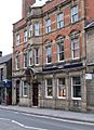
- The Crown Hotel: The original hotel building is now an office. The Crown Hotel is now a Wetherspoon's pub on Bakewell Road.
- Crown Buildings: Built in 1889, this building is opposite the old Crown Hotel and has a café on its ground floor.
- Post Office and Sorting Office: These buildings were built before 1922.
- Police Station: This was built after the Second World War.
- Matlock Town Hall: This building used to be called Bridge House. In 1894, it became the town hall. It was reopened in 1898 and also held courts and other local government offices.
- Our Lady & St. Joseph's Catholic Church: Built in 1883, with a house for the priest added in 1896. A church hall was built next to it in the 1990s.

- Youth Hostel: This building was originally the Smedley Memorial Hospital, built in 1882. It became a YHA youth hostel in 1983 but closed in 2007.
- Matlock Methodist & United Reformed Church: This church was designed in 1882. It has a tall, slender steeple that is now a landmark.
- Old Sunday School: This building is now private homes.
- Old Methodist Church: This church was rebuilt in 1856. Until recently, it housed the Matlock Wurlitzer organ.

- County Hall: This large building used to be Smedley's Hydro. It was built in parts, starting around 1867. It has a tall chimney and beautiful domed glass Winter Gardens, which used to be a ballroom. During World War II, it was used as an RAF hospital.
- Smedley Street: This street crosses Bank Road. It has shops and used to have a post office.

- The Gate public house: This pub, built in 1869, is on the corner of Smedley Street and Bank Road. It is now an arts venue.
Note: Beyond Smedley Street, Bank Road actually becomes Rutland Street.

- Rutland Court: This building was once the Matlock House Hydro, built in 1863.
- Elmtree House: Another former hydro, opened in 1862, now private homes.
- The Old Tram Depot: This building, which used to be where the trams were kept, is now a garage and car repair centre.
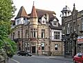
- Rockside Hydro: This impressive building has great views over Matlock. It was built around 1860 and expanded several times. It has two unique octagonal towers with pointed roofs.
Dale Road Features
Dale Road goes from Matlock Bridge all the way to North Parade in Matlock Bath. It is part of the main road (A6) between Derby and Manchester and has many bends.
Dale Road has many examples of Victorian buildings. Here are some of the main features, starting from Matlock Bridge:
- Railway Station and Station House: The train station and its nearby house were designed by Joseph Paxton around 1850. The station house is still much the same as when it was built.
- Matlock Bridge: This is the road bridge over the River Derwent. The first stone bridge was built around the 1200s. It was only wide enough for one vehicle for 550 years! In the early 1900s, it was made twice as wide. Since 2007, the bridge has been one-way for cars.
- RBS Bank (now closed): This old stone building was built in the late 1700s. It has been offices and different banks over the years.
- Queens Head Inn: The building on the corner of Holt Lane and Dale Road dates from the late 1800s. It used to be the Queens Head Inn but is now shops.
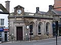
- HSBC Bank (now closed): This building has a striking clock. It used to be a watchmaker and jewellery shop before becoming a bank.
- NatWest Bank (now closed): This building from 1901 is one of the few on Dale Road made of brick.
- Market Hall: Built in 1867–68, the ground floor of this building was a market with 12 shops. The upper floor was used for meetings and entertainment. It is now a row of shops and offices.
- Olde Englishe Hotel: This large building has a striking look with its timber frames and pointed tower. It closed as a hotel in 2009 and is now bars and shops.
- Lime: This building complements the Olde Englishe Hotel. It has a distinctive dome above its entrance and has been used for various businesses.
- Evans Jeweller: This jewellery shop, with its clock sticking out, has been trading from these premises since 1893.
- Holt Terrace: This is a row of five houses that overlooks Holt Lane and Dale Road. Holt Lane used to be the main road until Dale Road was developed.
- John Hadfield House: This building was built after World War II in a former quarry. It was once the headquarters for a stone company and is now used by the Derbyshire County Council.
- The Boat House (now closed): This pub was built in the early 1800s. It is named after a small ferry that used to cross the river here.
- Footbridge to Pic Tor: This footbridge, built in 1922, replaced a ferry in 1872. It connects Dale Road to other areas like Pic Tor and Hall Leys Park.
- Artists Corner: This area has houses built along a sharp bend in Dale Road. Artists have loved this spot for centuries because of the beautiful scenery, especially High Tor.
- High Tor Hotel: This building, built in the early 1800s, is squeezed into the valley below High Tor. It has been a private home, guest house, hotel, and even a school.
-
HSBC Bank
-
NatWest Bank
-
Market Hall with Queens Head beyond
-
Olde Englishe Hotel
-
Evans Jeweller, with Lime and Olde Englishe Hotel beyond
-
Holt Terrace with railway bridge to left
-
Footbridge to Pic Tor
-
Artists Corner
.jpg)


.jpg)
_in_Matlock_Bath,_Derbyshire_-_Geograph-4595383.jpg)
Sports in Matlock

Matlock is home to Matlock Town Football Club. They play in the Northern Premier League Premier Division.
The town also has Matlock and Cromford Meadows Cricket Club and Matlock and District Swimming Club. Matlock Cycling Club has helped train many national and international riders, including Olympian Annie Last.
Matlock's rugby team plays at Cromford Meadows. They have three senior teams and a large junior section with over 250 members.
A new sports centre and swimming pool, called Arc Leisure Matlock, opened in 2011. It was officially opened by Lord Sebastian Coe.
Education and Arts
Matlock has an annual arts festival called Matlock Live, usually in June or July. It features local musicians, dancers, and artists. There are also street performers who raise money for the charity Aquabox. Matlock Music holds concerts at Highfields School. Storytelling events also take place monthly.
History of Education


The first school in Matlock was started in 1647 for local boys. Girls started attending in 1816. This old school has since been taken down.
All Saints Primary School was founded in 1875 and is now the biggest primary school in Matlock. In 1897, another school, the Council School, was built. It is now called Castle View Primary School.
Before Highfields School was created in 1982, Matlock had two secondary schools: Charles White Secondary Modern School and Ernest Bailey's Grammar School. Ernest Bailey's was for students whose parents paid or who passed a special exam. Charles White was for other students.
The two schools were combined to create Highfields School. The Charles White site became the 'lower site' for younger students. A new 'upper site' was built for older students. The Ernest Bailey's building is now used for county council records.
Town Centre Development
For over 10 years, there were plans to build a Sainsbury's supermarket in Cawdor Quarry, an old quarry next to the railway station. Building work started in 2007, and the supermarket opened in October 2007. A new road and bridge were built to help traffic bypass the town centre. The old bridge became one-way for cars leaving town and allows people to walk to the train station, a new bus station, and the supermarket.
In 2010, Crown Square was updated. The old pavements and traffic island were replaced with local sandstone, and new street lights were installed to give the area a more historic look.
Matlock in Films and TV

Matlock has been featured in or inspired several films and TV shows:
- Coming Down the Mountain (BBC drama): Part of the story was set in Matlock, but no filming happened there.
- Women in Love (1969 film): A house on New Street was used as the home of the Brangwen sisters. St Giles' Church was used for a wedding scene.
- A music video for Libera (Salva Me, 1997) was filmed in a rock formation in Matlock Cave.
- Peak Practice (ITV series): Filming locations in Matlock included Highfields School.
- Dead Man's Shoes (2004 film): This movie was filmed in and around Matlock.
- In Denial of Murder (2005 BBC drama): This show was about a local newspaper editor's fight to free someone wrongly accused.
- Skeletons (2010 film): Partially filmed around Matlock.
- Starlings (2012 Sky 1 drama): This show is set in Matlock.
Local Media
For local news and TV, Matlock gets BBC East Midlands and ITV Central.
Matlock's local radio stations include BBC Radio Derby (95.3 FM), Capital Midlands (102.8 FM), and Greatest Hits Radio Yorkshire (102.0 FM).
The Matlock Mercury is the town's weekly local newspaper.
Matlock in Books
Karl Philipp Moritz wrote about Matlock in his book Journeys of a German in England in 1782. He described Matlock as a small place with only a few simple houses.
Letitia Elizabeth Landon wrote a poem called Matlock in 1839.
William Berry's poem "Matlock" appeared in his book A Victim to Glamour: And Other Poems in 1874.
Carola Dunn's mystery book Gone West (2012) is set in Matlock.
Youth Hostels
The Youth Hostels Association (YHA) has its main national office in Matlock, on Dimple Road.
Famous People from Matlock
- Gary Crewe (born 1946), a former British international cyclist.
- Ben Ottewell (born 1976), singer-songwriter for the band Gomez.
- Alan Frederick Parker (born 1944), a guitarist and composer.
- Isy Suttie (born 1978), a comedian and actress.
- Charles Webster (born c. 1965), a DJ and record producer.
Images for kids
-
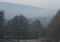
Matlock morning view from east, Lumsdale
-
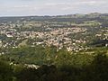
Matlock viewed from a nearby ridge
-
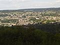
The town enjoys the Sun's rays as shade approaches
-
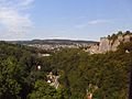
The town as seen from the nearby cable cars


See also
 In Spanish: Matlock para niños
