
Chesterfield, Derbyshire facts for kids
Quick facts for kids Chesterfield |
|
|---|---|
| Town | |
|
Clockwise from top: Knifesmithgate with the Crooked Spire, Town Hall, Scenery, Crooked Spire Parish Church and Market Hall. |
|

Chesterfield
|
|
| Area | 24.32 km2 (9.39 sq mi) |
| Population | 76,402 (2021 Census) |
| • Density | 3,142/km2 (8,140/sq mi) |
| OS grid reference | SK384712 |
| District |
|
| Shire county | |
| Region | |
| Country | England |
| Sovereign state | United Kingdom |
| Post town | Chesterfield |
| Postcode district | S40-S45 |
| Dialling code | 01246 |
| Police | Derbyshire |
| Fire | Derbyshire |
| Ambulance | East Midlands |
| EU Parliament | East Midlands |
| UK Parliament | |


Chesterfield is a lively market and industrial town in Derbyshire, England. It is about 24 miles (39 km) north of Derby and 11 miles (18 km) south of Sheffield. The town sits where the River Rother and Hipper meet. In 2021, about 76,402 people lived in Chesterfield. This makes it the second-largest town in Derbyshire, after Derby.
Chesterfield's history goes back to a temporary Roman fort from the 1st century. The town's name comes from old English words: ceaster (meaning Roman fort) and feld (meaning pasture). Today, Chesterfield is famous for its large street market, which runs three days a week. The town was once a big coal mining area, but most mines have now closed. Its most famous landmark is the unique, crooked spire of the Church of St Mary and All Saints.
Contents
History of Chesterfield
Chesterfield received its market charter in 1204 from King John. This important document allowed the town to hold a market and gave its citizens special rights, similar to those in Nottingham and Derby. In 1266, a battle took place here, where a group of rebel barons were defeated by the king's army.
Later, Queen Elizabeth I gave Chesterfield another charter in the late 1500s. This set up a local government with a mayor and other officials. The town's boundaries grew over time, taking in nearby areas like New Whittington and Newbold in 1920. The current boundaries of Chesterfield were set in 1974.

Chesterfield greatly benefited from the building of the Chesterfield Line railway. This line was part of the route from Derby to Leeds, started in 1837 by George Stephenson. During the railway construction, a large amount of coal was found. Stephenson used this coal and local iron to start a successful mining company.
George Stephenson lived in Tapton House in Chesterfield until he died in 1848. He is buried in Trinity Church. In 2006, a statue of him was put up outside Chesterfield railway station.
Local Government
Chesterfield has a two-part local government system. The Derbyshire County Council handles big services like education, main roads, and social care. The Chesterfield Borough Council manages things like housing, local planning, rubbish collection, and burial grounds.
Both councils have elected councillors. Derbyshire County Council has 64 councillors, and Chesterfield Borough Council has 40. These councillors are chosen by local people every four years.
Chesterfield's Coat of Arms
The town of Chesterfield has its own special coat of arms. It was officially given to the town in 1955.
The main part of the shield shows a pomegranate tree. This symbol is believed to show the town's loyalty to the royal family, as the pomegranate was a royal badge used by queens like Katherine of Aragon. Above the shield, there is a mural crown, which looks like a town wall and shows that Chesterfield is a borough. There is also a Derby Ram, which represents the county of Derbyshire.
On either side of the shield are two birds: a cock (rooster) and a magpie. These birds come from the name of an old inn, the Cock and Pynot Inn, in Old Whittington. This inn was a secret meeting place for people planning against King James II in 1688. The birds wear golden crowns around their necks to show the important people who met there. The motto of Chesterfield is "Aspire," which is a clever nod to the town's famous crooked spire.
Geography
Chesterfield is located where the River Rother and River Hipper meet. It sits in the eastern hills of the Pennines mountain range. People sometimes call Chesterfield the "Gateway to the Peak" because the beautiful Peak District National Park is just to the west of the town.
There are also special green areas around Chesterfield. These areas, called "strategic gaps" and "green wedges," help stop the town from spreading too much. They also keep open spaces for people to enjoy nature and outdoor activities.
Chesterfield's Urban Area
The wider Chesterfield area, including the town and its nearby suburbs and villages like Wingerworth and Staveley, had a population of 112,664 in 2021.

Economy
After the coal mines closed, Chesterfield's economy changed a lot. It moved from mining and manufacturing to service industries. The area used to have many coal mines, even in nearby villages.
Between 1981 and 2002, about 15,000 jobs in the coal industry were lost as all the mines closed. Now, there is little sign of the mining past. Some old mine sites have been turned into walking and cycling paths, like the "Five Pits Trail."
Many large factories in Chesterfield have also closed or moved. For example, Markham & Co., which made huge tunnel boring machines, closed its factory. The site is now a housing estate. Dema Glass, a glass factory, also closed, and its site now has a Tesco supermarket and the Proact Stadium, where Chesterfield Football Club plays.
Today, many smaller businesses are found on industrial estates, with the largest one at Sheepbridge. These businesses include companies that make insulation, kitchen sinks, and roofing materials. There are also large supermarkets like Morrisons, Sainsbury's, and Tesco in the town.
The Chesterfield Royal Hospital is an important employer. It has the only accident and emergency department in Derbyshire outside of Derby. The Royal Mail also has a large Pensions Service Centre in Chesterfield.
Shopping, Entertainment and Leisure
.jpg)
Chesterfield town centre still looks much like it did before World War II. Chesterfield Market is one of the biggest open-air markets in Britain. The market stalls are on both sides of the Market Hall. In the town centre, you can find "The Shambles," a group of narrow medieval streets. Here, you'll find the Royal Oak, one of Britain's oldest pubs.
The Co-op, once Chesterfield's largest department store, closed in 2013. The area has since been redeveloped with a Premier Inn hotel and new shops.
The Pavements Shopping Centre
In the late 1970s, a shopping centre called "The Pavements" was built. It opened in 1981 with a visit from the Prince and Princess of Wales. It has entrances near Chesterfield Market and leads down to the bus station. A bridge connects it to a multi-storey car park.
Chesterfield's large library is also located near The Pavements. In 2007, a fire damaged the Somerfield store in the Precinct, which later reopened as a Tesco Metro.
Vicar Lane Shopping Centre
Vicar Lane was redeveloped in 2000 into an open-air shopping centre just for pedestrians. It now has major shops like H&M and Iceland. This area is located between The Pavements Centre, the markets, and the crooked spire.
Food and Drink
Chesterfield has many places to eat and drink, especially around Church Way and Holywell Street. The "Brampton Mile" is famous for having many pubs along a one-mile stretch of Chatsworth Road.
In 2006, Chesterfield hosted the first international gluten free beer festival. This event was part of the town's regular beer festival.
Arts and Culture
The Winding Wheel is a popular venue for concerts, exhibitions, and other events. Famous performers like Bob Geldof and The Proclaimers have played there. It also hosts the Chesterfield Symphony Orchestra.
The "Pomegranate Theatre" is a historic Victorian building. It has about 500 seats and hosts shows all year. The Chesterfield Museum, which opened in 1994, is also in the same building. The museum and theatre are owned by Chesterfield Borough Council.
Transport
Roads
Chesterfield is located on the A61 and is about 6 miles (10 km) from the M1 motorway. Junction 29 of the M1 connects Chesterfield to the motorway network to the south. There are also good road links to Sheffield, the Peak District, and Matlock.
Buses and Coaches

Stagecoach is the main bus company in Chesterfield. Buses stop at different places around the town centre. A new coach station opened in 2005, serving both local buses and National Express coaches.
Chesterfield taxis are easy to spot, as they are black with white bonnets and boots.
Railways
Chesterfield railway station is on the Midland Main Line. You can catch trains to London St Pancras, Nottingham, Derby, Sheffield, and many other cities.
Chesterfield once had two other railway stations, but they are now closed. Chesterfield Market Place closed in 1951, and Chesterfield Central closed in 1963. Parts of the old railway lines have been turned into roads.
Chesterfield also had a tramway system, which ran from 1882 to 1927.
Air Travel
The closest small airfield is Netherthorpe Airfield near Worksop. For bigger flights, passengers can use East Midlands, Leeds Bradford, Doncaster Sheffield, Manchester, and Birmingham airports. All are within a two-hour drive.
Canal
The Chesterfield Canal used to connect the town to a network of waterways. It was mainly used for moving goods. Today, parts of the canal have been restored for leisure activities like boating, but the section through Chesterfield is still separate from the rest of the canal system.
Media
Local news and TV shows for Chesterfield are provided by BBC Yorkshire and ITV Yorkshire.
You can listen to local radio stations like BBC Radio Sheffield and Greatest Hits Radio North Derbyshire. There are also internet radio stations such as S41 Radio and Spire Radio.
The town is also home to the Derbyshire Times, a local newspaper.
Education
Chesterfield has many schools for different age groups.
Primary Schools
- Abercrombie Primary School
- Brockwell Junior School
- Cavendish Junior School
- Christ Church CofE Primary School
- Hady Primary School
- Spire Junior School
- St Joseph's Catholic and CofE (VA) Primary School
- St Mary's Catholic Primary
- William Rhodes Primary and Nursery School
Secondary Schools
- Brookfield Community School, Brookside
- Outwood Academy Hasland Hall, Hasland
- Outwood Academy Newbold, Newbold
- Parkside Community School, Boythorpe
- St Mary's Catholic High School, Newbold
Colleges
- Chesterfield College
Religious Sites


Chesterfield is most famous for the crooked spire of its Church of Saint Mary and All Saints. This is why the local football team is called The Spireites.
The spire is twisted 45 degrees and leans about 9 feet 6 inches (2.9 meters) from its true centre. A fun story says that the Devil jumped over the spire in pain after a blacksmith badly shod him, making it crooked. More realistically, the lean might be due to a lack of skilled builders after the Black Death, or the use of wood that wasn't properly dried. Another idea is that it twisted when 33 tons of lead sheeting were added to the spire in the 17th century, which was too heavy for the original structure.
The church tower has ten bells, made in 1947. The heaviest bell weighs about 25 long cwt (1,270 kg).
Another important church in Chesterfield is the Annunciation Church, which was founded by the Jesuits in 1854.
Sports and Leisure
Football
Chesterfield F.C. is known as the Spireites, named after the crooked spire. The club used to play at the Recreation Ground (Saltergate) but moved to a new stadium in 2010. The team mostly plays in the third and fourth levels of English football.
Chesterfield Ladies FC has women's and girls' teams. They play at Queen's Park Annexe. The town also has a large amateur Sunday football league with over 100 teams.
Rugby Union
Chesterfield Panthers Rugby Union Football Club started in 1919. It has men's, ladies', and many junior teams. In 2013, the club moved to a new, specially built ground with three pitches.
Chesterfield Spires RLFC is a rugby league club formed in 2003.
Cricket
Chesterfield Cricket Club is an amateur cricket club based at Queen's Park. The club has a long history, going back to the mid-1700s. They play in the Derbyshire County Cricket League, which is a top league for local cricket in Derbyshire.
Hockey
Chesterfield Hockey Club, founded in 1899, plays in the Yorkshire and North East Region Hockey League.
Athletics
Chesterfield & District Athletic Club trains and hosts events for both junior and senior athletes. They are based at Tupton Hall School.
Swimming

Chesterfield Swimming Club is the biggest competitive swimming club in North Derbyshire. It is based at the Queen's Park Sports Centre. In 2012, the club was promoted to the top division of the Arena National Swimming League.
Tennis
Chesterfield Lawn Tennis Club is the largest tennis centre in North Derbyshire. It has 3 indoor and 7 outdoor courts.
Golf
Chesterfield Golf Club was founded in 1897. It is an 18-hole golf course located near Walton.
Queen's Park
Queen's Park, just outside the town centre, has recently been improved with a lot of money. This allows it to host county cricket matches again. The park officially opened in 1893 to celebrate Queen Victoria's Golden Jubilee. It has a cricket field, a lake, a conservatory, a bandstand, and a miniature railway.
Queen's Park Sports Centre
A new £11.2 million Queen's Park Sports Centre opened in January 2016. It has an eight-lane swimming pool, a learner pool, a gym, an eight-court sports hall, squash courts, training rooms, an exercise studio, a climbing wall, and a café.
Skate Park
A large skate park, covering 565 square meters, opened in June 2009. It is located behind Ravenside Retail Park.
Public Services
Chesterfield is kept safe by Derbyshire Constabulary, the local police force. The main police station is in New Beetwell St.
The town has two NHS hospitals. Chesterfield Royal Hospital NHS Foundation Trust in Calow has maternity services and an accident and emergency department. The smaller Walton Hospital is run by Derbyshire Healthcare NHS Foundation Trust.
Emergency medical services are provided by the East Midlands Ambulance Service (EMAS) and the Derbyshire, Leicestershire & Rutland Air Ambulance.
Derbyshire Fire and Rescue Service covers Chesterfield. The fire station moved to a new building at Spire Walk Business Park in 2012.
Notable People from Chesterfield
Many interesting people come from Chesterfield or have strong connections to the town. Here are a few:
- Olave Baden-Powell (1889–1977), wife of Robert Baden-Powell and Chief Guide.
- Millie Bright (born 1993), plays football for the England team.
- Paul Burrell (born 1958), a former royal butler and author.
- Barbara Castle (1910–2002), a Labour cabinet minister.
- Paul Cummins (born 1977), an artist famous for creating the poppy display Blood Swept Lands and Seas of Red at the Tower of London.
- Fred Davis (1913–1998), a well-known snooker player.
- Simon Groom (born 1950), a presenter on the children's TV show Blue Peter.
- Sir John Hurt (1940–2017), a famous actor who was knighted for his services to drama.
- Violet Markham (1872–1959), a writer, social reformer, and the first female Mayor of Chesterfield.
- Henry Normal (born 1956), a writer, poet, and TV producer.
- Liam Pitchford (born 1993), a British Olympic table tennis player and a two-time Commonwealth Games gold medallist.
- Sir Robert Robinson, who won the Nobel Prize in Chemistry for his work on plant dyes.
- Joe Screen (born 1972), an international speedway rider.
- Phil "Philthy Animal" Taylor (1954–2015), the drummer for the band Motörhead.
- Mark Webber (born 1970), a rock guitarist in the band Pulp.
- Bob Wilson, an international footballer and broadcaster.
Other famous people connected to Chesterfield:
- Gordon Banks (1937–2019), England's World Cup-winning goalkeeper, played for Chesterfield from 1955 to 1959.
- Tony Benn (1925–2014), a Labour MP for Chesterfield from 1984 to 2001.
- George Stephenson (1781–1848), the engineer behind the world's first public railway, lived in Tapton House, which is now part of Chesterfield College. A statue of him is outside Chesterfield station.
Twin Towns
Chesterfield is twinned with several towns around the world. This means they have special friendly relationships and often share cultural exchanges.
Arms
|
Images for kids
-
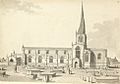
The church in the 18th century as sketched by Samuel Hieronymus Grimm.
-
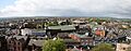
Panorama of Chesterfield taken from the Crooked Spire.
-
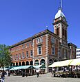
Part of Chesterfield's market and the Market Hall.
-
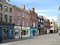
Low Pavement, Chesterfield.
-
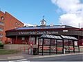
Chesterfield coach station.
-
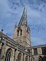
The crooked spire today.
-
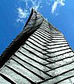
The twist in the Spire.
-

Chesterfield Swimming Club logo.

See also
 In Spanish: Chesterfield para niños
