
M1 motorway facts for kids
Quick facts for kids
|
||||
|---|---|---|---|---|
| London-Yorkshire Motorway | ||||
_map.svg) |
||||

Looking north towards junction 37
|
||||
| Route information | ||||
| Part of |
||||
| Maintained by Highways England | ||||
| Length | 193.5 mi (311.4 km) | |||
| Existed | 1959–present | |||
| History | Opened: 1959 Completed: 1999 |
|||
| Major junctions | ||||
| South end | London A406 (A406) 51°34′32″N 0°14′06″W / 51.5755°N 0.2351°W |
|||
J6a → M25 motorway J17 → M45 motorway J19 → M6 motorway J21 → M69 motorway J32 → M18 motorway J42 → M62 motorway J43 → M621 motorway A1(M) motorway |
||||
| North end | Hook Moor (A1(M)) 53°49′22″N 1°20′20″W / 53.8229°N 1.3388°W |
|||
| Location | ||||
| Counties: | Greater London, Hertfordshire, Bedfordshire, Buckinghamshire, Northamptonshire, Leicestershire, Derbyshire, Nottinghamshire, South Yorkshire, West Yorkshire | |||
| Primary destinations: |
London Brent Cross Watford St Albans Hemel Hempstead Luton Milton Keynes Northampton Rugby Leicester Loughborough Nottingham Derby Mansfield Chesterfield Sheffield Rotherham Barnsley Wakefield Leeds |
|||
| Road network | ||||
|
||||

The M1 motorway is a very important road in England. It connects London in the south to Leeds in the north. It was one of the first motorways built in the UK. The M1 was the first UK motorway to link two major cities, London and Birmingham.
About the M1 Motorway
The M1 motorway is about 193 miles (310 km) long. It was built in different stages. Some parts of the motorway opened in 1959. Other sections were finished between 1965 and 1968. The last parts were opened in 1977 and 1999.
This motorway is also part of a larger European road network. It is known as the unsigned European route E13.
History of the M1
The very first part of the M1 opened on 2 November 1959. This section ran between Junction 5 (near Watford) and Junction 18 (near Rugby). Two smaller roads, called spurs, were also opened at this time. These were the M10 at Junction 7 and the M45 at Junction 17. The M1 was built close to the old A5 road.
In 1965, the M1 was extended further north towards Yorkshire. This new part of the motorway goes through the East Midlands. It passes by cities like Leicester, Loughborough, and Nottingham before reaching Sheffield. At Junction 32, another motorway, the M18, branches off from the M1.
Later, in 1972, the M1 was extended right into the centre of Leeds. This part was called the Leeds South Eastern Motorway. It connects with the Leeds South Western Motorway (M621) at Junction 43.
The first ever motorway service station in the UK was built on the M1 in 1959. Today, it is run by a company called RoadChef.
M1 Motorway Junctions
The M1 motorway has many junctions where you can get on or off the road. These junctions connect the M1 to other major roads and cities across England. Here is a list of the main junctions along the M1:
| M1 motorway junctions | |||||
| mile | km | Southbound exits (B carriageway) | Junction | Northbound exits (A carriageway) | Coordinates |
|---|---|---|---|---|---|
| 7.0 | 11.3 | North Circular (West), Brent Cross, Wembley, Hanger Lane, (A406 West) | J1 Southern terminus |
Start of motorway | 51°34′31″N 0°14′05″W / 51.57515°N 0.23471°W |
| 9.1 9.2 |
14.6 14.8 |
Central London (The City), Holloway North Circular (A406)(E) A1 |
J2 | No access | 51°36′14″N 0°14′23″W / 51.60399°N 0.23977°W |
| 12.0 | 19.3 | London Gateway services | Services | London Gateway services | 51°38′06″N 0°15′58″W / 51.63513°N 0.26610°W |
| 13.2 13.5 |
21.3 21.8 |
Harrow, Edgware A41 (A406 North) | J4 | No access | 51°38′10″N 0°18′17″W / 51.63612°N 0.30468°W |
| 17.1 17.5 |
27.5 28.1 |
Harrow, Aylesbury A41 Watford A4008 |
J5 | Aylesbury, Watford, M25 (West) A41 | 51°40′18″N 0°22′08″W / 51.67162°N 0.36894°W |
| 19.7 20.0 |
31.7 32.2 |
North Watford A405 | J6 | St Albans, Harlow, M25 (East) A405 | 51°42′22″N 0°22′55″W / 51.70602°N 0.38182°W |
| 20.4 20.8 |
32.9 33.5 |
Heathrow Airport, Gatwick Airport, M40, M4, M3 | J6a M25 interchange |
No access | 51°43′06″N 0°23′10″W / 51.71831°N 0.38607°W |
| 22.5 22.7 |
36.2 36.6 |
St Albans, Hatfield A414 | J7 | No access | 51°44′57″N 0°24′33″W / 51.74930°N 0.40928°W |
| 23.5 23.8 |
37.8 38.3 |
Hemel Hempstead | J8 | Hemel Hempstead A414 | 51°45′25″N 0°24′59″W / 51.75695°N 0.41641°W |
| 27.9 28.3 |
44.9 45.6 |
Redbourn A5183 | J9 | Dunstable, Redbourn A5183 | 51°49′12″N 0°25′02″W / 51.82000°N 0.41714°W |
| 30.3 30.6 |
48.8 49.2 |
Luton Airport A1081 | J10 | Luton (S) & Airport A1081 | 51°51′14″N 0°25′25″W / 51.85397°N 0.42370°W |
| 33.7 34.0 |
54.3 54.7 |
Luton (Centre), Dunstable A505 | J11 | Luton (Centre), Dunstable A505 | 51°53′36″N 0°28′12″W / 51.89347°N 0.46988°W |
| Dunstable (North), Aylesbury A5, A505, A5505 | J11A | Dunstable (North), Aylesbury A5, A505, A5505 | 51°55′18″N 0°29′28″W / 51.92156°N 0.49122°W | ||
| 38.9 | 62.6 | Toddington services | Services | Toddington services | 51°56′52″N 0°30′10″W / 51.94778°N 0.50275°W |
| 38.5 38.9 |
62.0 62.6 |
Flitwick A5120 | J12 | Flitwick A5120 | 51°57′27″N 0°30′58″W / 51.95744°N 0.51606°W |
| 45.2 45.4 |
72.7 73.1 |
Bedford A421 Woburn, Ampthill A507 |
J13 | Bedford, Milton Keynes (South) A421 | 52°01′36″N 0°36′13″W / 52.02657°N 0.60360°W |
| 49.7 50.2 |
80.0 80.8 |
Milton Keynes, Newport Pagnell A509 | J14 | Milton Keynes, Newport Pagnell A509 | 52°03′32″N 0°42′00″W / 52.05877°N 0.70012°W |
| 53.7 | 86.5 | Newport Pagnell services | Services | Newport Pagnell services | 52°05′00″N 0°44′55″W / 52.08330°N 0.74853°W |
| 61.8 62.3 |
99.4 100.2 |
Northampton, Wellingborough A45 |
J15 | Northampton, Wellingborough A45 | 52°11′09″N 0°53′44″W / 52.18588°N 0.89551°W |
| 64.3 64.9 |
103.5 104.5 |
Northampton, Oxford A43 (M40) Northampton services |
J15a Services |
Northampton, Oxford A43 (M40) Northampton Services |
52°12′35″N 0°56′40″W / 52.20961°N 0.94435°W |
| 67.9 68.3 |
109.2 109.9 |
Northampton A4500 | J16 | Daventry A45 | 52°13′49″N 1°00′58″W / 52.23030°N 1.01598°W |
| 75.1 | 120.8 | Watford Gap services | Services | Watford Gap services | 52°18′25″N 1°07′19″W / 52.30696°N 1.12202°W |
| 76.6 76.9 |
123.3 123.8 |
No access | J17 | Coventry (S) M45 | 52°19′29″N 1°08′26″W / 52.32464°N 1.14069°W |
| 78.5 78.9 |
126.3 126.9 |
Daventry, DIRFT A428 | J18 | Hinckley A5 Rugby A428 DIRFT |
52°21′03″N 1°09′16″W / 52.35089°N 1.15455°W |
| 82.3 82.7 |
132.4 133.1 |
Felixstowe, Corby, Kettering A14 | J19 M6/A14 interchange |
The North West Coventry, Birmingham M6 |
52°24′19″N 1°10′37″W / 52.40522°N 1.17704°W |
| 85.5 86.1 |
137.6 138.5 |
Lutterworth A4303 Rugby (A426) |
J20 | Lutterworth A4303 Market Harborough A4304 |
52°27′01″N 1°11′29″W / 52.45015°N 1.19146°W |
| 96.1 96.6 |
154.6 155.4 |
Coventry, Birmingham M69 (M6) Leicester A5460 |
J21 | Coventry M69 Leicester A5460 |
52°36′01″N 1°11′42″W / 52.60041°N 1.19498°W |
| 97.7 | 157.2 | Leicester Forest East services | Services | Leicester Forest East services | 52°37′09″N 1°12′21″W / 52.61920°N 1.20579°W |
| 99.3 99.5 |
159.8 160.1 |
No access | J21a | Leicester (N), Newark A46 | 52°38′09″N 1°13′05″W / 52.63577°N 1.21798°W |
| 104.3 104.7 |
167.8 168.5 |
Leicester A50, Coalville A511 | J22 | Ashby, Coalville A511 | 52°41′45″N 1°17′33″W / 52.69592°N 1.29240°W |
| 108.8 109.2 |
175.1 175.8 |
Loughborough, Shepshed A512 | J23 | Loughborough, Shepshed A512 | 52°45′37″N 1°16′26″W / 52.76032°N 1.27394°W |
| 113.4 113.6 |
182.5 182.8 |
The SOUTH WEST, Tamworth, Birmingham, A42 (M42) | J23a Services |
East Midlands Donington Park services |
52°49′09″N 1°18′20″W / 52.81929°N 1.30544°W |
| 114.9 115.4 |
184.9 185.7 |
Nottingham, East Midlands Donington Park services |
J24 | Stoke A50 Derby (A6) Nottingham (S) A453 |
52°50′38″N 1°17′45″W / 52.84397°N 1.29570°W |
| 115.8 116.2 |
186.3 187.0 |
Stoke A50 Derby (A6) |
J24a | No access | 52°51′29″N 1°18′04″W / 52.85796°N 1.30106°W |
| 120.0 120.5 |
193.2 193.9 |
Nottingham, Derby A52 | J25 | Derby, Nottingham A52 | 52°54′57″N 1°17′59″W / 52.91589°N 1.29969°W |
| 124.1 | 199.8 | Trowell services | Services | Trowell services | 52°57′44″N 1°16′02″W / 52.96216°N 1.26725°W |
| 126.0 126.6 |
202.8 203.7 |
Nottingham A610 | J26 | Ripley, Nottingham A610 | 52°59′24″N 1°14′04″W / 52.98991°N 1.23455°W |
| 131.5 132.0 |
211.7 212.4 |
Heanor, Hucknall A608 | J27 | Mansfield A608 | 53°03′48″N 1°16′09″W / 53.06342°N 1.26909°W |
| 135.0 135.5 |
217.2 218.0 |
Derby A38 Matlock (A615) |
J28 | Mansfield A38 Matlock (A615) |
53°06′05″N 1°19′26″W / 53.10129°N 1.32398°W |
| 138.3 | 222.5 | Tibshelf services | Services | Tibshelf services | 53°08′19″N 1°19′51″W / 53.13848°N 1.33093°W |
| 141.7 142.3 |
228.1 229.0 |
Mansfield A617 Matlock (A632) |
J29 | Chesterfield A617 | 53°11′52″N 1°19′22″W / 53.19773°N 1.32287°W |
| Markham Vale A6192 Bolsover (A632) |
J29a | Markham Vale A6192 Bolsover (A632) |
53°14′47″N 1°19′52″W / 53.24647°N 1.33111°W | ||
| 148.4 148.8 |
238.9 239.5 |
Chesterfield (A619) Newark A616 |
J30 | Sheffield (S) A6135 Worksop (A619) |
53°17′11″N 1°17′46″W / 53.28651°N 1.29604°W |
| 151.3 | 243.5 | Woodall services | Services | Woodall services | 53°18′56″N 1°16′56″W / 53.31552°N 1.28214°W |
| 153.8 154.2 |
247.5 248.2 |
Worksop A57 | J31 | Sheffield (SE), Rotherham (S) A57 | 53°21′44″N 1°17′00″W / 53.36221°N 1.28347°W |
| 156.3 156.6 |
251.6 252.1 |
The NORTH, Doncaster, Hull M18 | J32 M18 interchange |
The NORTH, Doncaster, Hull, Rotherham (E) M18 | 53°23′30″N 1°16′56″W / 53.39160°N 1.28231°W |
| 158.8 159.2 |
255.6 256.2 |
Sheffield (C), Rotherham (C) A630 | J33 | Sheffield (C), Rotherham (C) A630 | 53°23′55″N 1°20′59″W / 53.39848°N 1.34977°W |
| 161.5 161.7 |
259.9 260.3 |
Sheffield (E), Rotherham (C), Meadowhall A6109: | J34 | Sheffield (E), Rotherham (C), Meadowhall A6178: | 53°25′03″N 1°24′23″W / 53.41754°N 1.40634°W |
| 164.9 165.4 |
265.4 266.2 |
Rotherham (N) A629 | J35 | Rotherham (N) A629 | 53°27′21″N 1°26′43″W / 53.45581°N 1.44539°W |
| 166.7 166.9 |
268.2 268.6 |
No access | J35a | Manchester A616 | 53°28′31″N 1°27′32″W / 53.47525°N 1.45891°W |
| 168.0 168.5 |
270.3 271.2 |
Sheffield (N), Barnsley A61 | J36 | Barnsley (S) A61 | 53°29′47″N 1°28′32″W / 53.49632°N 1.47547°W |
| 172.1 172.6 |
276.9 277.8 |
Barnsley, Manchester A628 | J37 | Manchester, Barnsley A628 | 53°32′55″N 1°30′56″W / 53.54872°N 1.51568°W |
| 176.4 176.9 |
283.9 284.7 |
Huddersfield A637 | J38 | Huddersfield A637 | 53°36′11″N 1°33′03″W / 53.60297°N 1.55092°W |
| 178.5 | 287.2 | Woolley Edge services | Services | Woolley Edge services | 53°37′18″N 1°32′54″W / 53.62161°N 1.54821°W |
| 179.9 180.4 |
289.5 290.4 |
Denby Dale A636 | J39 | Wakefield A636 | 53°39′02″N 1°31′43″W / 53.65064°N 1.52869°W |
| 182.6 183.0 |
293.8 294.5 |
Wakefield, Dewsbury A638 | J40 | Dewsbury, Wakefield A638 | 53°41′01″N 1°33′18″W / 53.68357°N 1.55508°W |
| 185.1 185.6 |
297.9 298.7 |
Wakefield, Morley A650 | J41 | Wakefield A650 | 53°42′56″N 1°32′07″W / 53.71556°N 1.53534°W |
| 186.5 187.0 |
300.1 301.0 |
Hull, Pontefract, Manchester, Bradford M62 | J42 M62 interchange |
Manchester, Bradford, Leeds/Bradford Hull M62 |
53°43′51″N 1°30′43″W / 53.73087°N 1.51195°W |
| 188.4 189.0 |
303.2 304.1 |
No access | J43 | Leeds M621 | 53°45′17″N 1°30′53″W / 53.75460°N 1.51461°W |
| 189.4 189.9 |
304.8 305.6 |
Leeds A639 (M621) |
J44 | Leeds (S) A639 | 53°45′45″N 1°29′29″W / 53.76256°N 1.49139°W |
| 190.8 191.2 |
307.1 307.7 |
Leeds A63 | J45 | Leeds (SE) A63 | 53°46′34″N 1°28′13″W / 53.77613°N 1.47041°W |
| 193.7 194.0 |
311.7 312.2 |
Leeds (E) A6120 | J46 | Leeds (E), Leeds/Bradford Selby A63 |
53°47′31″N 1°25′35″W / 53.79198°N 1.42646°W |
| 196.6 197.0 |
316.4 317.1 |
Castleford A656 Garforth A642 |
J47 | Garforth A642 The SOUTH (A1(M)) |
53°48′20″N 1°21′41″W / 53.80557°N 1.36149°W |
| 197.7 | 318.1 | Start of motorway | A1(M), J43 Northern terminus |
The NORTH, Wetherby A1(M) York (A64) |
53°49′18″N 1°20′19″W / 53.82178°N 1.33866°W |
Notes
|
|||||
| 1.000 mi = 1.609 km; 1.000 km = 0.621 mi | |||||
Images for kids
-
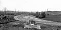
Looking north from B579 bridge at Chalton. Former cement works at Sundon to the right (May 1958)
-
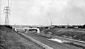
Looking north from a similar position south of Toddington services (July 1959)
-
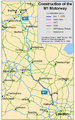
Map showing construction dates of sections of the M1
-
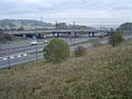
M1 at Junction 4. The old overhead lane control gantries are still visible, which were replaced with newer, verge-mounted MS4 variable message signs in 2008.


See also
 In Spanish: Autopista M1 (Reino Unido) para niños
