National Highways facts for kids
 |
|
|
Formerly
|
|
|---|---|
| Government-owned company | |
| Industry | Highway authority |
| Founded | 1 April 2015 |
| Headquarters | Bridge House 1 Walnut Tree Close Guildford GU1 4LZ |
|
Area served
|
|
|
Key people
|
|
| Owner | HM Government |
|
Number of employees
|
6,000 (2024) |
National Highways (NH) is a company owned by the government. Its main job is to look after, fix, and make better the big roads in England. These include motorways and major A roads.
National Highways also helps set the rules for road design across the whole United Kingdom. They do this through a guide called the Design Manual for Roads and Bridges. In England, they give drivers information using road signs and their Traffic England website. They also have special traffic officers who help with problems on the roads. Plus, they manage projects to improve the road network.
The company started as the Highways Agency in 1994. It became a government-owned company called Highways England on 1 April 2015. The UK government shared its plans for England's main roads in a document called the Road Investment Strategy. A second plan was released in March 2020. This plan aimed for the company to spend £27 billion between 2020 and 2025 to improve the roads. The company changed its name to National Highways on 19 August 2021.
Contents
How National Highways Started
The Highways Agency was created on 30 March 1994. It was part of the Department for Transport, which is a government department.
In 2010, a review looked at how the government managed its main roads. It found that the Highways Agency was too close to the government. This meant it didn't have a clear long-term plan or steady funding. It also didn't feel as much pressure to be efficient as other similar companies.
So, on 27 June 2013, the government announced a change. The Highways Agency became a government-owned company called Highways England on 1 April 2015.
On 19 August 2021, Highways England announced it would change its name again to National Highways. This new name removed "England" from it. This change happened when Nick Harris became the permanent CEO. Some people thought the "national" part of the name meant it was for the whole UK. This is because the company sets road standards for the whole UK. However, other parts of the UK like Wales and Scotland manage their own roads.
Some people were not happy about the name change. It was the third name for the agency in six years. Many still call it the "Highways Agency." People in other UK countries, especially Wales, also criticized the use of "national." This was because transport decisions are made by the Welsh government, not by National Highways.
What National Highways Does
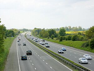
National Highways is in charge of running, fixing, and improving the main road network in England. This network includes motorways and major A roads. It has over 4,000 miles of roads. It also includes bridges, tunnels, drainage systems, and technology like electronic signs.
Even though this network is only about 2% of all roads in England, it carries about one-third of all vehicle traffic.
National Highways also creates the Design Manual for Roads and Bridges (DMRB). This manual provides rules and advice for designing and operating major roads. It is used across the United Kingdom.
How the Road Network Works
National Highways divides its operations into different areas. These areas are generally based on the regions of England. Each area has a team that manages and maintains the roads. Some areas are also managed by special companies called DBFO (Design-Build-Finance-Operate) companies. The M6 Toll is a special road where you pay to use it, and it's also part of this network.
Improving the Road Network
National Highways plans its work in five-year periods called Road Periods. For each period, the government creates a Road Investment Strategy (RIS). This strategy sets out what National Highways needs to achieve and how much money it will get.
For the first Road Period (2015–2020), Highways England spent about £15 billion on its roads. This money also helped with local issues like air quality and cycling safety.
For the second Road Period (2020–2025), National Highways is investing over £27 billion. About £14 billion of this is for making roads better. The rest is for running, fixing, and renewing the roads. This money also helps with environmental issues, user safety, and new ideas. Part of National Highways' funding now comes from Vehicle Excise Duty, which is a tax on vehicles.
How National Highways is Organized
Main Office
The main office for National Highways is in Bridge House, Guildford, Surrey.
National Traffic Information Service (NTIS)
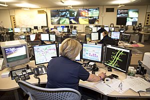
The National Traffic Information Service (NTIS) is run by Sopra Steria for National Highways. It is like the brain for traffic information on England's main roads.
NTIS is based in Quinton, Birmingham. It collects traffic information from over 10,000 sensors on motorways and main roads. These sensors include electronic loops in the road and cameras. It also uses anonymous data from vehicles to get more traffic information.
NTIS can also access nearly 2,000 CCTV cameras, 300 weather stations, and 4,600 electronic road signs. It gets information about incidents from over 250 partners, like the police.
All this data is used to help make decisions and share information with the public. This information is shown on the 4,600 electronic signs by the roads. It's also available on the National Highways website, social media, and through their customer contact centre. News channels and navigation apps like Google Maps also use this information.
Area Teams
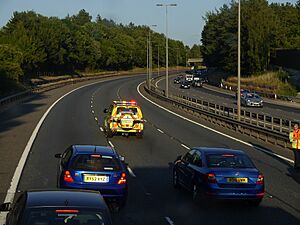
The motorway network is divided into "Areas." These areas are managed by teams that work with the National Highways Traffic Officer Service. They help with incidents, manage traffic in emergencies, and keep the roads in good condition. They are responsible for how the roads in their area are run.
Staff
National Highways has many different types of staff. This includes uniformed traffic officers who work on the roads and in control rooms. They also have experts in engineering, surveying, and accounting. There are also programs for university graduates to join the company.
Looking After Old Railway Bridges
In 2013, National Highways took over the job of looking after the Historical Railways Estate (HRE). This includes old railway bridges and tunnels.
Filling in Bridges
Great Musgrave Bridge
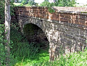
In May and June 2021, National Highways filled the space under a road bridge at Great Musgrave in Cumbria. They used 1,600 tonnes of concrete and other materials. They said it was for safety reasons. However, local railway fans wanted to restore the old railway line under the bridge. They hoped to create a tourist railway.
People were very upset and called it "vandalism." National Highways had to ask for permission after they had already done the work. The local council received 913 complaints and only two messages of support. The government even stepped in to stop National Highways from filling in other old bridges. On 16 June 2022, the council refused to give permission for the work.
Fixing the Musgrave bridge back to how it was would cost £431,000. This is on top of the £124,000 already spent on filling it in. In July 2023, National Highways announced plans to remove the infill and restore the bridge. Locals were concerned because this would mean closing the bridge for three months, causing long detours. Work to remove the material began in August 2023.
After the issues at Great Musgrave, National Highways created a new way to check old railway bridges and tunnels. They now work with experts in history, environment, and travel to make decisions.
Congham Bridge
At Congham in Norfolk, an old railway bridge was filled in by National Highways in 2021. This bridge was designed by a famous engineer named William Marriott. The railway path was planned to become a footpath and cycleway. In January 2023, the local council demanded that National Highways apply for permission for the work they had already done.
Rudgate Bridge
An old stone arch bridge from 1847 at Rudgate near Tadcaster was also filled in by National Highways in 2021. This bridge was designed by John Cass Birkinshaw. National Highways had to ask for permission from the council for this work and for cutting down protected trees.
Traffic England Website
Traffic England is a website that gives you information about traffic. You can see how fast cars are moving between motorway junctions. You can also see what is being shown on the electronic signs and pictures from traffic cameras. This website is run by National Highways' National Traffic Information Service.
Survive Group
The Survive Group is a team effort between National Highways, the police, and companies that help with car breakdowns. Their goal is to make roads safer for people who work on them and for drivers. They also teach people about safe driving. The name Survive stands for "Safe Use of Roadside Verges in Vehicular Emergencies."
The Survive Group website has information about its members and what they are doing. It also gives advice on how to drive safely in different weather conditions and how to plan your journeys.
Images for kids
 | William M. Jackson |
 | Juan E. Gilbert |
 | Neil deGrasse Tyson |


