Quinton, Birmingham facts for kids
Quick facts for kids Quinton |
|
|---|---|
| Suburb and ward | |
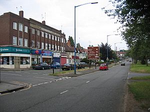
 Hagley Road West, Quinton |
|
| Population | 24,174 (2011 Ward) |
| OS grid reference | SO990846 |
| Metropolitan borough | |
| Shire county |
|
| Metropolitan county | |
| Region | |
| Country | England |
| Sovereign state | United Kingdom |
| Post town | BIRMINGHAM |
| Postcode district | B32 |
| Post town | OLDBURY |
| Postcode district | B68 |
| Dialling code | 0121 |
| Police | West Midlands |
| Fire | West Midlands |
| Ambulance | West Midlands |
| EU Parliament | West Midlands |
| UK Parliament |
|
| Councillors |
|
Quinton is a lively area, or suburb, located about 5 miles (8 km) west of Birmingham city centre in England. It's also known as a ward, which is a local area used for elections.
Quinton used to be part of a different area called Halesowen. But in 1909, it officially became part of Birmingham. For a long time, Quinton was a small village with lots of farms.
In the 1930s, new houses started to be built. By 1980, most of the farmland had been replaced by homes. But don't worry, there's still some green space left! You can find it at Woodgate Valley Country Park. Quinton is also part of the Birmingham Edgbaston area, along with places like Bartley Green and Harborne.
Contents
Quinton's Past
The name Quinton might come from an old word, Cweningtun. This means "the queen's settlement."
Quinton was once part of a very old area called Halesowen parish. In medieval times, much of the land here was owned by a rich religious house called Halesowen Abbey.
Back in the 1840s, when it was known as The Quinton, there were a couple of small coal mines. People living here also made nails for a living. This area was often called Ridgacre until 1901. It was a separate part of Shropshire until 1844, when it moved to Worcestershire. Quinton grew along the main road that connected Kidderminster and Birmingham.
A survey from 1881 showed what jobs people did. Men mostly worked in farming or building. Women often worked in homes as servants or continued making nails.
Bourne College
Before the M5 motorway was built, Quinton stretched further west. Where houses now stand in Chantry Drive, there used to be a school called Bourne College. It was a boarding school for boys, built in 1882.
The college was named after Hugh Bourne, one of the founders of Primitive Methodism. The school had large grounds, about 19 acres (7.7 ha). Hoosen Close, a nearby street, is named after the school's only headmaster.
Bourne College closed in 1928. From 1931, the buildings were used as a home for elderly men, called Quinton Hall. This hall was taken down in 1978.
Joining Birmingham
Quinton, with its 1,100 people and 838 acres (339 ha) of land, became part of Birmingham on November 9, 1909. Most Quinton residents voted to join Birmingham instead of staying with Halesowen.
A big reason for joining was that Quinton could connect to Birmingham's modern drainage and sewer system. For Birmingham, it meant they could build new houses on Quinton's farmland. To celebrate 100 years of this, Birmingham's Lord Mayor planted a tree in Quinton Recreation Ground. On April 1, 1974, Quinton, like the rest of Birmingham, became part of the West Midlands county.
World Wars
During the First World War, a German airship called a Zeppelin flew over Quinton on January 31, 1916. However, its bombs were aimed at Halesowen, and none fell on Quinton.
Quinton stayed a village until the 1930s, when many private houses were built. Factories were not planned for the area because people in Edgbaston worried about smoke blowing their way. This meant Quinton was not a main target for German bombers in World War Two.
Sadly, on July 17, 1941, six crew members of a Royal Air Force bomber died. Their plane crashed in Quinton after hitting a barrage balloon cable during a training flight. The only people killed by German bombs in Quinton were a mother and son. They died on October 18, 1940, when a newsagent's shop on Court Oak Road was hit. Three houses on Wolverhampton Road South were destroyed, and others were damaged in the same attack. Overall, Quinton was not as badly bombed as some other parts of Birmingham.
Quinton's Location and Landscape
Quinton is in the B32 postal district.
The northern edge of Quinton is along the A456/A458 Hagley Road West. The area north of this road is Brandhall, which is in Sandwell. The M5 motorway forms the western edge, separating Quinton from Halesowen. The Bourn Brook in Woodgate Valley Country Park marks the southern border, dividing Quinton from Woodgate and Bartley Green.
Quinton covers about 4.8 square kilometres (1.9 sq mi). The eastern parts were once known as Ridgacre. The original village, around the church, was simply called Quinton or "The Quinton."
High Points and Waterways
The highest point in Quinton is 226 metres (741 ft) above sea level. This is in the old village centre on High Street. The land slopes down to the south and east. The lowest point is 154 metres (505 ft) at the Bourn Brook.
The top of the spire of Christ Church is the highest point of any building in Birmingham. A ridge nearby separates the areas where water flows into the River Severn and the River Trent.
Homes and Buildings
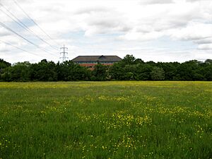
Quinton is mostly a place where people live. There are also small local shops and businesses. An office park has been built on part of Quinton Meadows.
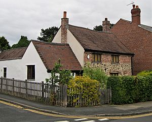
The original Quinton village, near Christ Church, has many Victorian houses. On the corner of Ridgacre Road West and High Street is the Nailer's Cottage. It looks like it's from the 1700s, but its lower walls might be from the 1500s. It's the oldest house in Quinton. The village grew south in the 1970s with the Chichester Drive housing area.
Much of the Ridgacre area has medium-sized, private semi-detached houses. These were built in the 1930s and 1940s. Many of the streets have trees lining them. Building stopped during World War II. In the 1950s, council houses were built. More council housing was built in the 1970s, spreading into the Woodgate Valley. Most of these homes are two-storey houses, but some are three-storey townhouses.
Parks and Green Spaces
The northern part of Woodgate Valley Country Park is in Quinton. It has lots of trees and bushes planted in the late 1980s. There are also some open grassy areas.
Quinton Meadows Local Nature Reserve is a 25-acre (10 ha) area of grassland and woodland. It's located between the M5 motorway and the A456 Quinton Expressway. You can get there from Woodgate Valley Country Park by crossing the Expressway. About 18 acres (7.3 ha) of the meadows were lost when the Quinton Business Park was built in the early 2000s.
Quinton Recreation Ground is next to the M5. You can get to it from Meadow Road. Highfield Farm Recreation Ground has a play area for children, a sports pitch, and exercise equipment. There is also a car park off Highfield Lane.
Roads and Travel
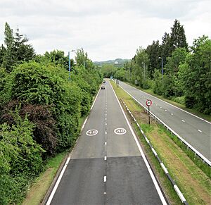
The 1.25-mile (2.01 km) long A456 Quinton Expressway connects Quinton to the M5 motorway at junction 3. The A456 continues as Hagley Road West towards Birmingham city centre. The A458 to Halesowen starts at the Quinton traffic island. A short part of the A4123 enters Quinton as Wolverhampton Road South. It then turns east along Court Oak Road towards Harborne. West Boulevard was extended in 1986 and is now the B4121.
No railway lines or canals pass through Quinton.
People of Quinton
In 2021, the population census showed that 21,377 people lived in Quinton. This was a bit less than in 2001. About 40% of the people in Quinton were from ethnic minority groups in 2021. This was higher than in 2001. In 2021, 46.8% of Quinton's population said they were Christian.
Schools and Community Places
Quinton has one secondary school, Four Dwellings Academy. It also has four primary schools: Quinton Church Primary, World's End Junior, Woodhouse Primary Academy, and Four Dwellings Primary Academy. Quinton Church Primary School has been around since 1846. Pitts Wood, a small old woodland, is next to Woodhouse Primary Academy. The school uses it for learning about nature.
Quinton Library opened on June 2, 1974. It's on the corner of Overdale Road and Ridgacre Road. Next to the library is the Quinborne Community Centre. Its history goes back to 1938. The name Quinborne is a mix of Quinton and Harborne. The centre has a stage and a sports hall called Bennett Hall. This hall was built in 1958 with money from Lord Peter Bennett. The community centre offers classes for learning, activities, and social events. There's also a nursery for young children and a youth club.
The area has three post offices: Quinton post office on Hagley Road West, Faraday Avenue post office on Worlds End Lane, and West Boulevard post office on Court Oak Road.
Quinton police station on Quinton Road West had closed. But in October 2023, the West Midlands Police and Crime Commissioner, Simon Foster, announced it would reopen in 2024.
The main supermarkets are Tesco and Asda. The Tesco store was built in 2007 where a bus depot used to be. The Asda store opened in October 2011 on the site of an old pub.
Quinton Cemetery opened in 1923. It covers about 51 acres (21 ha). Even though it's in Halesowen, Birmingham City Council owns and takes care of it.
The Reel Cinema, which is just over the border in Halesowen, opened in 1939. It was first called the Danilo. It changed names a few times and became a multi-screen cinema in 1973, known as the Quinton Classic.
The Quinton Art Festival started in 2001. It happens every year in May at the Methodist Church hall. You can see up to 300 paintings and drawings. There are also craft stalls, flower displays, and art demonstrations. A concert is held on Friday evening.
Places of Worship
Christ Church is built in an old English style with red sandstone. It cost £2,500 to build in 1840. The "Old Burial Ground" near the church was opened in 1898. Half of it was for members of the Church of England, and the other half for other local residents. The area became overgrown in the 1950s but has been restored since 2006.
St Boniface, a Church of England church on Quinton Road West, was built in 1959. It has brick walls and a steeply sloped roof. The altar inside came from another church.
Quinton Methodist Church was built in 1968. It replaced an older building that was taken down for the M5 motorway. Ridgacre Methodist Church opened in May 1951.
The Catholic church of Our Lady of Fatima is part of the Archdiocese of Birmingham. The church hall was built in 1952. The current church was built next to the hall and opened in 1978. Our Lady of Fatima Catholic Primary School is nearby.
Quinton Evangelical Free Church has been serving the community since 1944. The Christadelphian Hall dates from 1938.
Getting Around Quinton
National Express West Midlands buses serve the area. Buses from Birmingham city centre to Stourbridge, Wolverhampton, and Gornal Wood all stop along Hagley Road West. Other bus routes go to places like Dudley, Queen Elizabeth Hospital, and West Bromwich.
Sports in Quinton
Quinton has three amateur football teams: Quinton Monarch, Quinton Magpies, and Quinton Rangers. All three play in the Warley and District Football League. There's a friendly local rivalry between them, with the Monarch team being quite successful.
Famous People from Quinton
- Adrian Chiles
- Elliot Knight, an actor known for his role in How To Get Away With Murder.
- Joleon Lescott, a footballer who grew up in Quinton.
- Bill Oddie
- Jerome Sinclair, a footballer.
- The Twang, an indie band that started in Quinton.
 | Sharif Bey |
 | Hale Woodruff |
 | Richmond Barthé |
 | Purvis Young |


