
Shropshire facts for kids
Quick facts for kids
Shropshire
Salop
|
|||||||||||||||||||||||||||||||||||||||||||||||||||||||
|---|---|---|---|---|---|---|---|---|---|---|---|---|---|---|---|---|---|---|---|---|---|---|---|---|---|---|---|---|---|---|---|---|---|---|---|---|---|---|---|---|---|---|---|---|---|---|---|---|---|---|---|---|---|---|---|
|
|||||||||||||||||||||||||||||||||||||||||||||||||||||||
| Motto(s):
Floreat Salopia
("May Shropshire flourish") |
|||||||||||||||||||||||||||||||||||||||||||||||||||||||
 |
|||||||||||||||||||||||||||||||||||||||||||||||||||||||
| Sovereign state | United Kingdom | ||||||||||||||||||||||||||||||||||||||||||||||||||||||
| Constituent country | England | ||||||||||||||||||||||||||||||||||||||||||||||||||||||
| Region | West Midlands | ||||||||||||||||||||||||||||||||||||||||||||||||||||||
| Established | Ancient | ||||||||||||||||||||||||||||||||||||||||||||||||||||||
| Time zone | UTC±00:00 (Greenwich Mean Time) | ||||||||||||||||||||||||||||||||||||||||||||||||||||||
| • Summer (DST) | UTC+01:00 (British Summer Time) | ||||||||||||||||||||||||||||||||||||||||||||||||||||||
| Members of Parliament | List of MPs | ||||||||||||||||||||||||||||||||||||||||||||||||||||||
| Police | West Mercia Police | ||||||||||||||||||||||||||||||||||||||||||||||||||||||
|
|||||||||||||||||||||||||||||||||||||||||||||||||||||||


Shropshire (also called Salop) is a historic county in the West Midlands of England. It is a landlocked county, meaning it has no coast. To its west, it shares a border with Wales. To the north, it borders Cheshire, to the east Staffordshire, and to the south, Worcestershire and Herefordshire.
In 2009, a new local government, the Shropshire Council, was created. It took over from older councils. The town of Telford has been a separate local authority since 1998. However, it is still part of the wider ceremonial county of Shropshire.
Most of Shropshire's people and businesses are in five main towns. These are Shrewsbury (the county town), Telford (the largest town), Oswestry, Bridgnorth, and Ludlow. Shropshire also has eighteen market towns, like Whitchurch and Market Drayton.
The Ironbridge Gorge area is a special place. It is a UNESCO World Heritage Site because it was important in the Industrial Revolution. Other historic industrial sites are found in places like Coalbrookdale and Highley.
About a quarter of Shropshire is covered by the Shropshire Hills Area of Outstanding Natural Beauty. This area is mostly in the south. Shropshire is one of England's most rural counties. It does not have many people living there compared to its size. Famous natural spots include The Wrekin and the Clee Hills. The River Severn, Britain's longest river, flows through the county.
The county's special flower is the round-leaved sundew.
Contents
- Shropshire's Past: A Journey Through Time
- Exploring Shropshire's Landscape
- Shropshire's Symbols
- Towns and Villages in Shropshire
- Getting Around Shropshire
- Fun Places to Visit in Shropshire
- Famous People from Shropshire
- Shropshire's Economy: How People Make a Living
- Sports in Shropshire
- Learning in Shropshire
- Images for kids
- See also
Shropshire's Past: A Journey Through Time

Shropshire has a long and interesting history. Long ago, it was part of the lands of the Cornovii tribe. Their main town was probably a hill fort on The Wrekin. When the Romans arrived, their capital became Viroconium Cornoviorum (Wroxeter), which was one of the biggest towns in Roman Britain.
After the Romans left, Shropshire became part of the Welsh Kingdom of Powys. In the 8th century, King Offa of Mercia took over the area. He built Offa's Dyke to mark his territory and defend against the Welsh. Later, the area faced attacks from the Danes. Forts were built in places like Bridgnorth.
After the Normans arrived in 1066, many castles were built. These included Ludlow Castle and Shrewsbury Castle. They helped to control the area and defend against the Welsh. Many churches and religious groups were also started during this time.
Shropshire was a key part of the Welsh Marches in the Middle Ages. This was a border area between England and Wales. It was often involved in power struggles.
The area around Coalbrookdale is very important. It is known as one of the birthplaces of the Industrial Revolution. This is where new ways of making things with machines began.
Where Did the Name Shropshire Come From?
The name "Shropshire" comes from an Old English name, Scrobbesbyrigscīr. This means "Shrewsburyshire". So, the county is named after its main town, Shrewsbury.
"Salop" is an older name for Shropshire. It was often used for short messages. People from Shropshire are still called "Salopians." The motto for Shropshire and Shrewsbury is Floreat Salopia, which means "May Shropshire flourish."
In 1889, the county council was first called Salop County Council. In 1972, Salop became the official name of the county. But people wanted to change it back. So, in 1980, both the county and the council were renamed Shropshire.
How Big is Shropshire?
The border with Wales was set in the 16th century. Today, the ceremonial county border is almost the same as the historic one. Some small areas have been moved. For example, Halesowen became part of Worcestershire.
Exploring Shropshire's Landscape
Geographically, Shropshire can be split into two main parts: the north and the south. The county has many different types of rocks and landscapes.
North Shropshire: Flat Plains and Busy Towns

North Shropshire is mostly flat and fertile. It is part of the wider Cheshire Plain. This is where most of the county's large towns and people are found. Shrewsbury is in the middle. Other towns include Oswestry to the northwest, Whitchurch to the north, and Telford to the east.
The land is good for farming, which is still a big part of the economy. The River Severn flows through this area, passing through Shrewsbury and the Ironbridge Gorge.
The area around Oswestry is a bit more rugged. There are also old mining areas, especially for coal and copper. Today, stone and sand are still mined in places like Haughmond Hill.

Major roads like the A5 and M54 run through the north. These roads are important for business and industry, especially in Telford. There are also many railway lines that meet at Shrewsbury.
Telford was built on an old industrial area. This history is now a big draw for tourists. Museums in Ironbridge, Coalbrookdale, and Broseley show this past. Blists Hill is a popular museum village.
South Shropshire: Hills, Valleys, and Rural Beauty

South Shropshire is much more rural. It has fewer towns and people. The landscape is very different, with many hills, river valleys, and forests. Farming here is mostly about raising animals.
The main towns are Bridgnorth, Ludlow, and Church Stretton. The Shropshire Hills AONB covers a large part of the southwest. This is the only specially protected area in the county. Inside this area are popular hills like the Long Mynd and Stiperstones.

The A49 is the main road, running north to south. A railway line follows the same route. The historic Severn Valley Railway runs from Bridgnorth into Worcestershire.
Church Stretton is sometimes called Little Switzerland because of its beautiful valley. The Clee Hills are also important. One of them, Brown Clee Hill, is the county's highest point.
South West Shropshire is a quiet and remote area. It has Clun Forest, Offa's Dyke, and the River Clun. The small towns of Clun and Bishop's Castle are here.
Shropshire's Weather

Shropshire has a moderate climate. It gets about 760 to 1,000 mm (30 to 40 inches) of rain each year. The Cambrian Mountains in Wales block some of the rain. Hilly areas in the south and west are colder in winter. The flat northern plain has a similar climate to the rest of the West Midlands.
Because it is rural and inland, temperatures can drop very low on clear winter nights. The lowest temperature ever recorded in England was in Shropshire. It was -26.1 °C on January 10, 1982, at Harper Adams University in Edgmond.
Shropshire's Rocks and Fossils

Shropshire has many different types of rocks, from very old to more recent. You can find Jurassic, Carboniferous, and Triassic rocks in the north. In the middle, there are Precambrian and Cambrian rocks. The south has mostly Silurian rocks.
In areas with Silurian rocks, like Mortimer Forest and Wenlock Edge, you can find many fossils. These include shells, corals, and trilobites.
Shropshire's Symbols
The Shropshire County Flag
The Shropshire county flag was officially registered in 2012. It shows three leopard heads on a gold and blue background. These leopard heads are often called "loggerheads."
The Shropshire Coat of Arms
Shropshire's coat of arms also features the three leopard heads. These arms were officially given in 1896. The "loggerheads" name might come from old battering rams that had leopard heads carved on them.
Shropshire's County Flower

In 2002, the round-leaved sundew was chosen as Shropshire's county flower. This plant is a red-colored insect-eating plant. It needs a boggy place to grow. Because of habitat loss, it is now rare. The Long Mynd in Shropshire is one of the few places in England where it can still be found.
Shropshire Day
Shropshire Day is celebrated on February 23rd. This is the feast day of St Milburga. She was an abbess (head of an abbey) at Wenlock Priory. St Milburga was the daughter of an Anglo-Saxon king. The town next to the priory is now called Much Wenlock.
Shropshire's Motto
Shropshire's motto is Floreat Salopia. This means "May Shropshire flourish."
Towns and Villages in Shropshire
Shropshire does not have any cities. However, it has 22 towns. Telford is the largest town, with over 138,000 people. This is about 30% of all the people in Shropshire. Shrewsbury, the county town, has about 71,000 people.
Other important towns include Oswestry, Bridgnorth, Newport, and Ludlow. The historic town of Wellington is now part of the Telford area. Most other places are smaller towns or villages. Some villages, like Bayston Hill, are larger than the smallest town, Clun.
Many larger towns are found along the A5 and M54 roads. Other towns grew up along rivers, like Bridgnorth on the River Severn. Rivers were important for trade and water in the past.
 |
Telford and Wrekin shown within  Rivers, Motorways, 'A' Roads, Settlements |
Largest settlements (by population): Telford (138,241) |
 |


Getting Around Shropshire

Shropshire is connected to the rest of the UK by roads and railways. In the past, rivers and canals were used for transport. Now, canals are mainly used for fun activities like narrowboat holidays.
Three canals in northern Shropshire are managed by the Canal & River Trust. These are the Shropshire Union Canal, the Llangollen Canal, and the Montgomery Canal.
.jpg)
The main transport hub in Shropshire is Shrewsbury. Many important roads and railways pass through it.
Major roads include the M54 motorway, which links Shropshire to the wider motorway network. The A5 also runs east to west through the county. Other key roads are the A49, A53, and A41.

Several major railway lines cross Shropshire. These include the Welsh Marches Line and the Heart of Wales Line. There are also heritage railways, like the Severn Valley Railway. Train companies like West Midlands Trains and Transport for Wales Rail operate services here.
Fun Places to Visit in Shropshire
|
|


Famous People from Shropshire


.jpg)

Many well-known people have come from Shropshire:
- Abraham Darby I: An early industrialist, important in the Industrial Revolution.
- Charles Darwin: A famous naturalist born in Shrewsbury. He developed the idea of evolution by natural selection.
- Robert Clive, 1st Baron Clive: Known as 'Clive of India', born near Market Drayton.
- Matthew Webb: The first person to swim the English Channel.
- Wilfred Owen: A leading poet from the First World War.
- William Penny Brookes: From Much Wenlock, he helped start the modern Olympic Games.
- Joe Hart: A famous football goalkeeper for Tottenham Hotspur and England.
- Greg Davies: A comedian and actor who grew up in Wem.
- K. K. Downing: Guitarist for the band Judas Priest.
Shropshire's Economy: How People Make a Living

In the past, farming was the most important part of Shropshire's economy. Now, more people work in services, like tourism.
Shrewsbury, Ludlow, Much Wenlock, and the Ironbridge Gorge are popular places for tourists. People also enjoy holidays on narrowboats along the restored canals.

Industry is mainly found in Telford, Oswestry, Whitchurch, Market Drayton, and Shrewsbury. Many businesses in towns like Whitchurch are small and family-run. Shrewsbury is becoming a hub for distribution and storage because of its good road links.

Telford and Shrewsbury are the county's main shopping areas. Shrewsbury has historic streets and shopping centres like "Pride Hill" and "Darwin." Telford has a large, modern shopping mall called Telford Shopping Centre. Shrewsbury also attracts many shoppers from mid-Wales.
Well-known companies in Shropshire include Müller Dairy (UK) Ltd in Market Drayton. The Royal Air Force has two bases here: RAF Cosford and RAF Shawbury.
Sports in Shropshire
.jpg)
Shropshire has many sports clubs and facilities. Many are in Shrewsbury and Telford.
One of England's five National Sports Centres is in Shropshire. It is at Lilleshall Hall near Newport. The England football team trained here before winning the World Cup in 1966.
Football Clubs
The three highest-level football clubs in Shropshire are Shrewsbury Town (in EFL League One), A.F.C. Telford United (in National League North), and The New Saints (in the Welsh Premier League).
Many other semi-professional clubs play in lower leagues. The Shropshire Football Association organizes county-wide cup competitions. Some clubs near the Welsh border play in the Welsh league system.
Other Sports to Enjoy

The historic Wenlock Olympian Society Annual Games are held every year in Much Wenlock. These games started in 1850 and include many sports like cricket, volleyball, and athletics.
Shropshire has several golf courses. The Church Stretton Golf Club is the oldest 18-hole course in the county. There is also a horse racing racecourse near Ludlow, called Ludlow Racecourse.

The county is also known for motorsports. The Loton Park Hillclimb and Hawkstone Park Motocross Circuit are near Shrewsbury. The Telford Tigers are the county's ice hockey team.
The Shropshire Star Newport Nocturne is a big one-day cycle race. It is held every four years and is Britain's only floodlit cycle race. Shropshire also has an American football team, the Shropshire Revolution. There are several rugby clubs, including Newport (Salop) Rugby Union Football Club.
Learning in Shropshire

The Shropshire Council area has a comprehensive education system. This means all students go to the same type of school. However, in Telford and Wrekin, there are two selective schools in Newport. These are Haberdashers' Adams School and Newport Girls' High School. The Thomas Telford School in Telford is known as one of the best comprehensive schools in England.
Some children from Shropshire go to schools in Wales.
Shropshire also has many independent schools. These include Ellesmere College, Shrewsbury School, and Oswestry School.
There are three sixth-form colleges for older students: New College, Telford, Shrewsbury Sixth Form College, and Ludlow College.
For higher education, Shropshire has the Telford campus of the University of Wolverhampton. Also, Harper Adams University in Edgmond offers degrees, especially in agriculture. A new campus of the University of Chester opened in Shrewsbury in 2015.
The University of Birmingham runs the Ironbridge Institute in Ironbridge. It offers courses in heritage studies. Shropshire has the highest educational achievement in the West Midlands region.
Images for kids
-
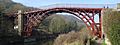
The Iron Bridge at Ironbridge
-

Telford]] [[Telford
-
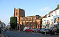
Newport
-
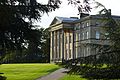
Attingham Park Mansion
-
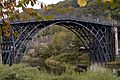
Ironbridge


See also
 In Spanish: Shropshire para niños
